Goathland & Grosmont
North York Moors Walk
Nat Park - North York Moors - North York Moors East
County/Area - North Yorkshire
Author - Lou Johnson
Length - 7.7 miles / 12.5 km Ascent - 900 feet / 273 metres
Time - 4 hours 50 minutes Grade - easy/mod
Maps 

| Ordnance Survey Explorer OL27 | Sheet Map | 1:25k | BUY |
| Anquet OS Explorer OL27 | Digital Map | 1:25k | BUY |
Walk Route Description
Click image to see photo description.
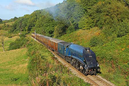
Walk from Goathland exploring the industrial heritage, valleys, and moors north to Grosmont. The route follows good paths and tracks, including one ascent. Along the way you will be able to see steam hauled trains on the North York Moors Railway, follow the original route of the railway opened in 1836, and perhaps use the station refreshment room at Grosmont station. The final section crosses open moorland.
The start is the large pay and display car park in Goathland (grid ref. NZ832013). After parking, walk to north end of the car park (by the toilets) and turn left onto Beck Hole Road. Turn left through a wooden kissing gate and follow the path across a grassed area to the next road. Turn right and walk uphill to a junction. Turn left (signed Beck Hole). After 120 metres turn right at a fingerpost, pass through the kissing gate, and follow the path downhill and under the railway to cross Eller Beck. Once under the railway, bear left and continue beside a wall to Hill Farm and a lane (grid ref. NZ822024).
Turn left over the railway and walk into Beck Hole. Cross the beck and turn right onto a signed footpath just past the pub on your left. After 120 metres you reach a cross path. Turn right onto the signed Rail Tral. When the railway was opened the section towards Grosmont used cables to haul the wagons up the gradient. Along the Rail Trail there are information boards explaining the history of the railway. Follow the Rail Trail downhill for three kilometres. After running beside the railway, the path climbs over a small hill which the railway tunnels through. Dropping down the other side you have a good view of the locomotive workshops before reaching Grosmont Station.
To continue, turn back on yourself and turn left into the churchyard and pass the church and exit through a gate onto a lane. Turn right onto a narrow path by the graveyard and continue across a bridge over the Musk Esk to a lane. Bear right and follow the lane steeply uphill. After 800 metres you pass Dale End Farm. Continue along the lane for a further kilometre to reach Beck Hole Road (grid ref. NZ829034). Turn left to cross moorland. After 800 metres you reach the access road to Greenlands Farm on the left. Follow this track to reach a deep ravine (grid ref. NZ837035). Turn right and follow the path along this quarry which extracted Whinstone. After 400 metres, at a gap in the quarry, turn right and continue down to Beck Hole Road. Cross the road and take the track opposite. An easy descent on a clear track leads you down towards Goathland Station. As you approach the station, fork right down a narrower path which leads to the platforms. Exit the station and return to the car park
Other walks nearby
| Walk 2563 | Egton Bridge & Grosmont from Goathland | moderate | 12.5 miles |
| Walk 1758 | Newton House Plantation & Stony Leas | moderate | 10.3 miles |
| Walk 1922 | Goathland & Howl Moors | moderate | 11.2 miles |
| Walk 1930 | Wheeldale Moor circular | moderate | 11.3 miles |
| Walk 1464 | Sleights Moor | easy/mod | 7.8 miles |
| Walk 1675 | The Esk Valley & Egton High Moor | moderate | 10.5 miles |
| Walk 1743 | Sneaton Thorpe & Littlebeck from May Beck | moderate | 8.9 miles |
| Walk 1602 | Saltergate, Fylingdales & Allerston High Moor | moderate | 11.5 miles |
| Walk 3534 | Dundale Pond & Hole of Horcum from Saltergate | easy/mod | 5.2 miles |
| Walk 2077 | Glaisdale Moor circular | moderate | 11.9 miles |
Recommended Books & eBooks
Trail and Fell Running in the Yorkshire Dales
 Guidebook to 40 of the best trail and fell runs in the Yorkshire Dales National Park. Ranging from 5 to 24 miles, the graded runs start from bases such as Ribblehead, Dent, Sedbergh, Malham and Grassington and take in the region's diverse delights, from castles and waterfalls to iconic mountains such as Whernside, Ingleborough and Pen Y Ghent.
More information
Messaging & Social Media
Message Walking Britain and follow the latest news.

Mountain Weather
Stay safe on the mountains with detailed weather forecasts - for iOS devices or for Android devices.