Flash Circular from Cistern Clough
Peak District Walk
Nat Park - Peak District - The Roaches
County/Area - Derbyshire & Staffordshire
Author - Lou Johnson
Length - 8.0 miles / 13 km Ascent - 1150 feet / 348 metres
Time - 5 hours 10 minutes Grade - moderate
Maps 

| Ordnance Survey Explorer OL24 | Sheet Map | 1:25k | BUY |
| Anquet OS Explorer OL24 | Digital Map | 1:25k | BUY |
Walk Route Description
Click image to see photo description.
An interesting walk from near Flash that includes the upper reaches of the Dove Valley, Axe Edge Moor, Three Shires Head and the Dane Valley, the village of Flash the highest in the UK, and the head of the Manifold Valley. The route uses moorland paths, tracks, and quiet country lanes to explore the varied scenery which is part of the Peak District National Park and Staffordshire Moorlands. The relevant OS 1:25k map is useful.
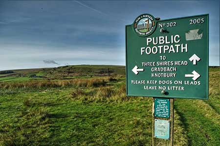
The start is a section of the old A53 now used as a layby at Cistern Clough (grid ref. SK034698). After parking walk up the path at the head of the clough soon joining a lane across Axe Edge Moor. Continue up the road for 500 metres ignoring the first track on the left with a wooden pole as a barrier. Exit left at the next path/track with a single stone marker post (grid ref. SK030702). The path soon bends left and descends to a gate in a wall (grid ref. SK026697). Head through the gate into Staffordshire and continue into a valley with a small stream on your left. The grassy path soon becomes a clearer track, crosses a cattle grid, and joins a tarmac access drive. Continue ahead, downhill, to reach a lane. Fork right (signed Blackclough Farm) and continue down a lovely narrow valley. Where the lane forks right uphill to Blackclough Farm, walk straight ahead, re-entering Derbyshire, to follow a stony track that continues down the valley to reach Three Shires Head (grid ref.SK009685). This attractive location with a packhorse bridge and small waterfalls, is where the Counties of Cheshire, Staffordshire and Derbyshire meet.
After exploration, turn south across a small bridge over a stream. Do not cross the larger packhorse bridge. Continue with the River Dane below on your right to reach a gate (grid ref. SK008678). Once through the gate, fork left and follow the path which arcs left along the base of Turn Edge to reach a cottage. Continue along the track in front of the cottage which soon becomes a narrow tarmac lane. The lane arcs left, passes Hawk's Nest, and climbs up a narrowing valley to turn right (with a gated driveway on the left). At the next junction fork right initially downhill to a small footbridge on the right (grid ref. SK020681).
Cross the bridge and head uphill over Wolf Edge. After crossing several small fields, the route follows a track between walls to reach a wider track. Turn right and after 200 metres, bear slightly left and follow a grassy path across four more fields to re-join the track. Turn left into Flash Village. Continue ahead to pass the New Inn on your left to reach a junction and the church. Turn right onto a path (with fingerpost) in front of the church. The path soon turns left with the churchyard on your left, before turning right through a yard. Exit the yard at the far side and follow a track downhill through several fields. Where the track bends right, continue downhill to the busy A53.
Cross the A53 and take the track heading sharp left downhill (signed to Nield Bank). You are now following the Manifold Trail. Cross the infant River Manifold and head up to pass Nield Bank (a cottage) on your right. The route then heads north-east across an area of open access land to reach a road at Summerhill (grid ref. SK037674). Turn right and then immediately fork left past a Summerhill Farm. At the end of the last building on the left, turn left over a "stile" (top bar of fence removed with no fingerpost), cross a field to join a green lane. Continue to Lower Gamballs and bear left past the cottage to a lane. Turn right along the lane soon crossing the infant River Dove at Dove Head. Stay on the lane for a further two kilometres with improving view on the right which include Chrome Hill (Dragon's Back) and Parkhouse Hill.
Other walks nearby
| Walk 1728 | Axe Edge Moor & Three Shires Head | easy/mod | 7.2 miles |
| Walk 3136 | Shining Tor & Goyt's Clough | easy/mod | 5.1 miles |
| Walk 1652 | Three Shires Head | easy | 4.5 miles |
| Walk 2233 | Flash & Three Shires Head | easy/mod | 6.2 miles |
| Walk 1183 | Shining Tor & Axe Edge Moor | moderate | 9.0 miles |
| Walk 1185 | Chrome Hill (Dragon's Back) from Hollinsclough | easy/mod | 4.5 miles |
| Walk 2531 | Upper Dove Valley | moderate | 7.5 miles |
| Walk 2545 | High Edge & Chrome Hill from Hollinsclough | moderate | 8.5 miles |
| Walk 2837 | Parkhouse & Chrome Hills from Longnor | easy/mod | 6.7 miles |
| Walk 3445 | The Dragon's Back (Chrome Hill) from Hollinsclough | moderate | 4.5 miles |
Recommended Books & eBooks
Dark Peak Walks
 Guidebook to 40 walks in the Dark Peak area of the Peak District National Park. 35 circular routes for most abilities, from 8km to 19km, around Edale, Marsden, Fairholmes, Baslow and Castleton, including Kinder Scout and Mam Tor, and 5 longer (25km to 45km) routes highlighting the best of the Gritstone Edges, High Moorland and Deep Valleys.
More information
Great Mountain Days in the Pennines
 An inspirational guidebook to 50 classic walks on the rolling Pennine landscape. The graded routes, between 6 and 13 miles in length, cover classic Pennine fells and moorland such as Whernside, Ilkley Moor and Pendle Hill; exploring the North and South Pennines, Yorkshire Dales, Howgills and Dark Peak. Many routes are also suited to fell running.
More information
Messaging & Social Media
Message Walking Britain and follow the latest news.

Mountain Weather
Stay safe on the mountains with detailed weather forecasts - for iOS devices or for Android devices.