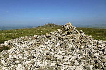
Mynydd Carningli from Newport
Pembrokeshire Coast Walk
Nat Park - Pembrokeshire Coast
County/Area - Pembrokeshire
Author - Lou Johnson
Length - 4.5 miles / 7.3 km Ascent - 1050 feet / 318 metres
Time - 3 hours 20 minutes Grade - easy/mod
Maps 

| Ordnance Survey Explorer OL35 | Sheet Map | 1:25k | BUY |
| Anquet OS Explorer OL35 | Digital Map | 1:25k | BUY |
Walk Route Description
Click image to see photo description.
This short hill walk from Newport (Pembrokeshire) explores the rugged hill of Mynydd Carningli lying to the south of the town. The summit of this former volcano offers fine views north to the coast. The walk needs careful navigation as there are many paths that cross the rocky moorland landscape. However, the objective is always in view.
The start is the car park beside the estuary and sands on Parrog Road in Newport (grid ref. SN052396). After parking exit the car park and turn right along Parrog Road from where you get a pleasant view of Mynydd Carningli. Continue uphill to the A487. Turn right and the sharp left into Upper West Street. Continue ahead into Upper Bridge Street and Church Street. Pass St Mary Church on your left and continue to a fork in the road. Bear right up the lane (signed no through road) and continue uphill for 350 metres to where the lane forks (grid ref. SN059385) and bear left along a lane. Follow the lane and bear left at the first junction and continue to a fingerpost. Just past the fingerpost, turn right up a track between hedges. After 200 metres you enter open access land.
The path runs parallel with fields on your right before entering open moorland with Mynydd Carningli rising ahead. After 300 metres go straight across a path running east to west and continue steeply uphill to reach the remains of Carningli's hillfort. The path swings southwest and continues to the highest point of Carningli Common. Allow time to enjoy the superb view before starting the descent. From the summit pick your way down the slope in a northeasterly direction to re-join the path used on the outward route. All that remains in a downhill stroll back to Newport and the car park on Parrog Road.
Other walks nearby
| Walk 3474 | Dinas Island from Cwm-yr-Eglwys | easy | 3.0 miles |
| Walk 3466 | The Preseli Ridge along the Golden Road | moderate | 6.4 miles |
| Walk 3465 | Foel Eryr Circular, Preseli Hills | moderate | 6.0 miles |
| Walk 3494 | Pwllygranant & Cebwr Bay from Moylgrove | mod/hard | 8.5 miles |
| Walk 3469 | Foel Cwmcerwyn from Rosebush, Preseli Hills | moderate | 5.0 miles |
| Walk 3468 | Foel Drygarn Hillfort, Preseli Hills | easy | 1.8 miles |
| Walk 3467 | Foel Drygarn Hillfort circular, Preseli Hills | easy/mod | 3.7 miles |
| Walk 3490 | Cemaes Head & Clawddcam from Poppit Sands | moderate | 8.3 miles |
| Walk 3491 | Cwm yr Esgyr & Cemaes Head from Poppit Sands | moderate | 6.1 miles |
| Walk 3479 | Strumble Head & Garn Fawr Hillfort | moderate | 6.8 miles |
Recommended Books & eBooks
The Wales Coast Path
 A single guidebook to walking the whole Wales Coast Path - 1400km (870 miles) the length of Wales from Chester to Chepstow, including Anglesey, described in 57 stages. The route passes through the Snowdonia and Pembrokeshire National Parks and many AONBs and can be linked with the Offa's Dyke Path for a complete circuit of Wales.
More information
Messaging & Social Media
Message Walking Britain and follow the latest news.

Mountain Weather
Stay safe on the mountains with detailed weather forecasts - for iOS devices or for Android devices.