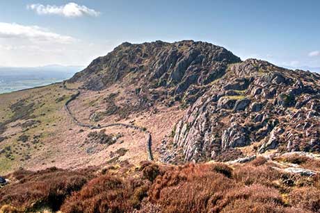
Moel-y-Gest Porthmadog
Llyn Peninsula Walk
Region - Llyn Peninsula
County/Area - Gwynedd - Llyn Peninsula
Author - Lou Johnson
Length - 2.5 miles / 4.1 km Ascent - 800 feet / 242 metres
Time - 2 hours 0 minutes Grade - easy/mod
Maps 

| Ordnance Survey Explorer OL18 | Sheet Map | 1:25k | BUY |
| Anquet OS Explorer OL18 | Digital Map | 1:25k | BUY |
Walk Route Description
Click image to see photo description.
Starting from Porthmadog, this short walk explores the twin summits of Moel-y-Gest (Pen Llŷn) which lie west of the town centre. The route can involve some scrambling, but this is avoidable as the hill has many paths which offer easier options. The steep climb onto the hill is rewarded with a glorious panorama which includes the coast south to Harlech and west towards Criccieth. Inland some of the higher mountains of Eryri (Snowdonia) including the Moelwyns and Yr Wyddfa (Snowdon) can also be seen.
The start is the Lidl car park (grid ref. SH564390) alongside the A497 northwest of the town centre where parking is available if you purchase something from the store. After parking return to the A497 and turn right. Cross the road when convenient and continue to reach a footpath fingerpost on the left. Veer left up the path into woodland. The path soon heads half-left to climb across the eastern flank of Moel-y-Gest (Pen Llŷn). Pass through the gateposts and continue upwards to cross a stile in a wall (grid ref. SH558389).
After crossing the stile, turn left and follow the path beside the wall out of the trees. Join the clear path heading up the ridge which climbs steeply to reach the top. You soon cross the east top of Moel-y-Gest/Pen Llŷn (231 m.) from where you descend to a col. The route continues west where there are options for scrambling if you prefer. Continue to the west top (262 m.) which is marked with an OS trig column. The view is superb, and you should allow time to absorb the many features before retracing your steps back to the start.
Other walks nearby
| Walk 3383 | Morfa Bychan from Borth-y-Gest | easy | 4.0 miles |
| Walk 2336 | Moel-y-Gest | easy/mod | 3.8 miles |
| Walk 3370 | Criccieth & Llanstumdwy Circular | easy | 4.5 miles |
| Walk 1173 | Moel Ysgyfarnogod & Foel Penolau | moderate | 6.5 miles |
| Walk 1127 | Cnicht | moderate | 6.3 miles |
| Walk 3035 | The Moelwyns | mod/hard | 7.5 miles |
| Walk 1010 | Cnicht, Moel Druman & Allt-fawr | moderate | 10.0 miles |
| Walk 1422 | Cnicht and Moelwyn Mawr | moderate | 8.0 miles |
| Walk 2150 | Llyn Dinas and Cwm Bychan from Beddgelert | easy/mod | 6.0 miles |
| Walk 2560 | Moel Hebog, Moel yr Ogof & Moel Lefn from Beddgelert | mod/hard | 6.5 miles |
Recommended Books & eBooks
Snowdonia: 30 Low-level and easy walks - South
 Guidebook describing 30 walks in Snowdonia, Wales. Routes are mostly low level and on clear paths and showcase the region's beautiful scenery and rich history and culture. Part of a 2-volume set, this southern volume includes Trawsfynydd, Bala, Dolgellau, Machynlleth, the Harlech Coast and the valleys of the Mawddach and Dyfi.
More information
Snowdonia: 30 Low-level and easy walks - North
 Guidebook describing 30 walks in Snowdonia, Wales. Routes are mostly low level and on clear paths and showcase the region's beautiful scenery and rich history and culture. Part of a 2-volume set, this northern volume includes the Snowdon area, the Ogwen and Conwy Valleys, Betws-y-Coed, Beddgelert, Ffestiniog and the coast.
More information
Messaging & Social Media
Message Walking Britain and follow the latest news.

Mountain Weather
Stay safe on the mountains with detailed weather forecasts - for iOS devices or for Android devices.