St. Agnes to Porthtowan
Cornwall AONB Walk
Region - Cornwall AONB
County/Area - Cornwall
Author - Lou Johnson
Length - 5.0 miles / 8.1 km Ascent - 900 feet / 273 metres
Time - 3 hours 20 minutes Grade - easy/mod
Maps 

| Ordnance Survey Explorer 104 | Sheet Map | 1:25k | BUY |
| Anquet OS Explorer 104 | Digital Map | 1:25k | BUY |
Walk Route Description
Click image to see photo description.
This walk from St. Agnes to Porthtowan explores a section of the North Cornwall coast following the South West Coast Path (SWCP). The easy-to-follow route offers excellent views along the rugged coast and the chance to explore the clifftop buildings of Wheal Coates (NT), a former tin mine. The start of the walk is the main car park at Porthtowan Beach (Grid ref. SW693480) and uses route 315 bus to reach St Agnes. The service is limited but convenient and does not operate on Sundays.
After parking walk south along Beach Road to the T-junction and turn left along Rose Hill. The bust stop is a short way along this road on the left. Stay on the bus to St Agnes and alight by the St Agnes Hotel opposite the parish church. Bear left up Trevaunance Lane and turn right down Rocky Lane (signed to the Beach). Ignore the first footpaths, signed left and right, and continue down towards the sea and turn left onto the SWCP signed to Chapel Porth. You soon join a lane and pass above Trevaunance Cove and continue up steps to the headland.
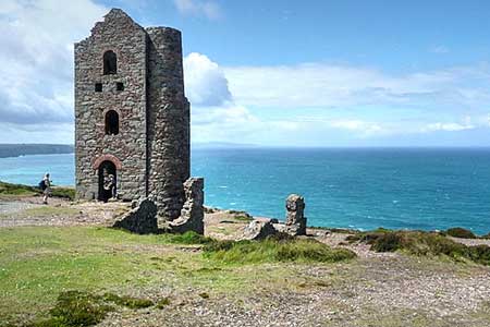
Continue along the SWCP soon passing a series of disused quarries on your left. From here the path continues to St. Agnes Head. The path turns south past a lookout station and continues along the cliff tops to Reach Wheal Coates where time should be allowed for exploration of this interesting site. Return to the SWCP and continue south using the acorn waymarks as a guide. . Descend the steep path down to the car park at Chapel Porth where there are refreshments in season. Walk to the right of the beach café and cross a small bridge. The path initially heads inland but soon turns sharp right to regain the clifftops. You pass the remains of Wheal Charlotte which lie off the main path to the left. Approaching Porthtowan, you have a fine view over the beach before dropping down to the car park.
Other walks nearby
| Walk 2267 | Godrevy Point & Hell's Mouth | easy/mod | 5.2 miles |
| Walk 2003 | Cowlands, Coombe & Roundwood Quay from Trelissick | easy/mod | 9.0 miles |
| Walk 1104 | Newquay to Porthcothan coast path | moderate | 10.5 miles |
| Walk 2206 | St. Ives - a town stroll | easy | 1.5 miles |
| Walk 2007 | Helford Passage & Frenchman's Creek | easy/mod | 7.0 miles |
| Walk 2088 | Rosemullion Head & Mawnan | easy | 4.0 miles |
| Walk 1027 | Nare Head & Portloe | moderate | 7.0 miles |
| Walk 2208 | Marazion - a town stroll | easy | 1.0 miles |
| Walk 1081 | Zennor & St Ives coast path | mod/hard | 11.0 miles |
| Walk 1223 | Morvah to Zennor coast | moderate | 5.5 miles |
Recommended Books & eBooks
The South West Coast Path
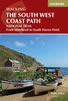 Guidebook to walking the entire South West Coast Path National Trail. The route runs for 630 miles from Minehead to Poole along the north Devon, Cornish, south Devon and Dorset coastline. Divided into 45 stages, this long-distance coastal trek could be completed within 4 weeks, or walked in sections. Guide includes maps and essential information.
More information
South West Coast Path Map Booklet - St Ives to Plymouth
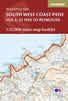 Map of part of the southern section of the 630 mile (1014km) South West Coast Path National Trail. Covers the trail from St Ives to Plymouth along the west Cornwall and Devon coastline. This convenient and compact booklet of Ordnance Survey 1:25,000 maps shows the route, providing all of the mapping you need to walk the trail in either direction.
More information
Messaging & Social Media
Message Walking Britain and follow the latest news.

Mountain Weather
Stay safe on the mountains with detailed weather forecasts - for iOS devices or for Android devices.