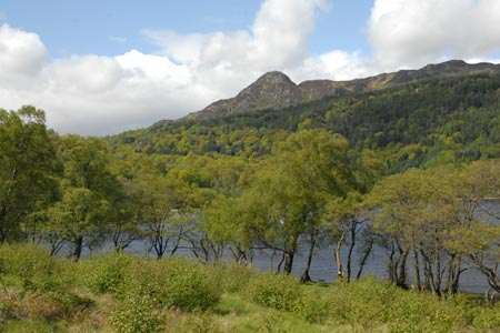
Ben A'an from Loch Achray
Loch Lomond and Trossachs Walk
Nat Park - Loch Lomond and Trossachs
County/Area - Stirling
Author - Lou Johnson
Length - 2.5 miles / 4.1 km Ascent - 1150 feet / 348 metres
Time - 2 hours 20 minutes Grade - easy/mod
Maps 

| Ordnance Survey Explorer OL46 | Sheet Map | 1:25k | BUY |
| Anquet OS Explorer OL46 | Digital Map | 1:25k | BUY |
| Ordnance Survey Landranger 57 | Sheet Map | 1:50k | BUY |
| Anquet OS Landranger 57 | Digital Map | 1:50k | BUY |
Walk Route Description
Click image to visit gallery of 9 images.
The relatively minor summit of Ben A'an (454m) offers some astounding views. If views could be measured then this short walk could possibly provide more quality views per mile walked than many other longer and more arduous excursions.
The start is a small car park (grid ref. NN509070) on the A821 which heads west from the A84 near Callander. The drive offers views of Lochs Venachar and Achray, with the parking area on your left just after the road skirts the latter loch.
After parking cross the road and follow the well engineered path as it climbs initially through forest. The going in places is quite steep and care needs to be taken when walking across tree roots as these seem to be super-slippery after rain. Eventually the path leaves the trees and you get your first clear view of the hill you are climbing.
With the end of the trees the path changes in character and includes a section of steeper ascent through a rocky cleft before the gradient eases again once the more open hillside is reached. From here a great sweep takes you to the summit area from where the magnificent panorama is based on the foreground view Loch Katrine, which can seen almost in its entirety. The backdrop is made up of many mountains, including a good number of Corbetts and Munros, in a great arc from the south to the northwest.
After enjoying the view the best way down is to retrace your steps. However it is possible to drop down on a small path that starts from the main path about 120 metres north of the summit. However a brief 'recce' of this path found it very wet and boggy. With the prospect of a steep descent through forest to the road it was decided that the easy way down was the better option.
Other walks nearby
| Walk 2413 | Ben Venue from Loch Achray | moderate | 8.2 miles |
| Walk 1350 | Ben Ledi from near Falls of Leny | moderate | 5.5 miles |
| Walk 3647 | Callander, Samson's Stone & Coilhallan Wood | easy | 4.7 miles |
| Walk 2418 | Inverlochlarig, Beinn a'Chroin & Beinn Chabhair | hard | 12.5 miles |
| Walk 1493 | WHW - Day 3 - Rowardennan to Inverarnan | moderate | 14.0 miles |
| Walk 3009 | Ben Lomond | mod/hard | 7.5 miles |
| Walk 2659 | Conic Hill | easy/mod | 4.0 miles |
| Walk 1492 | WHW - Day 2 - Dryden to Rowardennan | moderate | 15.0 miles |
| Walk 2185 | Ben Vorlich from Loch Earn | moderate | 6.0 miles |
| Walk 2317 | Ben Vorlich from Ardlui | mod/hard | 6.8 miles |
Recommended Books & eBooks
Walking Loch Lomond and the Trossachs
 A guide to walking and scrambling routes in the beautiful Loch Lomond and the Trossachs National Park. Over 70 graded low-level, mid-level and mountain walks taking in hills, glens and picturesque woodland, as well as all of the region's Munro summits. Highlights include Ben Lui, Ben Lomond, the Cobbler and the Arrochar Alps.
More information
Messaging & Social Media
Message Walking Britain and follow the latest news.

Mountain Weather
Stay safe on the mountains with detailed weather forecasts - for iOS devices or for Android devices.