The Cloud from Rushton Spencer (short route)
Staffordshire Walk
County/Area - Staffordshire - North Staffordshire
Author - Lou Johnson
Length - 5.0 miles / 8.1 km Ascent - 600 feet / 182 metres
Time - 3 hours 10 minutes Grade - easy/mod
Maps 

| Ordnance Survey Explorer 268 | Sheet Map | 1:25k | BUY |
| Anquet OS Explorer 268 | Digital Map | 1:25k | BUY |
| Ordnance Survey Landranger 118 | Sheet Map | 1:50k | BUY |
| Anquet OS Landranger 118 | Digital Map | 1:50k | BUY |
Walk Route Description
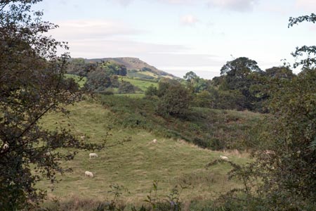
Click image to visit gallery of 12 images.
The Cloud is a gritstone promontory in North Staffordshire that many recognise but cannot name. From its summit wide views across the Cheshire Plain and the Cheshire and Staffordshire Moorlands that lie within the Peak District National Park can be enjoyed. This linear walk follows an out and back route starting from the village of Rushton Spencer.
The start is a small car park (grid ref. SJ936624) on the Staffordshire Way beside the Knot Inn which is reached off the A523 Leek to Macclesfield road. Note the car park is not the pub car park and actually lies on the of railway track bed that forms the long distance footpath in this area. After parking walk back to the road passing the old station to continue along the Staffordshire Way in a north westerly direction.
After about a kilometre you reach a footpath sign on your left (grid ref. SJ930633). Descend and follow this signed path across meadows to follow the River Dane for a short section. Soon the path enters Ravensclough Wood. Continue through the wood which almost fills Ravensclough to reach an access road to a farm. Turn left up this lane to bearing right at a junction. So after take the signed footpath on your left (grid ref. SJ916635). Take this path across the hillside with improving views of The Cloud ahead.
Reaching a lane (grid ref. SJ907636)turn left and continue up the lane to reach a footpath on your right. This leads without further problem apart from the steep initial section onto the moorland surrounding the trig point that marks the highest point of the The Cloud. The return route follows the outward route although it is worth noting that views ahead certainly in the first half of the descent are excellent.
Other walks nearby
| Walk 1288 | Roaches & Hen Cloud from Tittesworth Reservoir | moderate | 8.5 miles |
| Walk 1178 | Roaches and Lud's Church | moderate | 7.3 miles |
| Walk 1707 | The Roaches short circular | easy/mod | 5.0 miles |
| Walk 3030 | Roaches & Lud's Church | easy/mod | 7.0 miles |
| Walk 2577 | Hawk's Nest, Goldstitch Moss & Lud's Church | moderate | 8.0 miles |
| Walk 1596 | Lud's Church and Roach End from Gradbach | easy/mod | 4.5 miles |
| Walk 1598 | Lud's Church, Back Forest & Clough Head | easy/mod | 6.8 miles |
| Walk 3323 | Gradbach, Three Shires Head & Knotbury | easy/mod | 7.1 miles |
| Walk 3197 | Flash, Knotbury & Three Shires Head | easy/mod | 8.2 miles |
| Walk 1371 | Rossendale Ramble from Sutton | moderate | 12.0 miles |
Recommended Books & eBooks
Walking in the Peak District - White Peak East
 Guidebook describing 42 half-day and day walks in the limestone landscapes of Derbyshire's White Peak, part of the Peak District National Park. One of two volumes, this book covers the east of the region, with potential bases including Bakewell, Eyam, Castleton, Birchover, Matlock and Wirksworth.
More information
Messaging & Social Media
Message Walking Britain and follow the latest news.

Mountain Weather
Stay safe on the mountains with detailed weather forecasts - for iOS devices or for Android devices.