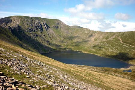
Red Tarn & Birkhouse Moor from Glenridding
Lake District Walk
Nat Park - Lake District - Lake District Eastern Fells
County/Area - Cumbria
Author - Lou Johnson
Length - 6.0 miles / 9.8 km Ascent - 2000 feet / 606 metres
Time - 5 hours 0 minutes Grade - moderate
Maps 

| Ordnance Survey Explorer OL5 | Sheet Map | 1:25k | BUY |
| Anquet OS Explorer OL5 | Digital Map | 1:25k | BUY |
Walk Route Description
Click image to see photo description.
Visiting one of the major summits of the Lake District is often the objective of a walk. However lower-level walks can often offer equally scenic walking as in the case of this route to Red tarn below Helvellyn. The walk offers some views of the high peaks, excellent walking and immersion in beautiful Lakeland scenery all typical of many Lake District walks.
The start is Glenridding on the shores of Ullswater where a large pay and display car park is located on the west side of the A592 (grid ref. NY386169). After parking exit the car park and turn right over Glenridding Beck. Turn first right in front of the shop following the bridleway to Helvellyn. Continue along the bridleway bearing right at the first junction towards Gillside. The bridleway continues with the Beck on your right-hand past a campsite to reach a lane (grid ref. NY386169).
Turn left, walking uphill to Helvellyn via Miresbeck. Ignore the path on the right to Greenside and continue to a path junction (grid ref. NY377167). Turn right and continue climbing to a stile (grid ref. NY376166). Turn right and, with the intake wall on your right, continue up Glenridding. The path ahead is well trodden and, after a level section by the intake wall, turn southwest and climb steadily past a sheepfold (grid ref. NY357168) and up beside Red Tarn Beck to Red Tarn (grid ref. NY350154).
After enjoying the magnificent surroundings of Red Tarn which includes Catstye Cam, Helvellyn, Swirral Edge and Striding Edge take the path heading east from the Tarn out-flow to the Hole-in-the-Wall (grid ref. NY359155). Turn left along the wall (wall to your right) and continue straight ahead to reach the cairn on Birkhouse Moor (grid ref. NY365164) from where you can enjoy a wide panorama of the surrounding fells and much of the route you have just undertaken.
To continue, retrace your steps back to the main path and turn left, again keeping the wall on your right. After about 600 metres beside the wall turn left at a large cairn to descend quite steeply into Little Cove where you re-join the outward route at a stile (grid ref. NY376166). From here retrace your steps back to the start.
Other walks nearby
| Walk 1230 | Birks & Arnison Crag | moderate | 5.5 miles |
| Walk 1520 | Helvellyn & Fairfield Horseshoe from Patterdale | very hard | 13.0 miles |
| Walk 2047 | Place Fell from Patterdale | moderate | 7.5 miles |
| Walk 2425 | Boredale Circular from Patterdale | mod/hard | 11.5 miles |
| Walk 3670 | Angle Tarn and Hayeswater | moderate | 8.3 miles |
| Walk 1110 | Angletarn Pikes | moderate | 7.0 miles |
| Walk 2060 | The Angletarn Pikes and Brock Crags from Hartsop | moderate | 8.0 miles |
| Walk 3388 | Hayeswater and Angle Tarn from Hartsop | mod/hard | 11.5 miles |
| Walk 2386 | Red Screes via Dove Crag | mod/hard | 8.6 miles |
| Walk 2039 | Gowbarrow Fell circular | moderate | 3.5 miles |
Recommended Books & eBooks
Lake District: Low Level and Lake Walks
 This guidebook describes 30 of the best low-level walks in the Lake District. From delightful wooded glades and sparkling tarns, to waterfalls and glacier-carved valleys towered over by craggy mountains. The walks described aim to seek out the best walking that the lower areas of the Lake District have to offer.
More information
Great Mountain Days in the Lake District
 An inspirational guidebook to 50 challenging walks on the high fells of the Lake District. The graded circular routes, between 4 and 14 miles in length, cover classic Lakeland summits like Fairfield, Scafell Pike, Great Gable and Blencathra, to the lesser-known High Spy, King's How and Brund Fell.
More information
Messaging & Social Media
Message Walking Britain and follow the latest news.

Mountain Weather
Stay safe on the mountains with detailed weather forecasts - for iOS devices or for Android devices.