Walk 2346 - printer friendly version
Yr Orsedd ridge from near Bont Newydd Walk
Author - Lou Johnson
Length - 4.8 miles / 7.8 km
Ascent - 1400 feet / 424 metres
Grade - moderate
Start - OS grid reference SH676716
Lat 53.2248960 + Long -3.9847012
Postcode LL33 0EH (approx. location only)
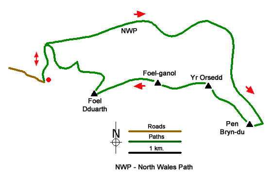
The Yr Orsedd ridge, with four minor summits, offers a short but energetic walk in the Northern Carneddau. The route follows good tracks for much of the way although once on the ridge paths are feint and a good sense of direction is required. The area covered is littered with ancient cairns which are marked on the relevant OS map. Once on the ridge the views inland include some higher peaks of the Carneddau. Looking north the panorama includes the Menai Straits and Anglesey.
The start is a small parking area (grid ref. SH676716) at the end of the lane from the A55 at Abergwngregyn that heads inland through past Aber Falls. After parking exit the car park and follow a path with a wall on your left. Pass through a metal kissing gate and continue ahead beside the wall to join a track. Continue up the track and bear right under the power lines.to continue along the North Wales Path. After two kilometres of steady uphill walking, you reach a track junction with a four-way fingerpost (grid ref. SH693722).
Turn right, signed to Drum, and follow the rising track. As you climb, the Yr Orsedd ridge rises on your right with final top of Pen Bryn-du (557 m.) being the first objective. At a suitable point, near where the shoulder starts to lose height, bear right off the track and follow sheep trods up to the rocky summit of Pen Bryn-du from where the next objective, Yr Orsedd (559 m.), is in view. Head along a grassy path initially northwest, descend to a shallow col, and head uphill to the summit ridge. Follow the crest of the ridge across Yr Orsedd, descend to a col and climb to the summit of Foel-ganol (536 m.). This top, in my opinion, offers the best view.
A steepish descent leads down to a col and short ascent onto the final top of the ridge, Foel Dduarth (approx. 440 m.). The south face of the ridge has some crags, so the best line of descent is to leave Foel Dduarth in a north-easterly direction. As you descend across the face of the hill you can see a substantial sheep pen below. This is the next objective. Maintaining the northeast trend, you will soon meet a path descending towards the sheep pen. Turn left, downhill, and continue to the left of the pen. After passing the pen, you reach a clear path Turn left and continue down to a track (grid ref. SH678717). Turn right and drop down to the power lines from where you retrace your steps to the start.
Messaging & Social Media
Message Walking Britain and follow the latest news.

Mountain Weather
Stay safe on the mountains with detailed weather forecasts - for iOS devices or for Android devices.