Cuckoo Walk & Bacon Butties from Marsden
South Pennines Walk
Nat Park - Peak District - Black Hill Dovestone
Region - South Pennines
County/Area - West Yorkshire & Greater Manchester
Author - Stephen Starkey
Length - 19.5 miles / 31.7 km Ascent - 2970 feet / 900 metres
Time - 12 hours 40 minutes Grade - hard
Maps 

| Ordnance Survey Explorer OL1 | Sheet Map | 1:25k | BUY |
| Anquet OS Explorer OL1 | Digital Map | 1:25k | BUY |
| Ordnance Survey Explorer OL21 | Sheet Map | 1:25k | BUY |
| Anquet OS Explorer OL21 | Digital Map | 1:25k | BUY |
| Ordnance Survey Landranger 110 | Sheet Map | 1:50k | BUY |
| Anquet OS Landranger 110 | Digital Map | 1:50k | BUY |
Walk Route Description
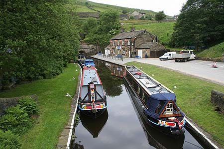
Click image to visit gallery of 6 images.
This Peak District walk from the South Pennine village of Marsden is a tough day out in the wild moors. There are a number of options available to shorten the route, some of which are described in the text. One of the perks of this route is the opportunity to boost the flagging energy levels by sampling some of the best bacon butties available anywhere.
The route takes in, amongst other things, a bit of canal walking, an old pack horse route, a few sections of the current Pennine Way route, a bit of the original Pennine Way.
Before describing the route, some words of warning :
The section from Black Moss Reservoir to Black Hill follows the original Pennine Way route. The path looks obvious on the OS map, however, for most of the year, this is serious peat bog country and the path is often invisible on the ground. In poor visibility, this is not the place to find out your navigational skills are not as good as you thought !
At the time of writing (June 2006), the section of the Pennine Way crossing the Wessenden Valley (used for one of the shorter alternative routes) is closed following a number of landslides making the path unsafe. An alternative route is signposted on the ground but this is not a path marked on the OS maps of the area.
The route starts out from Marsden railway station (Grid ref. SE046118). There are hourly train services Monday to Saturday from Huddersfield and Manchester Piccadilly; less frequent on Sunday. Bus route 352 from Huddersfield also stops at Marsden station. Bus routes 350 and 351 from Huddersfield also go to Marsden (but not the station), route 184 between Huddersfield and Manchester stops near the centre of the village. Car parking is available at the old railway goods yard, signposted as parking for Standedge Visitor Centre.
From the railway station / goods yard, join the tow path alongside Huddersfield Narrow Canal and head in a Westerly direction until reaching the basin at the visitor centre. This is very close to the Marsden end of the Standedge Canal Tunnel - the longest and highest canal tunnel in Britain.
From here, cross the canal by means of the stone bridge then head North along the access road until reaching the minor road next to The Tunnel End Inn (Grid ref SE040121). Turn left along the minor road (Waters Road), with a number of houses on the right and the disused Tunnel End Reservoir on the left. There is no footpath along this road but a purpose built gravel path within the old reservoir is currently nearing completion. Despite growing up in Marsden, I can't offer any more information on this path -I've not yet worked out where the access points on and off this path are / will be.
When arriving at the "junction" at the end of Waters Road (Grid ref. SE031122), there is the entrance to Hey Green Restaurant on the right, a bridge over the river leading to a Private Road on the left and a narrow tarmac lane continuing ahead. Take the narrow lane, climbing gently, as far as Eastergate Cottage on the right. At this point a waymarked footpath leads off to the left through a gate. After rain, the next 200m or so are very wet, muddy and slippery underfoot.
The 'river' on the left is the infant River Colne. 30 years or so ago, this was a vibrant, beautiful river popular with locals for river swimming / paddling. The construction of the nearby Scammonden Reservoir and the subsequent pipework etc. installed to divert water to the reservoir have reduced this river to a minor stream nowadays.
Follow the path alongside the river and then across the river via the pack horse bridge, marked on the OS maps as Close Gate Bridge. This is probably the most photogenic of a number of similar bridges in the area. Such bridges were deliberately built with low side walls to ensure that the packs predominantly laden with wool (if going from Yorkshire to Lancashire) or cotton (if going from Lancashire to Yorkshire) carried by the pack horses would clear the bridge walls without the need to unload from the horses.
After crossing the bridge, do NOT follow either of the obvious paths up the two valleys. The required path goes up the short sharp climb ahead. Although overgrown in a few areas, the path can be picked out from below. After the initial short steep section, the path becomes more obvious and the gradient negligible as the route follows the old Packhorse Road, passing close to March Haigh Reservoir and on to meet the Pennine Way at the A640 road (Grid ref. SE002122), a place known locally as Buckstones.
The route of the Packhorse Road was the subject of a long legal battle between the local council and landowners in the 1700's - more information about the dispute can be found at www.marsdenhistory.co.uk for those who are interested. When you see the rough moorland, it is difficult to imagine why the dispute was so bitter. Apparently the difficulties of getting landowners to grant public access to the open moors of England go back a few hundred years at least.
Although March Haigh reservoir is not sealed off in any way, before being tempted to "have a paddle", you should be aware that this reservoir has the reputation for having the coldest water in Yorkshire. Having personally sampled the upper reaches of a number of rivers in the Dales and knowing how cold they can be, I've never been willing to test March Haigh's reputation.
From the path junction at Buckstones, double back left, across the short section of duck boards, on to the Pennine Way, heading in a predominantly Westerly direction. This section of the Pennine Way is now a well maintained gravel path, making for easy going to the Trig Point at the top of Millstone Edge. If you are fortunate enough to do this walk on a clear day, the views from the edge over Lancashire are extensive, taking in the villages and valleys of Saddleworth and the conurbations of Oldham, Rochdale and Manchester.
Continue heading West along the Pennine Way from Millstone Edge, descending gradually to an awkward stile over a fence where the Pennine Way merges with the Pennine Bridleway. At this junction, turn left for the short walk to the point where the Pennine Way crosses the A62 at the Standedge Cutting (Grid ref. SE018095) next to Brun Clough reservoir and a small parking area. From here, if necessary, you could turn left [North] (up hill initially) and walk besides the A62 back to Marsden. The main route crosses the A62 then follows the waymarked Pennine Way to the left up the stepped path.
The path once again heads across wild, open moorland, occasionally passing between enclosures erected by the National Trust, but with views towards Marsden and the Colne Valley to the left. The path passes to the South of Redbrook Reservoir, a small reservoir often used by sailors before coming to a small brook (Grid ref. SE027095) which is incredibly boggy even in a drought. The path splits at this point, a grassy path being visible ahead is the Standedge Trail, the path to follow turns right, still being the Pennine Way. The path climbs very gently again across the moor and leads to Black Moss Reservoir. The current Pennine Way route turns to the left just before this reservoir but we continue ahead on the path across the reservoir dam, this path being the original route of the Pennine Way. For those wanting a shorter route, rather than crossing the dam, continue to follow the Pennine Way to the Wessenden Valley where you rejoin the main route, but take note of the second warning at the top of the route description regarding a closure of the path and signed diversion.
This "path" is now followed until reaching the A635 Holmfirth - Greenfield road at SE051063. Care is needed in places on this section as the path isn't always visible and it can be very boggy in places. Serious erosion of the peat in this area was one of the major reasons for the route of the Pennine Way being changed. This re-routing of the Pennine Way has helped the recovery of the moors in this area as the bogs are nowhere near as bad as they were in the early 1980's.
On reaching the A635, the public footpath across the road that is marked on the OS maps does not appear to exist today. You could try following the line of the fence but the ground looks extremely un-inviting. Far easier is to turn left along the road for about 250m to where a path leads off right from the road between two large concrete blocks that once supported a mains pipe of some description. From here you could shorten the route by continuing along the A635 to it's junction with Wessenden Head Road at grid ref. SE076073.
However, for the main route, turn right on to the path between the concrete blocks. This leads on to the open moor, following the original Pennine Way route once again. This section of the route is serious peat bog country, the path is often either invisible or heads straight in to the middle of big bogs. It is often possible to walk safely across these bogs in January / February when they are frozen solid. At other times of year it is essential to be proficient and confident in the use of map and compass and also to have adequate navigational skills to "detour around obstructions" safely. Although this section does not involve any steep climbs nor any significant gain in altitude, the nature of the terrain make it physically demanding. If in doubt about your abilities, the sensible thing is not to tackle this section of the walk. Periodically you will see posts in the ground with the Acorn symbol to identify a National Trail. Although the Pennine Way no longer comes across this moor, these remains from previous times are extremely useful navigational aids.
The 'path' eventually leads to the Trig Point at the summit of Soldiers Lump (Grid ref. SE077047), aka Black Hill - a more appropriate name is hard to imagine. The photo of the Black Hill Trig Point published with this walk was taken on 24 June 2006. The 'cairn' surrounding the trig point is just over 1m high. The first time I walked to the summit of Black Hill in the mid 1970's, the cairn wasn't there - the peat came up to the base of the trig point column. That gives some idea of the rate of erosion of the peat on these moors.
From Soldiers Lump / Black Hill's summit, the going underfoot gets much easier. Head off in a NNE direction on the 'new' Pennine Way route, following the stone flagged path. The views over the Holme Valley and Huddersfield are quite impressive. This path leads easily back to the A635 near it's junction with the Wessenden Head Road. You won't be able to fail to notice the difference between walking the original Pennine Way route and the current Pennine Way route ! Having regularly walked these moors for the last 30+ years, I much prefer the challenge posed by walking the terrain of the original route rather than the current option of a route molly-coddling the jeans, trainers and fair weather brigade.
A small caravan will inevitably be parked up in the lay-by just along the road. This is Snoopy's Snack Bar, purveyor of the best (and biggest) Bacon Butties I have ever experienced, anywhere. The size of the mugs of tea rival those of the famed Pete's Eats in Llanberis.
From the road junction, follow the Wessenden Head Road for approx 400m to grid ref. SE076076 where the Pennine Way heads off to the left on a really obvious track with substantial metal gates installed to prevent unauthorised vehicular access. The leg weary can shorten the route by turning left on to this track and following it down the full length of the Wessenden Valley, passing a series of 4 reservoirs. To follow the main route, continue along the road to grid ref. SE081088 where a permissive path cuts back to the left, crossing 2 or 3 stiles and climbing to the summit of West Nab with extensive views over Huddersfield and its environs. On a clear day the views will open up as far as the Ferrybridge and Drax power stations near Selby.
From the summit of West Nab, head on a bearing of 262 to Raven Rocks then pick out a route on a bearing of about 250 to descend to Little Hey Sike Clough then walk alongside the stream to meet the Pennine Way path alongside Wessenen Reservoir. On the descent from West Nab, it may be necessary to locate stiles to cross fences periodically erected by the National Trust to create enclosures on the moor.
On reaching the Wessenden Valley path, turn right (North West) and follow the path alongside Wessenden, Blakeley and Butterley reservoirs to meet the road at grid ref. SE048107. This section is quite pretty in late May / June when the rhododendrons are in full bloom.
A small tea room has opened at Wessenden Lodge, between Wessenden and Blakeley reservoirs. A small herd of deer are also kept at the Lodge. Whether or not you agree with keeping such animals in this environment, children are thrilled at the inquisitive and friendly nature of this particular herd of deer.
From the point where the Wessenden Valley path meets the minor road, there is a choice of routes. You can either follow the road or you can head left through the remains of a wooden gate and descend 150+ steps to follow a path through the mill complex. Both routes meet again at the roundabout at the Fall Lane / Mount Road / Binn Road junction next to Marsden Football Club.
From the roundabout, head down Fall Lane alongside the football club, bearing left to pass under the bridge. If you fork right after the bridge, you will come to the centre of the village with a number of hostelries, including The Riverhead which brews it's own range of beers. Taking the left fork after the bridge will lead you past Marsden Parish Church and round to Station Road where turning left leads back to the station and goods yard car park.
Other walks nearby
| Walk 2613 | Boundary Walk from Marsden | moderate | 13.0 miles |
| Walk 1587 | Scammonden Reservoir | easy | 4.0 miles |
| Walk 2561 | Digley & Ramsden Reservoirs from Wessenden Head | moderate | 9.5 miles |
| Walk 2719 | Huddersfield's green fringe | easy/mod | 10.0 miles |
| Walk 2518 | Black Hill & Four Reservoirs from near Wessenden Head | moderate | 10.0 miles |
| Walk 1586 | Blackmoorfoot Reservoir | easy | 1.5 miles |
| Walk 2914 | The Pots & Pans from Uppermill | easy/mod | 4.5 miles |
| Walk 2634 | Broadstone Hill & the Cotton Famine Road | moderate | 7.0 miles |
| Walk 1583 | Digley Reservoir | easy/mod | 5.0 miles |
| Walk 1091 | Ripponden and the Calderdale Way | easy/mod | 6.5 miles |
Recommended Books & eBooks
The Pennine Way
 Guidebook to the Pennine Way National Trail with OS map booklet. The 265 mile route from Edale to Kirk Yetholm takes three weeks to walk and is suitable for fit and experienced long distance walkers. The route crosses the Peak District, Yorkshire Dales and North Pennines National Parks. Includes separate OS 1:25,000 map booklet of the route.
More information
Dark Peak Walks
 Guidebook to 40 walks in the Dark Peak area of the Peak District National Park. 35 circular routes for most abilities, from 8km to 19km, around Edale, Marsden, Fairholmes, Baslow and Castleton, including Kinder Scout and Mam Tor, and 5 longer (25km to 45km) routes highlighting the best of the Gritstone Edges, High Moorland and Deep Valleys.
More information
Messaging & Social Media
Message Walking Britain and follow the latest news.

Mountain Weather
Stay safe on the mountains with detailed weather forecasts - for iOS devices or for Android devices.