Walk 2366 - printer friendly version
The Naze from Walton-on-the-Naze Walk
Author - Lou Johnson
Length - 6.0 miles / 9.8 km
Ascent - 200 feet / 61 metres
Grade - easy
Start - OS grid reference TM252214
Lat 51.8457510 + Long 1.2680752
Postcode CO14 8DD (approx. location only)
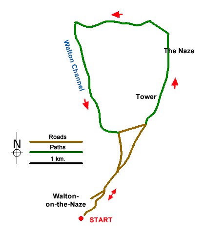
The Naze is a promontory on the Essex Coast which projects into the North Sea Near Walton-on-the-Naze. The low lying land is threatened by erosion and efforts are in place to mitigate this problem. The 18th century brick-built Naze Tower was built as a lighthouse and is open to visitors at a small charge. The view from the top covers the whole of this walk.
The walk starts from Walton-on-the-Naze railway station (grid ref. TM252214) which is served by trains from London Liverpool Street. If arriving by car, parking is available by the Tower (grid ref. TM254235) with a reduction of three miles in the length of the walk. Leave the station and turn right along the Parade and continue to reach the seafront by Walton Pier. Continue north along the seafront with the excellent beach to your right. Where the road forks, bear right onto East Terrace, which is signed to the Maritime Museum. Reaching bollards across the road, continue ahead and walk to the end of Cliff Parade. Continue along the tarmac path to reach Naze Park Road and bear right and soon turn right into Sunny Point (grid ref. TM264231).
Ahead is the Naze Tower, which is reached after crossing a parking area (the start for those using a car). Keep to the right of the Tower and veer right to the clifftop path. The cliffs are unstable, and you should keep back from the edge as you make progress north. You soon reach the point where the path turns inland. Continue to a T-junction, turn right and right again and then shortly after walk left to resume following the cliff path. The clear path soon bends left with the John Weston Nature Reserve on your left. After another gentle left-hand bend, the path skirts Cormorant Creek on your right with the Hamford Water NNR beyond. This area is important for migrating birds in season.
Reaching a sharp left-hand bend (grid ref. TM251248), keep left and follow the path with the Wanton Channel on your right. Continue ahead for two kilometres to nearly reach a track with a caravan site beyond. Turn left onto the path initially running parallel to the track. Pass two pools on your right, follow the path as it turns right to exit onto Hall Lane (grid ref. TM258229). If you parked at The Tower turn left and follow the road back to the start. If you started from the railway station, keep ahead, and follow Hall Lane back to the seafront. Bear right and retrace your steps back to the station.
Messaging & Social Media
Message Walking Britain and follow the latest news.

Mountain Weather
Stay safe on the mountains with detailed weather forecasts - for iOS devices or for Android devices.