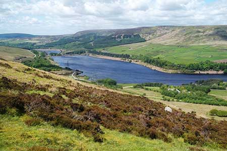
The Longendale Edges from Crowden
Peak District Walk
Nat Park - Peak District - Bleaklow Longendale
County/Area - Derbyshire
Author - Lou Johnson
Length - 11.8 miles / 19.2 km Ascent - 2400 feet / 727 metres
Time - 8 hours 20 minutes Grade - mod/hard
Maps 

| Ordnance Survey Explorer OL1 | Sheet Map | 1:25k | BUY |
| Anquet OS Explorer OL1 | Digital Map | 1:25k | BUY |
Walk Route Description
Click image to see photo description.
Longendale with its string of reservoirs is flanked by hills on either side. This walk follows the high ground on either side of the valley along the gritstone edges. The route needs careful navigation, and some sections are pathless. The rewards of the route are excellent views of Longendale and a selection of notable outcrops. This walk is for experienced walkers and the use of the relevant OS 1:25k map is recommended.
The start is the car park (grid ref. SK072992) with adjacent toilets at Crowden on the north side of the A628. After parking cross the A628 to the footpath opposite. Turn left at the first junction and continue to cross the outflow from Woodhead Reservoir to climb up to the B6105. Cross this road and follow the narrow path that angles up left to the Longendale Trail. Reaching a small parking area, leave the main trail and turn right. Shortly after, walk left to follow a clear track. After a kilometre of level walking turn right (grid ref. SK093994) signposted open country. Follow the fence, skirt the pond, ford the stream coming down Shining Clough, and continue east to reach a clear shooting track heading up Stable Clough.
Continue up Stable Clough to reach open moorland. Turn right off the track to locate a narrow but defined path along the gritstone edge above Dowstone Rocks. The path bears left around the head of Shining Clough where you may well have to head upstream to find a suitable crossing place before returning to the edge. Continue along Lawrence Edge and cross above the Rollick Stones to reach Wildboar Clough. Cross the stream and make for a stile (grid ref. SK081978). From here head south-west across pathless moorland terrain to Torside Clough and the Pennine Way. Turn right and follow this National Trail for about a kilometre before veering left (northwest) to reach Bramah Edge. Follow the path west and then southwest to reach the head of Ogden Clough. Pick up a track on the south side of this clough and continue to pass a small plantation to reach a ladder stile and the B6105.
Turn right and after 150 metres cross the stile with an adjacent fingerpost on the left and descend across fields to the Longendale Trail (grid ref. SK041975). Cross the Trail and continue to a lane. Turn right, walk between the buildings of Deepclough Farm, and continue across the dam wall of Rhodeswood Reservoir. Once across the dam, keep ahead and follow the track up to the A628. Cross the A628 slightly left to join a track which meanders uphill. Keep ahead at all junctions and you will reach a wall (grid ref. Sk045993). Pass through the wall and follow the path which runs to the right of Black Gutter (stream) for 400 metres to a path junction. Turn right and follow the edge path over Millstone Rocks to Hollins Clough and Lad's Leap.
After Lad's Leap the path crosses open moor in a southeasterly direction before following a wall (on your right). The clear path leads down to the Pennine Way. Go straight across and follow the path past Crowden Outdoor Education Centre and back to the car park.
Other walks nearby
| Walk 2625 | Torside Clough from Longdendale | moderate | 4.5 miles |
| Walk 3027 | Bleaklow Head from Longdendale | moderate | 8.0 miles |
| Walk 3174 | Saltersbrook and Lady Cross from Woodhead | easy/mod | 6.0 miles |
| Walk 1756 | Bleaklow & The Longendale Trail from Woodhead | mod/hard | 10.0 miles |
| Walk 1168 | Old Glossop & Bleaklow | moderate | 9.5 miles |
| Walk 3607 | Reservoirs Walk from Tintwistle | easy/mod | 5.5 miles |
| Walk 1759 | Torside Clough & Longendale from Old Glossop | moderate | 7.4 miles |
| Walk 1703 | Longdendale from Hadfield Station | easy/mod | 9.0 miles |
| Walk 2517 | Chew Reservoir & Fox Stone from Dovestones | moderate | 7.5 miles |
| Walk 2553 | Greenfield Reservoir & Raven Stones from Dovestone | moderate | 8.0 miles |
Recommended Books & eBooks
Walking in the Peak District - White Peak East
 Guidebook describing 42 half-day and day walks in the limestone landscapes of Derbyshire's White Peak, part of the Peak District National Park. One of two volumes, this book covers the east of the region, with potential bases including Bakewell, Eyam, Castleton, Birchover, Matlock and Wirksworth.
More information
Great Mountain Days in the Pennines
 An inspirational guidebook to 50 classic walks on the rolling Pennine landscape. The graded routes, between 6 and 13 miles in length, cover classic Pennine fells and moorland such as Whernside, Ilkley Moor and Pendle Hill; exploring the North and South Pennines, Yorkshire Dales, Howgills and Dark Peak. Many routes are also suited to fell running.
More information
Messaging & Social Media
Message Walking Britain and follow the latest news.

Mountain Weather
Stay safe on the mountains with detailed weather forecasts - for iOS devices or for Android devices.