Wye, Crundale & Wye Downs
Pub Walk + Downs Walk
County/Area - Kent
Author - Lou Johnson
Length - 8.6 miles / 14 km Ascent - 1000 feet / 303 metres
Time - 5 hours 20 minutes Grade - moderate
Maps 

| Ordnance Survey Explorer 137 | Sheet Map | 1:25k | BUY |
| Anquet OS Explorer 137 | Digital Map | 1:25k | BUY |
Walk Route Description
Click image to see photo description.
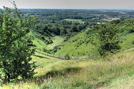
A circular walk from Wye exploring the North Dows to the east. The route follows part of the Stour Valley Walk to the isolated church at Crundale. Turning south the route crosses the Crundale Downs to join the North Downs Way for a northerly traverse of Broad Downs and Wye Downs. It is on this section that the walk passes above the Devil's Kneading Bowl a coombe cut into the escarpment. The last point of interest is the Wye Crown which was cut to celebrate the coronation of Edward VII.
The walk starts from near St Gregory and St Martin church in Wye where on-street parking is available nearby (grid ref. TR054468). It arriving in Wye by train, then it is about 600 from the station to the church. To start the walk, enter the churchyard, and follow the North Downs Way and Stour Valley Walk which keeps to the right of the church. Pass between allotments and turn right by a gate and continue to Occupation Road. Cross to the road opposite and continue onto a track along the right-hand edge of fields. Pass a path on the right and 300 metres beyond this walk half left on the Stour Valley Walk across a filed and into trees. Shortly after you reach a road (grid ref. TR066472).
Cross the road to a track slightly left. Continue to telecom mast, cross another road, and into trees. Exiting the trees turn right along the edge of the wood. The path bears left across the field. The onward path rises steeply through Beech Wood. Cross two fields to a kissing gate. Follow the path which briefly descends before rising to a metal gate (grid ref. TR075478) at Ash. Cross the byway and continue along the Stour Valley Walk. The route continues down through Marriage Wood. Leaving the trees turn left with Warren Wood above on your left and continue for 450 metres to a sunken byway just before entering trees (grid ref. TR076488). Turn right and continue ahead, cross a concrete track pass a cottage on your left. At the next signpost, turn right, cross stile on the left and head half-left up a steep slope to cross a track with St Mary's Church, Crundale, just beyond.
Turn right along the byway for nearly two kilometres passing through Towns Wood to reach a farm track (grid ref. TR087469). Cross the track to the gate opposite and continue along the right-hand edge of a field. After 600 metres you reach a sunken byway (grid ref. TR084463). Bear right and shortly after the byway bends left. Leave the byway which turns right and continue ahead beside a line of trees. Cross stile in top field corner, pass through a metal gate, cross two more stiles to a kissing gate by a copse. Cross a paddock and follow a drive left. The drive soon becomes a surfaced lane. Reaching a crossroads, go straight across and continue to pass through Cold Blow Farm and the North Downs Way (grid ref. TR087449).
Turn right along the well-waymarked National Trail soon entering Wye National Nature Reserve. Keep to the higher path along the crest of the ridge soon having a superb view into the Devil's Kneading Trough which was formed by melting ice. Continue north to a road. Cross the road to continue left along the North Downs Way. After passing the Wye Crown, the path turns right at the edge of a food and continues to a lane (Grid ref. TR072468). Turn left and after 250 metres turn left, still following the North Downs Way. The path descends through woodland and across a field. Go straight across a lane and rejoin the outward route. Continue back to Wye.
Other walks nearby
| Walk 2805 | Chilham circular from Wye | moderate | 17.0 miles |
| Walk 1044 | Wye and the Crundale Downs | moderate | 9.2 miles |
| Walk 3617 | The Wye Downs and Crundale | easy/mod | 6.0 miles |
| Walk 1353 | Pluckley village circular | easy | 3.7 miles |
| Walk 3219 | Canterbury to Whitstable | easy/mod | 10.5 miles |
| Walk 1637 | Rivers Swale & Oare | easy | 5.0 miles |
| Walk 2923 | Folkestone to Dover along the North Downs Way | easy/mod | 8.2 miles |
| Walk 3326 | Ringlestone & High Wood from Harrietsham | easy/mod | 8.0 miles |
| Walk 3521 | Wittersham to Rye (High Weald Landscape Trail) | easy/mod | 7.5 miles |
| Walk 2249 | Reculver & St Nicholas at Wade | easy/mod | 8.2 miles |
Recommended Books & eBooks
Walking in Kent
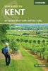 A guidebook describing 40 walks in the county of Kent. Covering west Kent and The Weald and north and east Kent, including the Kent Downs and the Greensand Hills. Walks of 5 to 9 miles explore rivers and coastline, beautiful countryside and historic villages. With outlines of 11 longer walks ranging from 15 to 163 miles.
More information
Messaging & Social Media
Message Walking Britain and follow the latest news.

Mountain Weather
Stay safe on the mountains with detailed weather forecasts - for iOS devices or for Android devices.