Farmington & Clapton-on-the-Hill
Countryside Walk + Villages
Region - Cotswolds
County/Area - Gloucestershire
Author - Lou Johnson
Length - 6.4 miles / 10.4 km Ascent - 620 feet / 188 metres
Time - 3 hours 50 minutes Grade - easy/mod
Maps 

| Ordnance Survey Explorer OL45 | Sheet Map | 1:25k | BUY |
| Anquet OS Explorer OL45 | Digital Map | 1:25k | BUY |
Walk Route Description
Click image to see photo description.
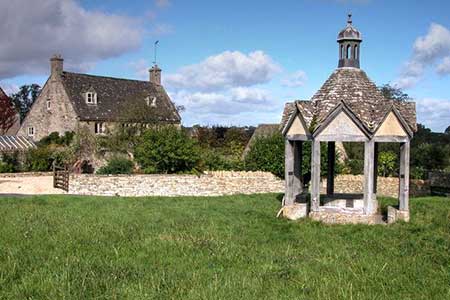
Cotswolds walk starting from Farmington that explores the beautiful countryside to the east and north. The route follows good paths and bridleways and visits the attractive village of Clapton-on-the-Hill. The walk follows a section of the Monarch's Way. Both villages have interesting churches and there are buildings of note too.
Parking is available near St Peter's church in Farmington (grid ref. SP137152). After parking and with your back to the church, turn right and follow the road out of the village. At the first junction keep ahead (signed to Sherborne). Just under two kilometres from the church you pass Cross's Barn on your right. Just past the barn, turn left through a gate in a wall and drop down to cross Sherborne Brook. Continue ahead to join a track by a cattle grid. Continue along the track which soon enters woodland. Continue past Middle Barn (on your right) and follow the track north. The track crosses farmland and woodland to reach a road (grid ref. SP161170).
Turn left and after 300 metres turn right along a byway. Walk ahead at a junction and follow the byway to a road and turn left. Continue into Clapton-on-the-hill. The village is worth exploring, especially the tiny church. Reaching a complex junction, walk ahead and almost immediately fork left. Continue ahead as road becomes a track to join the Monarch's Way. Just past a solitary house on the right, turn left across a stile by a metal gate along the Monarch's Way. Continue across fields, cross a small footbridge and the head half-left across the next field to the bottom left-hand corner and a road (grid ref. SP155179).
Cross the road to a track opposite (signed unsuitable for motors). Continue past Hill Barn on your left and follow the Monarch's Way across rolling countryside to reach a road at the edge of Farmington. The route is generally well waymarked, but an OS map is useful. Reaching the road, turn left and continue into the village. Keep to the left of the village green with its interesting former shelter for the village pump. Continue ahead back to the start by the church.
Other walks nearby
| Walk 1848 | Turkdean & Notgrove from Cold Aston | easy/mod | 6.5 miles |
| Walk 1360 | Naunton & the Slaughters | moderate | 11.0 miles |
| Walk 2484 | Icomb & Wyck Rissington Circular | easy/mod | 5.2 miles |
| Walk 2168 | The Slaughters | easy/mod | 8.6 miles |
| Walk 3636 | Bibury & Ablington Circular | easy | 4.1 miles |
| Walk 3635 | Barnsley Park | moderate | 11.0 miles |
| Walk 2283 | Church Westcote & Icomb Circular | easy/mod | 5.1 miles |
| Walk 1439 | Fulbrook & Widford | easy | 6.0 miles |
| Walk 2076 | Kingham to Charlbury | easy/mod | 10.5 miles |
| Walk 2186 | Adlestrop & Chastleton | easy | 3.8 miles |
Recommended Books & eBooks
The Cotswold Way Map Booklet
 Map of the 102 mile (163km) Cotswold Way National Trail, between Chipping Camden and Bath. This booklet is included with the Cicerone guidebook to the trail, and shows the full route on OS 1:25,000 maps. The trail typically takes two weeks to walk, and is suitable for walkers at all levels of experience.
More information
The Cotswold Way
 Guidebook to walking the Cotswold Way National Trail. Between Chipping Campden and Bath, the 102 mile route explores the Cotswolds AONB. Described in both directions over 13 stages, the Cotswold Way can be walked year round and is suitable for beginner trekkers. Includes separate OS 1:25,000 map booklet of the route.
More information
Messaging & Social Media
Message Walking Britain and follow the latest news.

Mountain Weather
Stay safe on the mountains with detailed weather forecasts - for iOS devices or for Android devices.