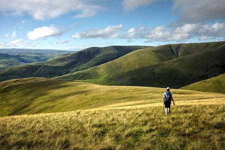
Winder, The Calf & Fell Head from Howgill
Hill Walk + Fell Walk
Nat Park - Yorkshire Dales - Howgill Fells
Region - Howgills
County/Area - Cumbria
Author - Lou Johnson
Length - 9.8 miles / 15.9 km Ascent - 2400 feet / 727 metres
Time - 7 hours 20 minutes Grade - moderate
Maps 

| Ordnance Survey Explorer OL19 | Sheet Map | 1:25k | BUY |
| Anquet OS Explorer OL19 | Digital Map | 1:25k | BUY |
Walk Route Description
Click image to see photo description.
The Howgill Fells offer excellent walking, and this circuit of the western fells is no exception. The walk starts from the small church at Howgill with the first objective an ascent of Winder. The route continues across the flank of Arant Haw then over Calders to The Calf. From here the walk continues over Bush Howe and Fell Head to return to the start. Ideally choose good weather as this route has many glorious views and in poor visibility navigation can be very confusing.
The start is Holy Trinity Church at Howgill (grid ref. SD634950) where limited parking is available. After parking walk east to the road junction and turn right towards Sedbergh. Continue along the route of Roman Road south. After two kilometres the lane forks. Keep left signed to Sedbergh. Continue along the lane past the Height of Winder on your right. After a further 200 metres, turn left up a walled track. You are now heading for Winder. Reaching open country, bear right along a wall and locate a rising track that continues up the fell. This leads to the summit of Winder with an OS trig column and a topograph. Enjoy the view, one of many on this walk.
Leave Winder on a clear grassy path heading northwest. The path descends before climbing steadily to cross the east flank of Arant Haw. After a short descent, the path heads north climbing steadily onto Calders (674 m). From here continue north on an undulating path across Bram Rigg Top to reach The Calf (676 m) the highest point in the Howgill Fells with an OS trig column marking the summit. The view is expansive and includes the Lake District Fells and other areas of high ground in the Yorkshire Dales National Park.
To continue head northwest off the summit along a descending path to cross the eastern flank of White Fell Head. The path veers NNW and climbs briefly over Bush Howe. From here the path bears northwest and descends steeply into a col (Windscarth Wyke). A sharp pull out of the col to Break Head. The path initially heads west and then follows the high ground to reach the summit of Fell Head (623 m). Allow time to take in the final great view of the walk.
The onwards route follows a grassy path steeply down the southwest ridge to Whins End (grid ref SD640976). Turn sharp left to join a descending path which initially heads southeast before swinging south to cross two stream forming part of Ellergill Beck. The route then heads downhill heading southwest roughly parallel to the beck to reach Beck Houses Gate. Pass through the gate and continue downhill past Beck House to Howgill Lane. Turn left and follow the lane south for just under two kilometres back to Howgill church.
Other walks nearby
| Walk 3007 | Fell Head & The Calf from Howgill | moderate | 7.5 miles |
| Walk 3008 | Winder & Arant Haw from Sedbergh | moderate | 7.0 miles |
| Walk 2438 | Cautley Spout & the Calf from Sedbergh | moderate | 10.0 miles |
| Walk 1196 | The Calf | mod/hard | 10.5 miles |
| Walk 3385 | Carlingill Beck, Black Force & Whin's End | mod/hard | 6.5 miles |
| Walk 3006 | Cautley Spout & The Calf | moderate | 5.5 miles |
| Walk 1393 | Yarlside | moderate | 4.0 miles |
| Walk 1387 | Cautley Spout | easy | 2.0 miles |
| Walk 2253 | Uldale Falls & Wandale | moderate | 8.5 miles |
| Walk 1839 | Blease Fell & Hare Shaw from Tebay | easy/mod | 5.7 miles |
Recommended Books & eBooks
Walking the Lake District Fells - Keswick
 Part of the Walking the Lake District Fells series, this guidebook covers a wide range of routes to 30 Lakeland summits that can be climbed from Keswick, Whinlatter, Bassenthwaite, Caldbeck, Mungrisdale and Threlkeld, with highlights including Skiddaw and Blencathra. Includes suggestions for longer ridge routes.
More information
Walking the Lake District Fells - Patterdale
 Part of the Walking the Lake District Fells series, this guidebook covers a wide range of routes to 35 Lakeland summits that can be climbed from Ambleside, Grasmere and Patterdale and the Thirlmere and Ullswater valleys, with highlights including Helvellyn and Fairfield. Suggestions for longer ridge routes are also included.
More information
Messaging & Social Media
Message Walking Britain and follow the latest news.

Mountain Weather
Stay safe on the mountains with detailed weather forecasts - for iOS devices or for Android devices.