Pontcysyllte Aqueduct Circular from Tŷ Mawr
Industrial Heritage Walk + Canal
County/Area - Wrexham & Denbighshire
Author - Lou Johnson
Length - 4.5 miles / 7.3 km Ascent - 450 feet / 136 metres
Time - 2 hours 40 minutes Grade - easy
Maps 

| Ordnance Survey Explorer 256 | Sheet Map | 1:25k | BUY |
| Anquet OS Explorer 256 | Digital Map | 1:25k | BUY |
Walk Route Description
Click image to see photo description.
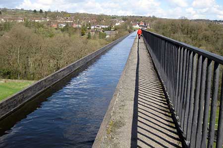
A short but interesting walk that includes Pontcysyllte Aqueduct, which carries the Llangollen Canal across the River Dee. The aqueduct and canal are a World Heritage site being opened in 1805. The aqueduct soars 128 feet above the river and is an impressive structure.
The walk starts from the car park at the nearby Tŷ Mawr Country Park (grid ref. SJ283415). After parking exit the parking area back to Cae Gwilym Lane and turn right. Continue under the railway to a T-junction and turn right along the B5605. Walk through Newbridge, cross the River Dee and continue uphill to Pentre. On your left is the modern viaduct of the A483. And to your right the railway viaduct.
Just after crossing the railway, turn right by the fingerpost to join the towpath of the Llangollen Canal. The treelined canal is a lovely walk and you soon arrive at the black and white lift bridge (grid ref. SJ271413). From here the canal curves right and continues across lofty Pontcysyllte Aqueduct which offers superb views of the Dee Valley and river. After crossing the aqueduct continue to the busy canal basin and former junction at Trevor (grid ref. SJ271422). There are refreshments in season and a series of stone sculptures to view.
To continue retrace your steps back towards the aqueduct to reach the "Hand" sculpture, bear left off the towpath and take the path dropping, steeply in places, to reach the River Dee. Turn left alongside the river and continue to a path junction just after a footbridge. Bear right and continue alongside the River Dee for a kilometre. Nearing the railway viaduct ahead (grid ref. SJ283411), turn left and follow a path back to the car park used at the start of the walk at Tŷ Mawr Country Park.
If you feel unable to cross the aqueduct, then leave the canal by crossing the black and white lift bridge and bear right to a road which has no pavement. Cross the Dee on the medieval Bont Bridge from where you have an excellent view of Pontcysyllte Aqueduct. Once across the river, bear right and follow the road uphill. Nearing the top of the hill, turn right between black and white marker posts, pass under the canal, and then turn sharp left up to the basin.
Other walks nearby
| Walk 2598 | Ruabon Mountain, World's End & Panorama Circular | moderate | 12.5 miles |
| Walk 2388 | Chirk Castle & Ceiriog Valley | easy/mod | 6.0 miles |
| Walk 1067 | Ruabon Mountain & The Limestone Edges of Llangollen | moderate | 11.0 miles |
| Walk 1845 | Castell Dinas Bran from Llangollen | easy/mod | 4.0 miles |
| Walk 3655 | Rhewl, Moel y Gamelin & Moel Morfydd | moderate | 5.4 miles |
| Walk 2905 | The Llangollen Canal from Ellesmere | easy/mod | 8.0 miles |
| Walk 1989 | Llanarmon Dyffryn Ceiriog Circular | moderate | 6.0 miles |
| Walk 3535 | River Dee from Farndon | easy | 4.0 miles |
| Walk 3031 | Cadair Berwyn | moderate | 9.3 miles |
| Walk 1528 | Moel Famau | easy/mod | 10.0 miles |
Recommended Books & eBooks
No suggestions for this area.Messaging & Social Media
Message Walking Britain and follow the latest news.

Mountain Weather
Stay safe on the mountains with detailed weather forecasts - for iOS devices or for Android devices.