The Falls of Glomach from Morvich
Highland Walk
County/Area - Highland - Central Highland
Author - Paul Gasson
Length - 7.5 miles / 12.2 km Ascent - 2300 feet / 697 metres
Time - 6 hours 0 minutes Grade - moderate
Maps 

| Ordnance Survey Explorer 414 | Sheet Map | 1:25k | BUY |
| Anquet OS Explorer 414 | Digital Map | 1:25k | BUY |
| Ordnance Survey Landranger 33 | Sheet Map | 1:50k | BUY |
| Anquet OS Landranger 33 | Digital Map | 1:50k | BUY |
Walk Route Description
Click image to see photo description.
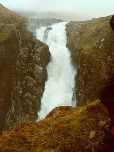
These falls have been called the Hidden Falls, as they are difficult to access, and even more difficult to see, and more than a few people who have set out to see them have failed! They are not the highest falls in Britain, that honour belongs to the Eas a Chual Aluinn (200 metres - 658ft) in Sutherland, but the Falls of Glomach boast the biggest single drop of 113 metres or 375ft and are far and away the most impressive. The name Glomach means gloomy, and these falls can certainly be that in poor weather.
This route starts from the Forestry car park near Morvich (Grid ref NG980223). To reach it take the A87 from Kyle of Lochalsh towards Shiel Bridge, then leave this left, soon after passing through Inverinate, on a road signposted Morvich. After about 1.3km take the single track road going straight ahead when the main road bears right, and ignore the car park sign suggesting you follow the main road. The well surfaced road, with speed humps, ends at a pleasant woodland car park with some picnic tables, and the track to the falls is signposted to the left.
At the T junction bear right, and at the next fork, bear right again, soon crossing the Allt an Leoid Ghainoamhaich on a bridge. A little further on you reach the edge of the forest and emerge into open hill country. Crossing a bridge the track, now just a footpath, climbs steadily up the hillside to reach the highest point on the path, Bealach na Sroine at about 500 metres. If you are as fortunate as we were, deer can be seen on the hills around here. The path at the bealach is fairly level for a while, but be warned, this is serious, wild hill country and the mist can come down quickly, making careful navigation essential.
The path starts to fall, giving good views into the valley far below, and the first glimpse of the top of the falls as the river plunges almost 500ft. into a narrow, twisting gorge. The path then zig zags down steeply to reach the valley floor, and becomes very faint and vague as it traverses off to the left, over boggy ground, to reach the head of the falls. If the mists are down it is all to easy to become lost here, and in any weather the area around the falls is particularly hazardous, with steep, slippery grass and unprotected drops into the abyss. The thunder of the falls fills the air hereabouts, as does the almost permanent haze of spray wafted upwards on the air currents. It is possible to continue a little further left on a hazardous path to gain a slightly better view of the top part of the falls, but eventually the decision has to be made to return by the outward route to the car park.
As with all waterfalls, they are at their most spectacular after heavy rain, but in those conditions they are also at their most hazardous. If you have any doubts about your navigation or general 'hillmanship', it may be better to go on one of the Ranger escorted tours during the summer months.
Other walks nearby
| Walk 3083 | Five Sisters Ridge, North Glen Shiel | very hard | 8.0 miles |
| Walk 2513 | Five day Knoydart exploration | very hard | 91.4 miles |
| Walk 1886 | Carn a' Bhealaich Mhoir | easy/mod | 8.0 miles |
| Walk 1781 | Loch Affric Circular | moderate | 11.0 miles |
| Walk 1789 | Mam Sodhail & Carn Eighe | hard | 14.4 miles |
| Walk 1163 | Fraoch Bheinn | moderate | 5.0 miles |
| Walk 2116 | Beinn Eighe Route Guide | hard | 13.0 miles |
| Walk 2117 | Beinn Eighe - West to East traverse, Torridon | hard | 12.3 miles |
| Walk 2118 | Beinn Eighe traverse including Black Carls, Torridon | hard | 12.5 miles |
| Walk 2119 | Beinn Eighe - The Munros & Sail Mhor, Torridon | hard | 13.0 miles |
Recommended Books & eBooks
Great Mountain Days in Scotland
 Inspirational guidebook to 50 challenging routes for mountaineers, scramblers, hillwalkers and fell runners, many long enough to backpack over 2 days, especially in winter (12 to 25 miles). A mix of classic routes and unsung gems across Scotland from Galloway to the Outer Hebrides in widely differing wild landscapes. With customised OS mapping.
More information
Walking in Torridon
 This guidebook contains 52 day walks in Torridon, a remote and much-loved area of the Scottish Highlands. Based around Shieldaig and Slioch, the routes are split into 3 sections: easy walks, long and high level walks and mountain ascents over 2000ft including 9 Munros, and 5 outline suggestions for major ridge walks.
More information
Messaging & Social Media
Message Walking Britain and follow the latest news.

Mountain Weather
Stay safe on the mountains with detailed weather forecasts - for iOS devices or for Android devices.