Fordon and Dales Circular
Countryside Walk + Dales + Church
Region - Yorkshire Wolds
County/Area - East Yorkshire
Author - Lou Johnson
Length - 5.2 miles / 8.5 km Ascent - 450 feet / 136 metres
Time - 3 hours 0 minutes Grade - easy/mod
Maps 

| Ordnance Survey Explorer 301 | Sheet Map | 1:25k | BUY |
| Anquet OS Explorer 301 | Digital Map | 1:25k | BUY |
Walk Route Description
Click image to see photo description.
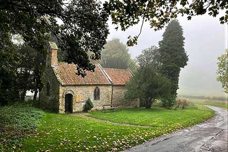
Starting from Fordon, which lies southwest of Hunmanby, this walk explores a landscape typical of the Yorkshire Wolds with the higher ground dissected by deep dry valleys. The route follows paths, quiet lanes and byways and includes the small medieval church of St James in Fordon.
There is limited space to park on the verge opposite the church in Fordon (grid ref. TA050751). After parking and facing the church, turn right to the crossroads. Turn left (signed Willerby Wold) and continue past barns on your right and turn right into a driveway with adjacent fingerpost. Continue past the phone box and letter box. Continue ahead along track and pass through two gates to enter North Dale. The path runs along the foot of the dale with a hedge on your left. Pass through a kissing gate and keep left to the next kissing gate. This leads to a grassy path that stays in the valley floor.
Pass through another kissing gate with adjacent farm gate and continue with a fence on your left. Nearing sheep pens, veer right across a clear track and over a stile (grid ref. TA042769) which leads you into Lang Dale. Continue up the dale. Reaching a side valley on the right, fork left and follow a fence on your left. Shortly after you reach a path junction with the Wolds Way and Centenary Way (grid ref. TA045775). Ignoring the stile, turn right and continue uphill through kissing gates to reach a road.
Turn right along the road keeping ahead when the Wolds Way turns left. Continue for a further 600 metres to where the road bends right. Continue ahead along the access drive to Danebury Manor. When the track bends left, continue ahead past the farm, and follow the track across fields. When the track ends continue ahead to follow a path enclosed with hedges. The path, later becoming a track, descends to a road (grid ref. TA063748). Turn right along the road through East Dale which leads back to the start at Fordon.
Other walks nearby
| Walk 3247 | Stockingdale and Muston from Hunmanby | easy/mod | 7.8 miles |
| Walk 1630 | Filey, Camp Dale & Hunmanby | moderate | 10.5 miles |
| Walk 3428 | Boynton from Rudston Circular | easy | 6.5 miles |
| Walk 3740 | Cowlam & Cottam Circular | easy/mod | 8.0 miles |
| Walk 1631 | Scarborough to Filey | moderate | 10.2 miles |
| Walk 2264 | Bridlington & Flamborough Head | easy/mod | 6.8 miles |
| Walk 1564 | Hayburn Wyke from Scalby | moderate | 10.2 miles |
| Walk 1433 | Martin & Metheringham circular | easy | 6.3 miles |
| Walk 2325 | Troutsdale Circular | moderate | 10.1 miles |
| Walk 1620 | Flamborough Head | easy/mod | 9.7 miles |
Recommended Books & eBooks
No suggestions for this area.Messaging & Social Media
Message Walking Britain and follow the latest news.

Mountain Weather
Stay safe on the mountains with detailed weather forecasts - for iOS devices or for Android devices.