West Bexington & Abbotsbury Circular
Coastal Walk + Downs + Beautiful Village
Region - Jurassic Coast
County/Area - Dorset
Author - Lou Johnson
Length - 7.7 miles / 12.5 km Ascent - 900 feet / 273 metres
Time - 4 hours 50 minutes Grade - moderate
Maps 

| Ordnance Survey Explorer OL15 | Sheet Map | 1:25k | BUY |
| Anquet OS Explorer OL15 | Digital Map | 1:25k | BUY |
Walk Route Description
Click image to see photo description.
Excellent walk from West Bexington that combines the Jurassic Coast and downs. The route follows the South West Coast Path along the northwestern part of Chesil Beach before turning inland to visit St Catherine's Chapel perched on Chapel Hill. The walk then descends into the charming village of Abbotsbury where there is a full range of amenities including pubs and cafés. The route then climbs onto the downs north of the village and follows a ridge offering expansive views before descending back to the start.
The walk starts from Bexington pay and display car park behind the beach (grid ref. SY531865). After parking head southwest along the back of the beach with the sea on your right to follow the South West Coast Path. After an initial section across pebbles the route soon becomes a track. After 3.5 kilometres you reach a car park and café The route continues to follow the South West Coast path which runs along the back of the beach before veering inland. Ahead you can see Chapel Hill which is the next objective.
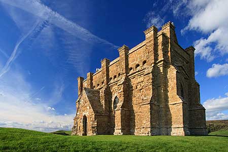
In just under a kilometre from the car park you reach a junction (grid ref. SY568847). Keep right here and follow the path along the base of Chapel Hill for 400 metres before turning left to follow a clear path up to St Catherine's Chapel on the top of the hill with an excellent view along the coast, over Abbotsbury and inland to the downs. Descend northeast off the hill to join Chapel Street which leads to Market Street in Abbotsbury. Turn right and then fork left in from the Old School House into Back Street. If you want to explore the village then return to this point to proceed.
Back Street is lined with attractive thatched cottages. Continue to reach a detached thatched garage on the left. Turn left before the garage to join the onward path, part of the Hardy Way. The clear path soon bends left and shortly after right to climb onto the downs. Nearing the top of the climb, pass through a gate (grid ref. SY574860) and fork left. After a short climb you reach the ridge path where you bear left. Keep ahead to reach a lane. Cross the lane to the path opposite. A short distance on your right are the earthworks of Abbotsbury Castle a former hillfort. The OS trig column marks the highest point of the walk.
Continue along the main path and descend to cross the B3157. Cross the road to the path opposite (signed West Bexington) After a short steeper descent, the path steadily loses height to reach Limekiln Hill. The remains of the kiln are off to your left. Shortly after you reach the B3157 where you fork left down a steep path (still the Hardy Way) which descends to Beach Road in West Bexington. Bear left and return to the start.
Other walks nearby
| Walk 2565 | Littlebredy from Abbotsbury | moderate | 8.5 miles |
| Walk 2827 | Rodden & Langton Herring from Abbotsbury | easy/mod | 9.2 miles |
| Walk 2289 | Abbotsbury Castle and Chesil Beach | easy/mod | 6.0 miles |
| Walk 3523 | Abbotsbury & Portesham Circular | easy | 5.2 miles |
| Walk 2391 | West Bay & Burton Cliff | easy | 4.5 miles |
| Walk 3629 | Eggardon Hill from Loders | moderate | 8.4 miles |
| Walk 2370 | The Fleet from Langton Herring | easy/mod | 7.0 miles |
| Walk 3265 | Eggardon Hill from Powerstock | easy/mod | 6.3 miles |
| Walk 1549 | Golden Cap from Seatown | easy/mod | 4.0 miles |
| Walk 2580 | Golden Cap & Charmouth | easy/mod | 5.0 miles |
Recommended Books & eBooks
South West Coast Path Map Booklet - Minehead to St Ives
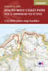 Map of the northern section of the 630 mile (1014km) South West Coast Path National Trail. Covers the trail from Minehead to St Ives along the north Devon and Cornish coastline. This convenient and compact booklet of Ordnance Survey 1:25,000 maps shows the route, providing all of the mapping you need to walk the trail in either direction.
More information
South West Coast Path Map Booklet - St Ives to Plymouth
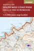 Map of part of the southern section of the 630 mile (1014km) South West Coast Path National Trail. Covers the trail from St Ives to Plymouth along the west Cornwall and Devon coastline. This convenient and compact booklet of Ordnance Survey 1:25,000 maps shows the route, providing all of the mapping you need to walk the trail in either direction.
More information
Messaging & Social Media
Message Walking Britain and follow the latest news.

Mountain Weather
Stay safe on the mountains with detailed weather forecasts - for iOS devices or for Android devices.