Stac Pollaidh Circular
Highland Walk
County/Area - Highland - Northern Highland
Author - Daniel Patrick Quinn
Length - 2.8 miles / 4.6 km Ascent - 1650 feet / 500 metres
Time - 3 hours 0 minutes Grade - easy/mod
Maps 

| Ordnance Survey Explorer 439 | Sheet Map | 1:25k | BUY |
| Anquet OS Explorer 439 | Digital Map | 1:25k | BUY |
| Ordnance Survey Landranger 15 | Sheet Map | 1:50k | BUY |
| Anquet OS Landranger 15 | Digital Map | 1:50k | BUY |
Walk Route Description
Click image to see photo description.
Despite its wild location, and relatively low height, the distinctive-looking Stac Pollaidh is a very popular mountain. This is probably because it can be climbed in under three hours, on a clearly marked path, and amongst what can only be described as some of the most superb scenery in Scotland. From the summit ridge the views are second to none. You can see mountains of the utmost character, such as Cul Mor and Suilven, which rise suddenly and steeply from the watery Inverpolly Nature Reserve. The area is full of tiny lochs and the views west to the ocean are just beautiful.
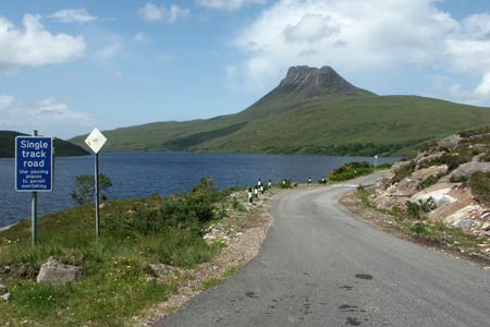
Head northwards on the A835 from Ullapool. After ten miles or so, there is a left turning, signposted to Achiltibuie and the Summer Isles. The narrow road meanders along the side of Loch Lurgainn, beneath towering Cul Beag and Stac Pollaidh. The small Inverpolly Nature Reserve car park is on the left side of the road. It is ideally situated at the foot of Stac Pollaidh. Cross the road and go through the gate. Follow the steep, well-built path as it leads you up the mountain. The short ascent is quite strenuous, but there are plenty of places to have a rest on the way up. Half way up is a second gate. Here the path divides into two. It doesn't matter which path you take since they both lead round the back of the mountain, effectively encircling it. This means you can return by a different route.
Once the path has led you round to the northern face of Stac Pollaidh, the summit ridge is clearly visible. As height is quickly gained, the views in every direction are stunning. As you negotiate the final, rocky ascent to the summit ridge, the view to the north is particularly spectacular. It is a great vantage point to admire the beautiful and unique peaks of Cul Mor, Suilven, Canisp, and Quinag. On a clear day, you should even be able to see the quartzite ridge of Foinaven in the far distance.
The path leads up to the lowest point on the summit ridge, which is roughly halfway along. Wonderful sandstone turrets and gullies surround you. The view south across Loch Lurgainn to Ben More Coigach is superb. A well-worn path runs in and out of these turrets along the summit ridge from one end to the other. There are cairns on several of the sandstone tops. It is important to take care, for there are many steep drops.
Getting to the true summit of Stac Pollaidh is quite difficult, and should not be attempted if you have any doubts whatsoever. Indeed, the view is only marginally better from the true top than it is from any number of the other cairned spots on the summit ridge. If you do wish to reach the true top, follow the path west along the ridge. There are a few places where you will need to hold onto the rock as you scramble across tricky sections. The most westerly cairn is the true top, but to reach it you will have to negotiate a very exposed scramble. It involves climbing a rather badly eroded five-metre rock step, with huge drops on both sides. There are hand holds but if in doubt, don't risk it, especially if the rock is wet.
To descend, return to the lowest point on the summit ridge half way along. Retrace your steps down the northern face of Stac Pollaidh and return to the car park by either of the two paths that encircle the mountain.
Other walks nearby
| Walk 2274 | Cul Mor from Knockan Crag | mod/hard | 8.5 miles |
| Walk 1316 | Falls of Kirkaig | easy | 5.8 miles |
| Walk 1769 | Suilven (North-western approach) | hard | 12.0 miles |
| Walk 1312 | Achmelvich Bay and Alltanabradhan | easy | 3.0 miles |
| Walk 1319 | The Bone Caves of Inchnadamph | easy | 3.0 miles |
| Walk 1018 | Beinn Ghobhlach | moderate | 6.0 miles |
| Walk 3272 | Conival & Ben More Assynt from Inchnadamph | hard | 11.0 miles |
| Walk 1317 | Sail Gharbh (Quinag) | moderate | 5.4 miles |
| Walk 1117 | Glas Bheinn & Eas a' Chual Aluinn (waterfall) | mod/hard | 8.5 miles |
| Walk 1266 | The Old Man of Stoer and the Point of Stoer | easy | 4.5 miles |
Recommended Books & eBooks
Walking in Torridon
 This guidebook contains 52 day walks in Torridon, a remote and much-loved area of the Scottish Highlands. Based around Shieldaig and Slioch, the routes are split into 3 sections: easy walks, long and high level walks and mountain ascents over 2000ft including 9 Munros, and 5 outline suggestions for major ridge walks.
More information
Walking the Munros Vol 2 - Northern Highlands and the Cairngorms
 Guidebook to walking the northern Munros, covering the northern Highlands, the Cairngorms and the Isle of Skye. 70 routes are described, including those up Ben Macdui, Braeriach and Cairn Gorm. Routes range from 7 to 46km, requiring a fair level of fitness. The second of two guidebooks to walking Scotland's Munros: peaks higher than 3000ft.
More information
Messaging & Social Media
Message Walking Britain and follow the latest news.

Mountain Weather
Stay safe on the mountains with detailed weather forecasts - for iOS devices or for Android devices.