Hartsop Dodd, Stony Cove Pike, High St. & The Knott
Lake District Walk
Nat Park - Lake District - Lake District Far Eastern Fells
Wainwrights - Hartsop Dodd, High Raise, High Street, Kidsty Pike, The Knott, Rampsgill Head, Thornthwaite Crag,
County/Area - Cumbria
Author - Bill Milne
Length - 10.0 miles / 16.3 km Ascent - 3500 feet / 1061 metres
Time - 8 hours 30 minutes Grade - mod/hard
Maps 

| Ordnance Survey Explorer OL5 | Sheet Map | 1:25k | BUY |
| Anquet OS Explorer OL5 | Digital Map | 1:25k | BUY |
| Ordnance Survey Landranger 90 | Sheet Map | 1:50k | BUY |
| Anquet OS Landranger 90 | Digital Map | 1:50k | BUY |
Walk Route Description
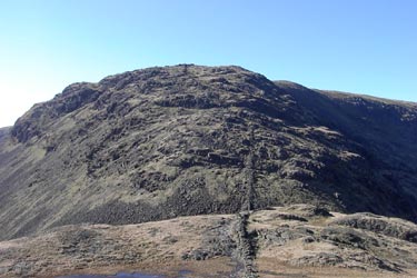
Click image to visit gallery of 3 images.
This circular Lake District walk takes in the summits of Hartsop Dodd, Stony Cove Pike, High Street and The Knott. The route includes considerable ascent but offers some great Lakeland views as a rewards for your efforts. To start the walk, leave the car in the car park near the sheep fold in Hartsop (off the Kirkstone Pass road), set off straight up Hartsop Dodd, keeping the dry stone wall on the right. Having gained height quickly, the vista is just incredible and it is easy to pick out Helvellyn, the two 'Edges' - Striding and Swirral - Catstye Cam, the Langdales and Skiddaw ranges.
Continuing along the top, gradually climb, keeping the wall to your left, along to Stony Cove Pike, at which point turn due East (left) and descend to Threshwaite Mouth, but not before savouring the fabulous view over The Tongue to Windermere and across to the west, our old friends, Pavey Ark and Harrison Stickle.
From the col of Threshwaite Mouth there follows a steep climb, described by a septegenarian we greeted as a 'naughty little ascent' of scree strewn path to the beacon atop Thornthwaite Crag. The footpath along High Street is self evident, but be warned, the trig point is only attained by veering off the path across the grassy fell to the right.
Once achieved, it is merely a matter of following the wall down to Short Stile where the path is rejoined before swinging round to Kidsty Pike on the far side of the Riggindale valley. It is worth pausing at Short Stile to look across the valley towards Haweswater and try to catch the eagles riding the thermals … unfortunately none were around, but that would have just been too perfect a day!
Bearing almost due north at Kidsty Pike leads up to High Raise from whence steps are retraced via Rampsgill Head to the footpath and the ever-present dry stone wall that you left for Kidtsy Pike. Prior to descending towards Rest Dodd, turn left to The Knott and the splendid cairn marking the summit. At this point Rest Dodd and The Nab are within striking distance and I would suggest another 2 hours would see these 'bagged' if you wish.
As it is, winding down the valley to Hayeswater and following the track back to the car park at the foot of Hartsop Dodd completes a taxing but enjoyable day.
Other walks nearby
| Walk 1110 | Angletarn Pikes | moderate | 7.0 miles |
| Walk 2060 | The Angletarn Pikes and Brock Crags from Hartsop | moderate | 8.0 miles |
| Walk 3388 | Hayeswater and Angle Tarn from Hartsop | mod/hard | 11.5 miles |
| Walk 2386 | Red Screes via Dove Crag | mod/hard | 8.6 miles |
| Walk 1230 | Birks & Arnison Crag | moderate | 5.5 miles |
| Walk 1520 | Helvellyn & Fairfield Horseshoe from Patterdale | very hard | 13.0 miles |
| Walk 2047 | Place Fell | moderate | 7.5 miles |
| Walk 2425 | Boredale Circular from Patterdale | mod/hard | 11.5 miles |
| Walk 3670 | Angle Tarn and Hayeswater | moderate | 8.3 miles |
| Walk 1156 | Helvellyn via Striding Edge | hard | 9.5 miles |
Recommended Books & eBooks
Hadrian's Wall Path
 Hadrians Wall Path guidebook to walk the 84 mile National Trail. Described in both directions, the main description is west to east between Bowness-on-Solway and Wallsend, Newcastle, with extensions to Maryport and South Shields. With extensive historical information related to this World Heritage site and separate 1:25,000 OS map booklet included.
More information
Walking the Lake District Fells - Patterdale
 Part of the Walking the Lake District Fells series, this guidebook covers a wide range of routes to 35 Lakeland summits that can be climbed from Ambleside, Grasmere and Patterdale and the Thirlmere and Ullswater valleys, with highlights including Helvellyn and Fairfield. Suggestions for longer ridge routes are also included.
More information
Messaging & Social Media
Message Walking Britain and follow the latest news.

Mountain Weather
Stay safe on the mountains with detailed weather forecasts - for iOS devices or for Android devices.