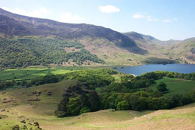
Grasmoor via Crag Hill from Buttermere village
Lake District Walk
Nat Park - Lake District - Lake District North Western Fells
Wainwrights - Eel Crag, Grasmoor, Wandope, Whiteless Pike
County/Area - Cumbria
Author - Peter Aris
Length - 8.0 miles / 13 km Ascent - 3200 feet / 970 metres
Time - 7 hours 10 minutes Grade - mod/hard
Maps 

| Ordnance Survey Explorer OL5 | Sheet Map | 1:25k | BUY |
| Anquet OS Explorer OL5 | Digital Map | 1:25k | BUY |
| Ordnance Survey Landranger 90 | Sheet Map | 1:50k | BUY |
| Anquet OS Landranger 90 | Digital Map | 1:50k | BUY |
Walk Route Description
Click image to visit gallery of 9 images.
This Lake District walk description is based on the series of photographs taken by me on 16th May 2004 during a walk from Buttermere. The weather was perfect with excellent long distance visibility with the distant early morning view of Great Gable with a cloak of mist being particularly noteworthy.
The start is the car park in Buttermere (Grid ref. NY173169). From the car park walk to the main road in the centre of the village and turn left towards Lorton. Cross Mill Beck and take the path on your right that follows this stream. Continue uphill to reach the indistinct col between Low Bank and Whiteless Pike (Grid ref. NY 179177). The climb continues up Whiteless Breast to reach the summit of Whiteless Pike.
The path loses some height as you continue along a well defined ridge with a steep drop to your right before climbing to the summit of Wandhope. Continuing you skirt Addacomb Hole on your right to reach the summit of Crag Hill from where there are extensive views in all directions.
Retracing your steps for a short way, ignore the path to Wandhope, instead descending gently to the col between Crag Hill and Grasmoor. Continue uphill to the summit of the latter peak. The domed summit area is not well suited for those wishing to enjoy the view and if you want to look down towards Crummock Water then continue a short way west past the summit cairn and shelter.
With the last summit of the day in the bag locate the steep path that descends over Lad Hows to Cinderdale Common. This is not the easiest descent if, like me, you're unfit and overweight! The views are fantastic though and well worth the pain - much better than via Coledale Hause and Gasgale Gill.
Reaching the road at Cinderdale Common turn left and walk back to Buttermere to enjoy a well earned pint at the Fish Hotel.
Other walks nearby
| Walk 2642 | Buttermere Horseshoe | very hard | 14.0 miles |
| Walk 2539 | Grasmoor and Rannerdale Knotts | moderate | 8.0 miles |
| Walk 1732 | Coledale and Newlands circular from near Buttermere | hard | 9.0 miles |
| Walk 1011 | Knott Rigg and Ard Crags | easy/mod | 3.5 miles |
| Walk 1231 | Grasmoor via Whiteless Pike | moderate | 7.0 miles |
| Walk 2020 | Rannerdale Knotts and Crummock Water from Cinderdale Common | easy/mod | 2.5 miles |
| Walk 1153 | The High Stile Ridge | hard | 10.0 miles |
| Walk 1289 | Fleetwith Pike & Haystacks | moderate | 5.5 miles |
| Walk 2021 | Whiteside, Hopegill Head & Grisedale Pike | moderate | 7.5 miles |
| Walk 3676 | Hen Comb from Loweswater | moderate | 5.4 miles |
Recommended Books & eBooks
Walking the Lake District Fells - Langdale
 Part of the Walking the Lake District Fells series, this guidebook covers a wide range of routes to 25 Lakeland summits that can be climbed from the Great Langdale valley, Ambleside and Grasmere, with highlights including Scafell Pike, Bowfell, the Langdale Pikes and Helm Crag (the Lion and the Lamb). Includes suggestions for longer ridge routes.
More information
Walking the Lake District Fells - Patterdale
 Part of the Walking the Lake District Fells series, this guidebook covers a wide range of routes to 35 Lakeland summits that can be climbed from Ambleside, Grasmere and Patterdale and the Thirlmere and Ullswater valleys, with highlights including Helvellyn and Fairfield. Suggestions for longer ridge routes are also included.
More information
Messaging & Social Media
Message Walking Britain and follow the latest news.

Mountain Weather
Stay safe on the mountains with detailed weather forecasts - for iOS devices or for Android devices.