The Black Mountain, Brecon Beacons
Brecon Beacons/Bannau Brycheiniog Walk
Nat Park - Brecon Beacons - Brecon Beacons West
County/Area - Carmarthenshire
Author - Hugh Maguire
Length - 8.0 miles / 13 km Ascent - 2400 feet / 727 metres
Time - 6 hours 20 minutes Grade - moderate
Maps 

| Ordnance Survey Explorer OL12 | Sheet Map | 1:25k | BUY |
| Anquet OS Explorer OL12 | Digital Map | 1:25k | BUY |
| Ordnance Survey Landranger 160 | Sheet Map | 1:50k | BUY |
| Anquet OS Landranger 160 | Digital Map | 1:50k | BUY |
Walk Route Description
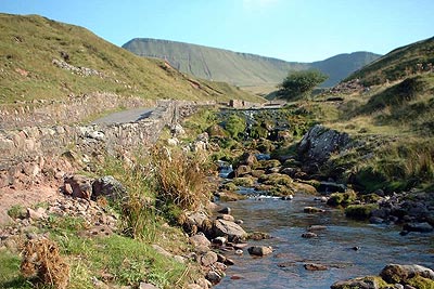
Click image to visit gallery of 6 images.
The Black Mountain forms the western high ground of the Brecon Beacons National Park and should not be confused with the Black Mountains in the east of the same Park. Rising to 802 metres (2631 ft) Fan Brycheiniog the summit of the Black Mountain is the third highest top in South Wales.
To reach the start of the walk leave the A40(T) at Trecastle and head south west to Llanddeusant. Then follow the signs to Llyn y Fan Fach. The road turns into a track which almost disappears as you head into remoteness. When you can go no further (the track is blocked) park on the right of the track in an angle made by the track and the river (Grid ref. SN 798238).
Now walk south along the track through the valley past the trout farm and water works. As you walk spectacular views of the cliffs of Bannau Sir Gaer appear ahead. After a couple of miles a dirt path leaves the main track to the right and you can follow this as it makes it's way around the western side of Llyn Y Fan Fach and up to the top of the cliffs. However you might prefer to follow the path to the lake itself before following the path up the cliffs.
When you get to the western side of the lake and almost to the top of the cliffs it is worth stoping to enjoy the view. Below is the lake, Lyn y Fan Fach, while stretching off into the distance are the cliffs of Bannau Sir Gaer with Fan Foel stretching out to the north.
It is now a case of following the ups and downs and in and outs of the cliffs until you reach the trig point on Fan Brycheiniog, the top of the Black Mountain. Below the cliff is another small lake Llyn Y Fan Fawr. This is another good spot to stop and admire the excellent views, especially towards the Brecon Beacons in the east.
At this point there are several options for you to choose from for the return. You may prefer to retrace your footsteps and return to your car following the route you walked out on. Or you may choose to carry on a bit further along the cliffs to the "Staircase" which descends the cliffs to the southern shore of the lake. You can then follow the base of the cliffs (this can be boggy) back to Llyn Y Fan Fach. You may prefer, having rounded Fan Foel, to "cut the corner" and meet the path you walked in on halfway down.
My favourite (and the route shown on the map), however, is to follow the clifftop back to the low point between Fan Foel and Bannau Sir Gaer. There is a very narrow path here, almost a sheep track, which twists and turns it's way down the cliffs. At the bottom strike out north west to meet the track you walked in on somewhere near it's junction with the Afon Sychlwch. There is a pool here and on a hot day it is great to get the boots off and stick ones feet in the cool water. Then it's down the track and back to the car.
Other walks nearby
| Walk 2641 | Fan Fawr & Fan Frynych, Fforest Fawr | moderate | 6.5 miles |
| Walk 3616 | Fan Fawr from Storey Arms | moderate | 6.0 miles |
| Walk 2349 | Pen Y Fan & Corn Du from near Storey Arms | moderate | 4.6 miles |
| Walk 2400 | Pen y Fan from Cwmgwdi near Brecon | moderate | 5.0 miles |
| Walk 1903 | Pen y Fan & Corn Du from Cwmgwdi | moderate | 7.5 miles |
| Walk 2074 | Highest Peaks of the Brecon Beacons | mod/hard | 11.0 miles |
| Walk 3210 | Pen-y-Crug hill fort from Brecon | easy | 3.0 miles |
| Walk 3564 | Groesfford and M & B Canal from Brecon | easy/mod | 6.2 miles |
| Walk 3236 | Pen-y-crug, Sarnau and Battle from Brecon | moderate | 10.0 miles |
| Walk 2643 | Fan Frynych & Fan Llia, Fforest Fawr | moderate | 8.0 miles |
Recommended Books & eBooks
Walking in Carmarthenshire
 Guidebook to 30 walking routes (2 to 10 miles) in Carmarthenshire, south Wales, including sections of Carmarthenshire Coast Path. Walks for all abilities, including coastal, river, forest and hill walks in Cambrian Mountains, Tywi Valley, Y Mynydd Du (Black Mountains) and Brecon Beacons. Easy access from Bristol, Cardiff and Swansea.
More information
Walking on the Brecon Beacons
 45 circular day walks are described in this guidebook to the Brecon Beacons National Park. From west to east, Mynydd Du, Fforest Fawr, the Brecon Beacons and the Black Mountains these mountain and valley routes offer many options, highlighting the natural features. The walks described explore dramatic waterfalls, wooded gorges and upland valleys.
More information
Messaging & Social Media
Message Walking Britain and follow the latest news.

Mountain Weather
Stay safe on the mountains with detailed weather forecasts - for iOS devices or for Android devices.