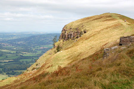
Ysgyryd Fawr (The Skirrid) near Abergavenny
Brecon Beacons/Bannau Brycheiniog Walk
Nat Park - Brecon Beacons - Brecon Beacons East
County/Area - Monmouthshire
Author - Lou Johnson
Length - 3.5 miles / 5.7 km Ascent - 1050 feet / 318 metres
Time - 2 hours 50 minutes Grade - easy/mod
Maps 

| Ordnance Survey Explorer OL13 | Sheet Map | 1:25k | BUY |
| Anquet OS Explorer OL13 | Digital Map | 1:25k | BUY |
| Ordnance Survey Landranger 161 | Sheet Map | 1:50k | BUY |
| Anquet OS Landranger 161 | Digital Map | 1:50k | BUY |
Walk Route Description
Click image to see photo description.
The Skirrid (Ysgyryd Fawr) lies a mile or so to the east of Abergavenny. This solitary hill rises steeply from the surrounding countryside and offers some outstanding views over the Brecon Beacons National Park. Approaching the hill it looks far bigger than its height, just under 1600 feet above sea level, would suggest. The route obviously includes a steady ascent and a rather steeper descent after you have crossed the summit.
The start is a small car park on the B4521 at grid ref. SO328163. After parking take the Beacons Way footpath signed to Ysgyryd Fawr. The path immediately starts climbing through Caer Wood. Exiting the wood you reach a path junction. Continue ahead staying on the Beacons Way. The path then ascends the south ridge of the hill to reach the summit on a clear wide path.
You could return the way you came but a more enjoyable descent is to continue north from the summit heading just west of north. The path drops quite steeply. At the bottom of the hill take the path on your left. This leads across the western flank of the hill through woodland. You will return to the point where you left Caer Wood on the outward leg of the route. Turn right here and descend through wood and back to the start.
Other walks nearby
| Walk 1271 | Sugar Loaf circular | moderate | 6.0 miles |
| Walk 1664 | The Sugar Loaf | easy | 3.5 miles |
| Walk 3435 | Keeper's Pond & Blorenge | easy/mod | 7.5 miles |
| Walk 1415 | Iron Mountain Trail - 'Llwybr Mynydd Haearn' - Part 1 | easy/mod | 7.5 miles |
| Walk 1512 | Iron Mountain Trail - 'Llwybr Mynydd Haearn' - Part 2 | easy/mod | 5.0 miles |
| Walk 1874 | The River Usk from Bettws Newydd | easy/mod | 6.5 miles |
| Walk 3717 | Table Mountain from Crickhowell | easy/mod | 5.0 miles |
| Walk 3134 | The Llangatwg Escarpment from near Crickhowell | moderate | 6.5 miles |
| Walk 1237 | Cwmyoy & Hatterrall Hill from Llanthony Priory | moderate | 10.0 miles |
| Walk 3203 | Vale of Ewyas from Llanthony Abbey | moderate | 10.7 miles |
Recommended Books & eBooks
Walking in Carmarthenshire
 Guidebook to 30 walking routes (2 to 10 miles) in Carmarthenshire, south Wales, including sections of Carmarthenshire Coast Path. Walks for all abilities, including coastal, river, forest and hill walks in Cambrian Mountains, Tywi Valley, Y Mynydd Du (Black Mountains) and Brecon Beacons. Easy access from Bristol, Cardiff and Swansea.
More information
Walking on the Brecon Beacons
 45 circular day walks are described in this guidebook to the Brecon Beacons National Park. From west to east, Mynydd Du, Fforest Fawr, the Brecon Beacons and the Black Mountains these mountain and valley routes offer many options, highlighting the natural features. The walks described explore dramatic waterfalls, wooded gorges and upland valleys.
More information
Messaging & Social Media
Message Walking Britain and follow the latest news.

Mountain Weather
Stay safe on the mountains with detailed weather forecasts - for iOS devices or for Android devices.