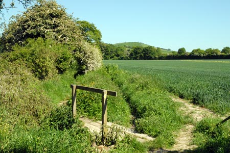
Old Winchester Hill from Exton
Hampshire Walk
County/Area - Hampshire
Author - Lou Johnson
Length - 5.5 miles / 8.9 km Ascent - 450 feet / 136 metres
Time - 3 hours 10 minutes Grade - easy/mod
Maps 

| Ordnance Survey Explorer OL3 | Sheet Map | 1:25k | BUY |
| Anquet OS Explorer OL3 | Digital Map | 1:25k | BUY |
| Ordnance Survey Explorer OL32 | Sheet Map | 1:25k | BUY |
| Anquet OS Explorer OL32 | Digital Map | 1:25k | BUY |
| Ordnance Survey Landranger 185 | Sheet Map | 1:50k | BUY |
| Anquet OS Landranger 185 | Digital Map | 1:50k | BUY |
Walk Route Description
Click image to visit gallery of 2 images.
The attractive Meon Valley is one of the scenic highlights of this part of Hampshire. The village of Exton lies just off the A32 main road. The start is a small parking area (grid ref. SU617212) which is reached by turning off the A32 and taking the northernmost of the two lanes off the main road into the village. Immediately after turning off the A32 the small parking area is evident on your left. Note that in fine weather and busy periods that this may get full quite quickly.
After parking, take care and cross over the A32 to follow the South Downs Way towards Old Winchester Hill. The first section of path does not encourage you to step out as after crossing a small footbridge there are some tree roots and other minor obstructions to negotiate. Despite this relatively slow progress you soon reach the old railway. Turn left along the old trackbed. This railway was called the Watercress Line and a section to the north of here is now preserved with steam trains in operation.
You can now step it out! Crossing the lane to Peake farm (grid ref. SU628218) is about the half way point to where we will leave the old railway. This is good walking and you can keep a good pace along this section. Reaching a deep cutting with a road over bridge (grid ref. SU633228), go under the bridge and take the path that climbs up to the road on your left. Reaching the road turn left over the bridge and walk for about 300 yards. Look out for the Monarch's Way footpath sign on your right.
Turn right onto this track, which leads you towards Peake's Farm. Nearing the farm the footpath is diverted away from the main buildings. Just follow the signed route which lead you back onto a track which ends after passing a small wood (grid ref. SU633212) Continue straight ahead here beginning to climb towards the summit of Old Winchester Hill. Bear left when you join the South Downs Way. The way ahead steepens but quite soon you are on the summit of the hill and able to enjoy wide ranging views of the Meon Valley.
To continue, descend the way you came. However do not retrace your steps towards Peake Farm, instead walking straight ahead to descend to the old railway. Cross the railway and all that remains is the short awkward section of path back to the main road and the start.
Other walks nearby
| Walk 1034 | Beacon and Old Winchester Hills on the South Downs | moderate | 10.5 miles |
| Walk 2533 | East Meon to Old Winchester Hill | moderate | 12.0 miles |
| Walk 2394 | East Meon & Wether Down | easy/mod | 8.0 miles |
| Walk 2373 | Hambledon Circular | easy/mod | 6.1 miles |
| Walk 3324 | Cheriton Mill & Tichborne from Cheriton | easy | 5.7 miles |
| Walk 3260 | Butser Hill Circular | easy/mod | 6.9 miles |
| Walk 2383 | Upham & Owslebury Circular | easy/mod | 6.5 miles |
| Walk 2422 | Butser Hill and Wether Down from Buriton | moderate | 12.5 miles |
| Walk 1964 | Abbotstone from Old Alresford | easy | 5.1 miles |
| Walk 1976 | Noar Hill from Selborne | easy/mod | 5.0 miles |
Recommended Books & eBooks
The South Downs Way
 Guidebook to walking the South Downs Way National Trail, a 100 mile (160km) route between Winchester and Eastbourne through the South Downs National Park, described in both directions over 12 stages. Easy walking on ancient and historical tracks, taking in wooded areas, delightful river valleys and pretty villages. With 1:25K OS map booklet.
More information
Walking Hampshire's Test Way
 Guidebook to walking the 71km (44 mile) Test Way in Hampshire from high on the chalk downs of Inkpen Beacon to the Eling Tide Mill near Southampton Water. Following the beautiful, crystal clear River Test, it passes picturesque villages and fascinating historic sites. Also includes 15 day walks to explore this lovely part of pastoral England.
More information
Messaging & Social Media
Message Walking Britain and follow the latest news.

Mountain Weather
Stay safe on the mountains with detailed weather forecasts - for iOS devices or for Android devices.