Walk 2718 - printer friendly version
The Scafells from Wasdale Head Walk
Author - Peter Smyly
Length - 9.0 miles / 14.6 km
Ascent - 4000 feet / 1212 metres
Grade - mod/hard
Start - OS grid reference NY186085
Lat 54.465322 + Long -3.2573609
Postcode CA20 1EX (approx. location only)
Several walking routes lead to the top of Scafell and Scafell Pike, the two highest peaks in England, and the shortest distance "as the crow flies" is this one.
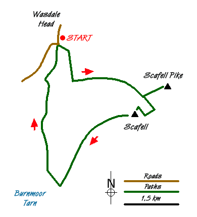
This wonderful Lake District walk starts from the car park at Wasdale Head and cross the bridge over Lingmell Beck .The twin objectives of the two Scafells dominate the view ahead, either side of the col of Mickledore and, in good visibility at least, route-finding should present no difficulties. A clear track leads, steeply in places, up past Lingmell Gill, crossing it at one point, on the way towards Brown Tongue and Hollow Stones below the cliffs at the front of Scafell Pike, Pikes Crag. The summit is out of sight from this angle, a few hundred yards beyond Pikes Crag. While one option is to skirt round to the left between Scafell Pike and Lingmell, for this walk, the next objective is to climb up Mickledore. The cliffs of Scafell dominate the view to the right on approaching Mickledore, This is a stiff climb which gets even steeper, the higher up you get to the point where hands as well as feet may be needed in the latter stages until Mickledore is reached. From Mickledore, a path winds its way up to the summit of Scafell Pike. The very top features a raised area, accessible by a short flight of steps and it is likely that, especially in good weather, other walkers will already be there. After drinking in the all-round views, reverse the route back down to Mickledore. Tempting though the more direct approach via Lord's Rake is to the right, this idea should be avoided since there is a risk of rock fall, therefore this is a "no go" area. From Mickledore, you need to lose a few hundred feet in height to the left that then has to be regained as you descend steeply to reach a point where you have gone beyond the insurmountable rock face of Broad Stand.
Conveniently, a gully to the left of Broad Stand provides access by means of an easy scramble up a gully alongside a stream which leads up to diminutive Foxes Tarn. A giant boulder presides over the tarn which must be one of the smallest in the Lake District to have a name. Another steep uphill walk to the north-west on loose stones leads to the Scafell summit plateau from where it is an easy walk to the top itself. Now descend to the south-west with Burnmoor Tarn seen below to the left of Illgill Head. The area around the edges of the tarn is liable to be boggy underfoot but in any case, before you get there, a path leads away to the right at the bottom of the slopes off Scafell and takes you back to the walk's start point at Wasdale Head.
Messaging & Social Media
Message Walking Britain and follow the latest news.

Mountain Weather
Stay safe on the mountains with detailed weather forecasts - for iOS devices or for Android devices.