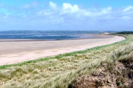
Whiteford Sands from Llanmadoc
Gower Peninsula Walk
Region - Gower Peninsula
County/Area - Swansea
Author - Lou Johnson
Length - 5.1 miles / 8.3 km Ascent - 250 feet / 76 metres
Time - 2 hours 50 minutes Grade - easy
Maps 

| Ordnance Survey Explorer 164 | Sheet Map | 1:25k | BUY |
| Anquet OS Explorer 164 | Digital Map | 1:25k | BUY |
Walk Route Description
Click image to see photo description.
The Gower Peninsula has much scenic interest both along the coast and inland. This walk explores the sand spit jutting out into the Loughor Estuary and provides some excellent walking with views inland and along the coast. The start is the carpark on the north side of Llanmadoc Village (grid ref. SS439935).
Exit the car park and turn right and follow the lane to the hamlet of Cwm Ivy. Continue ahead through a gate and follow the tarmac lane downhill through trees to a junction (grid ref. SS437939). Bear right here and join the Wales Coast Path. You soon pass a cottage on your left and pass through woodland before emerging into open country with mudflats and salt marsh to your right beyond which lies the River Loughor. The well-defined track heads north. After a mile (grid ref. SS447952) you leave the track just after it bends to the left and continue on a narrower path still with the estuary on your right.
Reaching Whiteford Point (grid ref. SS447966) the Wales Coast Path turns south along the seaward side of the spit with sand dunes to your left and the sea to your right. Depending on tides you do have the option of walking along the broad expanse of Whiteford Sands. After just under two miles you reach the foot of Cwm Ivy Tor with its Limestone Crags and a path junction (grid ref. SS433940). Turn left here and join a clear track heading east to Cwm Ivy. You soon re-join your outward route and pass the cottages at Cwm Ivy. All that remains is to follow the lane gently uphill back to the start.
Other walks nearby
| Walk 2191 | Cheriton & Weobley Castle from Landimore | easy/mod | 5.2 miles |
| Walk 2424 | Harding's Down & Rhossili Down | moderate | 9.0 miles |
| Walk 3258 | The Beacon from Rossili | easy | 4.0 miles |
| Walk 1967 | Worms Head from Rhossili | easy | 3.3 miles |
| Walk 1960 | Worms Head from Pilton Green | easy/mod | 7.5 miles |
| Walk 2144 | Port-Eynon from Pilton Green | easy/mod | 6.4 miles |
| Walk 2277 | Oxwich Point Circular from Oxwich | easy/mod | 3.5 miles |
| Walk 2287 | Cefn Bryn & Penrice | easy/mod | 7.7 miles |
| Walk 3761 | Cefn Bryn & Three Cliffs Bay from Penmaen | moderate | 9.0 miles |
| Walk 2358 | Parc le Breos near Parkmill | easy | 3.6 miles |
Recommended Books & eBooks
No suggestions for this area.Messaging & Social Media
Message Walking Britain and follow the latest news.

Mountain Weather
Stay safe on the mountains with detailed weather forecasts - for iOS devices or for Android devices.