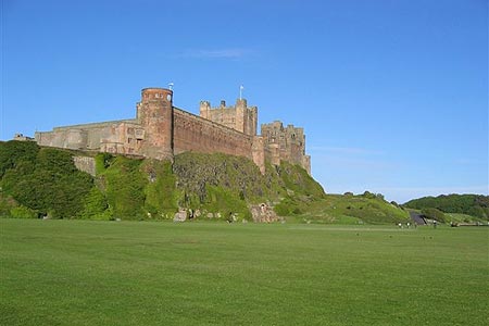
Budle Bay from Bamburgh
Northumberland County Walk
County/Area - Northumberland County
Author - Mike Bexley
Length - 4.0 miles / 6.5 km Ascent - 350 feet / 106 metres
Time - 2 hours 20 minutes Grade - easy
Maps 

| Ordnance Survey Explorer 340 | Sheet Map | 1:25k | BUY |
| Anquet OS Explorer 340 | Digital Map | 1:25k | BUY |
| Ordnance Survey Landranger 75 | Sheet Map | 1:50k | BUY |
| Anquet OS Landranger 75 | Digital Map | 1:50k | BUY |
Walk Route Description
Click image to visit gallery of 6 images.
This is a very easy short walk with superb coastal views. The walk requires no special clothing. Just dress comfortable with an eye on the weather. Although I have quoted map grid references, a map is not required just follow the outlined route that accompanies this description. The walk starts with a road walk but this is soon forgotten when the views hit you in the face.
Leave Bamburgh village (grid ref NU182350) via the B1342 road passing the church and keeping to the right hand grass verge. Pass a minor road on the left then just after the road turns right go through the right gate indicated by a footpath sign (Grid ref. NU164350 ). This path, indicated by blue posts, crosses the golf course so keep a look out for the golfers and their flying objects. Exit the golf course via a swing gate.
The path now descends to some cottages, this section provides your first magnificent view of Budle Bay. The public footpath proceeds between Newtown Cottages. However to avoid the obstacles placed in its way it is easer to walk to the left around them to a large metal gate at the bottom of the field. Turn right then right again following a bridle way sign leading to gate onto the golf course (grid ref NU 162356). Turn left and steeply descend to the path junction by the remains of a war time pill box. Turn right up hill, where if you are lucky, there is vacant bench to sit and take in the views across the bay to Holy Island.
The clear path continues along the edge of the golf course prior to crossing over a fairway to the club house. Going through the gate leads to a narrow lane named The Wynding. This lane leads back to Bamburgh village. However I prefer to take the left hand bridleway just after the second car park and right corner (Grid ref. NU179353). This track leads you past Coast Guard cottages and on to the large village green at the foot of the castle with the village on the far side.
Other walks nearby
| Walk 3522 | Bamburgh Castle circular | easy/mod | 7.5 miles |
| Walk 3242 | Holy Island - Lindisfarne Castle & Emmanuel Head | easy | 4.4 miles |
| Walk 3344 | Holy Island & Lindisfarne Castle Circular | easy | 4.3 miles |
| Walk 1199 | Dunstanburgh Castle | easy | 4.5 miles |
| Walk 3335 | Howick & Cullernose Point | easy | 4.5 miles |
| Walk 2397 | Beadnell to Craster | easy/mod | 7.9 miles |
| Walk 2282 | Bewick Moor | moderate | 9.1 miles |
| Walk 2677 | Circuit of Doddington Moor | easy | 3.8 miles |
| Walk 1805 | An introduction to the Breamish Valley | easy | 2.0 miles |
| Walk 1764 | The Cheviot from Langleeford | mod/hard | 8.2 miles |
Recommended Books & eBooks
Hadrian's Wall Path
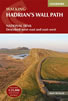 Hadrians Wall Path guidebook to walk the 84 mile National Trail. Described in both directions, the main description is west to east between Bowness-on-Solway and Wallsend, Newcastle, with extensions to Maryport and South Shields. With extensive historical information related to this World Heritage site and separate 1:25,000 OS map booklet included.
More information
Walking in Northumberland
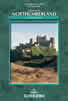 This guidebook contains detailed route descriptions for 36 day walks in Northumberland including the Cheviot Hills. The terrain varies from wild walks and craggy ascents to gentle riverside strolls. Each route ranges from 4 to 16 miles in length and there is the opportunity to link several walks together to create longer treks.
More information
Messaging & Social Media
Message Walking Britain and follow the latest news.

Mountain Weather
Stay safe on the mountains with detailed weather forecasts - for iOS devices or for Android devices.