Bowfell Circular from Great Langdale
Lake District Walk
Nat Park - Lake District - Lake District Southern Fells
Wainwrights - Bowfell
County/Area - Cumbria
Author - Peter Smyly
Length - 7.0 miles / 11.4 km Ascent - 2700 feet / 818 metres
Time - 6 hours 10 minutes Grade - mod/hard
Maps 

| Ordnance Survey Explorer OL6 | Sheet Map | 1:25k | BUY |
| Anquet OS Explorer OL6 | Digital Map | 1:25k | BUY |
| Ordnance Survey Landranger 90 | Sheet Map | 1:50k | BUY |
| Anquet OS Landranger 90 | Digital Map | 1:50k | BUY |
Walk Route Description
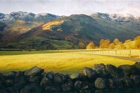
Click image to visit gallery of 7 images.
Bowfell is one of the classic Lakeland mountains and this Lake District walk features a circular route via The Band, returning down the valley of Mickleden. I did this walk on New Year's Day 2006, a day when the mountains were still partly covered with snow, a very cold day but with bracing fresh air and an almost alpine feel about the fells. The photos shown were taken on that day.
Start from the car park at the Old Dungeon Ghyll Hotel and follow the road to Stool End Farm at the foot of the ridge know as The Band. Once you have passed the farm, a track ahead climbs up the ridge. Crinkle Crags appear on the left and the Langdale Pikes, across the Mickleden valley, are to the right. The gradient eases off as the track goes to the right before it going left up to the col where Three Tarns are situated. These tarns offer a foreground to a fine view of the two Scafells (Scafell and Scafell Pike) across the valley to the west.
Next begins a steep route up rocky and rugged terrain to the north with the summit of Bowfell being the next objective. The summit, marked by a cairn, offers a fine view down the valley to the south west towards Eskdale.
The route now descends Bowfell to the north, then north-west down as far as the col between it and Esk Pike. At the col, bear right at Ore Gap and descend the grassy, pathless felllside as Angle Tarn comes into view below on the right with the Langdale Pike seen from the back, therefore showing a less familiar profile. The descent leads to the main path leading from Rossett Ghyll to Great End and beyond and here you turn right along the path to cross the outflow of Angle Tarn before ascending the fellside ahead. At the top of this rise, Rossett Pike is an optional extra as a digression from the main route to the left. Otherwise, it is time to set off down the steep, rocky path going down Rossett Ghyll. The gradients eases off as the Mickleden valley is approached and the necessary height has been lost. A walk of a couple of miles or so (though it may well seem further) back down the Mickleden valley brings you back to the walk's starting point.
Other walks nearby
| Walk 1207 | Great & Little Langdales | moderate | 8.5 miles |
| Walk 2042 | The Langdale Pikes with an ascent of Jack's Rake | very hard | 6.3 miles |
| Walk 2073 | Harrison Stickle, Pike o'Stickle & Rosset Pike | moderate | 8.3 miles |
| Walk 1736 | Langdale Pikes and High Raise FROM New Dungeon Ghyll | mod/hard | 6.1 miles |
| Walk 1144 | Lingmoor Fell | moderate | 8.0 miles |
| Walk 1171 | Pike o' Blisco | moderate | 5.0 miles |
| Walk 2582 | Pike o' Stickle, Harrison Stickle & Pavey Ark | moderate | 6.0 miles |
| Walk 3508 | The Crinkle Crags from Wrynose Pass | easy/mod | 5.0 miles |
| Walk 1134 | Wetherlam and The Carrs | mod/hard | 10.8 miles |
| Walk 2270 | Tilberthwaite and Holme Fell Little Langdale | easy/mod | 5.5 miles |
Recommended Books & eBooks
Hadrian's Wall Path
 Hadrians Wall Path guidebook to walk the 84 mile National Trail. Described in both directions, the main description is west to east between Bowness-on-Solway and Wallsend, Newcastle, with extensions to Maryport and South Shields. With extensive historical information related to this World Heritage site and separate 1:25,000 OS map booklet included.
More information
Lake District: Low Level and Lake Walks
 This guidebook describes 30 of the best low-level walks in the Lake District. From delightful wooded glades and sparkling tarns, to waterfalls and glacier-carved valleys towered over by craggy mountains. The walks described aim to seek out the best walking that the lower areas of the Lake District have to offer.
More information
Messaging & Social Media
Message Walking Britain and follow the latest news.

Mountain Weather
Stay safe on the mountains with detailed weather forecasts - for iOS devices or for Android devices.