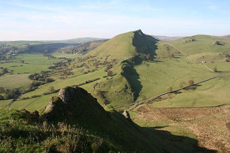
Parkhouse & Chrome Hills from Longnor
Peak District Walk
Nat Park - Peak District - Dove Valley Chrome Hill
County/Area - Staffordshire & Derbyshire
Author - Lou Johnson
Length - 6.7 miles / 10.9 km Ascent - 1250 feet / 379 metres
Time - 4 hours 40 minutes Grade - easy/mod
Maps 

| Ordnance Survey Explorer OL24 | Sheet Map | 1:25k | BUY |
| Anquet OS Explorer OL24 | Digital Map | 1:25k | BUY |
Walk Route Description
Click image to see photo description.
A Peak District walk in the upper Dove Valley that includes Parkhouse and Chrome Hills starting from the Staffordshire village of Longnor. With easily recognisable outlines, these hills are formed from the remains of a coral reef. Until recently, an ascent of Parkhouse Hill was not possible as it was private property. However, the hill is now open access land with freedom to roam.
The start is the market square in Longnor (grid ref. SK088649) where adequate parking is usually available. Walk east along the High Street (signed to Crowdicote, Sheen and Bakewell). Continue past the Olde Cheshire Cheese Inn on your left to reach a lane on the left - Top of th' Edge. Continue along the lane to the end. Take the bridleway through the metal gate on the right (grid ref. SK090650). Follow the concrete track downhill towards the Sewage Works as far as a barn on the left where the concreate track curves to the right. Go left in front of the barn and then right through a gate to Beggar's Bridge over the River Dove and into Derbyshire. Keep straight ahead to reach an access driveway to Underhill.
Turn left and follow the clear route through the buildings at Underhill and onto a lane (grid ref. SK087664). Continue straight ahead along the lane to reach the B5053 at Glutton Bridge. Turn right along this road taking care with traffic. After 200 metres, take the signed footpath on the left across a field. A path comes in from the right and you soon go through a cross-wall (grid ref. SK081667) to enter an open grassy area with Parkhouse Hill on your right.
I will not attempt to describe the ascent route. My route followed sheep trods and paths heading up the east ridge of the hill. This saves a very steep direct ascent up the southern flank of the hill. I then made my way up the ridge and spent some time enjoying the view which includes Chrome Hill and the upper Dove Valley. My descent followed the west ridge zigzagging where necessary on the steep descent to reach an un-fenced road (grid ref. SX077670).
Bear left along the tarmac lane for a short way. On your left, just before a cattle grid, a signed path leads you onto the permissive footpath for an ascent of Chrome Hill. The climb is steep in places with improving view. From the summit, you get a great retrospective view of Parkhouse Hill. Continue by descending the north-western ridge with the path twisting and turning between limestone outcrops. The path is way-marked and leads you across the eastern flanks of Tor Rock to reach the Stoop Farm access road (grid ref. SK064682).
Turn left to a lane. Turn right and follow the lane through Dowel Dale for about two kilometres reaching the cattle grid where you previously left the lane to climb Chrome Hill. 300 metres beyond the cattle grid is a footpath sign on the right (grid ref. SK078668). Go through the small gate, head half left across the field and cross a footbridge over the River Dove. The path then climbs quite steeply uphill to join a driveway, which is followed to the B5053.
Turn right along the road. There is no pavement so please be careful. After 250 metres (grid ref. SK082659), turn left down a track leading to Yewtree Grange. Stay on the concrete past this farm. Just after the last barn bear right onto a rougher track and follow this to a large farm building adjacent to a junction of tracks (grid ref. SK086655). Take the left-hand fork towards Underhill Farm (yes there are more than one!). After 150 metres, go right following a path climbing across the escarpment, which leads back to Lane Head and the centre of Longnor village.
Other walks nearby
| Walk 1861 | Chrome and Parkhouse Hills from Earl Sterndale | easy/mod | 5.0 miles |
| Walk 1862 | Earl Sterndale and High Wheeldon from Longnor | easy/mod | 6.0 miles |
| Walk 2723 | Pilsbury Castle, Hartington & Sheen from Longnor | easy/mod | 9.6 miles |
| Walk 2272 | Flash Circular from Cistern Clough | moderate | 8.0 miles |
| Walk 1043 | Chelmorton & the Monsal Trail | easy/mod | 8.1 miles |
| Walk 3709 | Sparklow, Crowdicote & Pilsbury Circular | easy/mod | 9.0 miles |
| Walk 1652 | Three Shires Head | easy | 4.5 miles |
| Walk 2233 | Flash & Three Shires Head | easy/mod | 6.2 miles |
| Walk 2577 | Hawk's Nest, Goldstitch Moss & Lud's Church | moderate | 8.0 miles |
| Walk 1596 | Lud's Church and Roach End from Gradbach | easy/mod | 4.5 miles |
Recommended Books & eBooks
Walking in the Peak District - White Peak East
 Guidebook describing 42 half-day and day walks in the limestone landscapes of Derbyshire's White Peak, part of the Peak District National Park. One of two volumes, this book covers the east of the region, with potential bases including Bakewell, Eyam, Castleton, Birchover, Matlock and Wirksworth.
More information
Great Mountain Days in the Pennines
 An inspirational guidebook to 50 classic walks on the rolling Pennine landscape. The graded routes, between 6 and 13 miles in length, cover classic Pennine fells and moorland such as Whernside, Ilkley Moor and Pendle Hill; exploring the North and South Pennines, Yorkshire Dales, Howgills and Dark Peak. Many routes are also suited to fell running.
More information
Messaging & Social Media
Message Walking Britain and follow the latest news.

Mountain Weather
Stay safe on the mountains with detailed weather forecasts - for iOS devices or for Android devices.