Dartington from Totnes
Devon Walk
County/Area - Devon
Author - Lou Johnson
Length - 2.5 miles / 4.1 km Ascent - 100 feet / 30 metres
Time - 1 hours 20 minutes Grade - easy
Maps 

| Ordnance Survey Explorer OL20 | Sheet Map | 1:25k | BUY |
| Anquet OS Explorer OL20 | Digital Map | 1:25k | BUY |
| Ordnance Survey Landranger 202 | Sheet Map | 1:50k | BUY |
| Anquet OS Landranger 202 | Digital Map | 1:50k | BUY |
Walk Route Description
Click image to visit gallery of 5 images.
This pushchair friendly walk takes you alongside the River Dart and Bidwell Brook to the craft centre at Dartington. All paths are suitable for normal pushchairs.
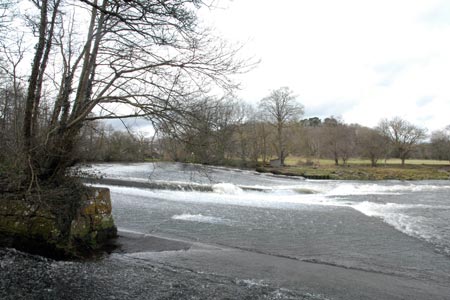
The start is the car park at Totnes Railway Station (grid ref. SX801609). Other parking options are available in the town centre including the cheaper car park at the recreation ground (grid ref. SX803608). Assuming a start from the station, walk through the car park to the opposite end from the main road. You will soon locate the footpath to Dartington. Follow the path to the banks of the River Dart and turn left. The path continues with the river on your right and leads round to a large weir.
Continue along the riverside path to reach a lane. Turn right along the lane, cross Bidwell Brook and the go left on assigned path through woodland. This path leads you parallel to the brook to reach a preserved watermill. Continue along the path to reach the craft centre with shops and cafes (grid ref. SX787622).
The return route is a reverse of the outward walk.
Other walks nearby
| Walk 1323 | Broadsands Beach and Brixham | easy | 4.0 miles |
| Walk 3223 | Avon Dam Reservoir & White Barrows | easy/mod | 5.5 miles |
| Walk 2219 | The Avon Dam Reservoir from Shipley Bridge | easy | 3.5 miles |
| Walk 3641 | Avon Dam & Redlake Tramway from Shipley Bridge | moderate | 7.2 miles |
| Walk 1657 | Huntingdon Warren & Lud Gate from Scorriton | moderate | 7.0 miles |
| Walk 2371 | Kingswear to Brixham | moderate | 10.8 miles |
| Walk 3458 | Sharrah Pool from New Bridge | easy | 3.4 miles |
| Walk 3460 | Dr Blackall's Drive & Ponsworthy | easy/mod | 6.8 miles |
| Walk 3587 | Kingswear from Coleton Fishacre | moderate | 7.0 miles |
| Walk 3387 | Upper Erme Valley & Ugborough Moor | moderate | 9.3 miles |
Recommended Books & eBooks
No suggestions for this area.Messaging & Social Media
Message Walking Britain and follow the latest news.

Mountain Weather
Stay safe on the mountains with detailed weather forecasts - for iOS devices or for Android devices.