Green Burn horseshoe from Grasmere
Lake District Walk
Nat Park - Lake District - Lake District Central Fells
Wainwrights - Calf Crag, Gibson Knott, Helm Crag, Steel Fell
County/Area - Cumbria
Author - Lou Johnson
Length - 7.0 miles / 11.4 km Ascent - 2300 feet / 697 metres
Time - 5 hours 50 minutes Grade - moderate
Maps 

| Ordnance Survey Explorer OL6 | Sheet Map | 1:25k | BUY |
| Anquet OS Explorer OL6 | Digital Map | 1:25k | BUY |
| Ordnance Survey Explorer OL4 | Sheet Map | 1:25k | BUY |
| Anquet OS Explorer OL4 | Digital Map | 1:25k | BUY |
| Ordnance Survey Landranger 90 | Sheet Map | 1:50k | BUY |
| Anquet OS Landranger 90 | Digital Map | 1:50k | BUY |
Walk Route Description
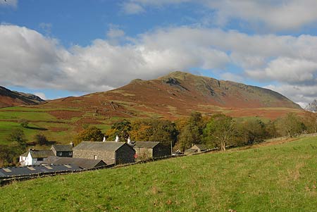
Click image to visit gallery of 12 images.
This Lake District horseshoe walk links the high fells surrounding the valley containing Green Burn. Including four 'Wainwrights', Steel Fell, Calf Crag, Gibson Knott and Helm Crag, the views are generally good and, although there is some wet ground to contend with, the walking straightforward. In poor visibility navigation might be problematic on the section from Steel Fell to Calf Crag so choose a good day to enjoy the walk.
The start is alongside the A591 at Mill Bridge (Grid ref. NY336091) one mile north of Grasmere. Parking is available in two lay-bys although there are restrictions at certain times of the year so an early start is recommended. After parking, leave the main road and take the lane down towards Low Mill Bridge. At the junction (Grid ref. NY333091) turn right and continue along this quiet lane towards Ghyll Foot. Just after crossing Green Burn, bear left up a gravel drive and start to climb. After passing two cottages on your right, go through the gate and turn half right to leave the track and follow the path with the wall on your immediate right.
The climb is steady and the way ahead obvious. However at least two false summits have to be dealt with during the ascent, which offers improving views across Dunmail Raise to Seat Sandal and the Helvellyn range. Cresting the final section of ascent, a cairn comes into view constructed from stone and metal fence posts. From here you are able to get a good idea of the route ahead with almost all of the walk visible from this point.
To continue, walk northwest and then west following the line of the derelict fence. The path is generally easy to follow although in mist it is necessary to stay with the fence line. At a fence junction (Grid ref. NY313113) a short diversion north offers an excellent view north down to Wyth Burn. Passing an unnamed tarn (Grid ref. NY307110), continue across wet ground (mostly avoidable) with the path swinging west and then south to reach the main ridge path on Calf Crag (Grid ref. NY302104).
The route from Calf Crag stays with the ridge that ends at Helm Crag. The path twists and turns along the ridge to reach Gibson Knott before descending to a broad col just before helm Crag. It is worth making a note of the exit path descending northeast towards Green Burn. that will be used after visiting the summit of Helm Crag. With the final ascent to the summit of Helm Crag an easy proposition over the paved path you can soon explore the rocks and crags that give this fell so much character when viewed from the valley. The Grasmere end of the summit area is home to the Lion and the Lamb whilst the other end is home to Lion Couchant (looks like a massive howitzer from the summit).
With exploration of Helm Crag complete, return to the col on its northwestern flank and turn right (northeast) down the steep path towards Green Burn. Care is needed during this descent especially if the grass is wet or icy. With the wall on your left continue the descent to reach a wall junction (Grid ref. NY326096). Cross the wall ahead and continue north across the next field to gain the path on the south bank of Green Burn. Turn upstream to reach a footbridge. Cross the bridge and walk downstream along the track. This leads past the two cottages passed early in the walk and down to Ghyll Foot. Follow the lane towards Grasmere to reach a road junction. Turn left uphill to reach the start.
Other walks nearby
| Walk 1111 | High Raise & Helm Crag | mod/hard | 9.5 miles |
| Walk 3625 | Silver How from Grasmere | easy | 3.2 miles |
| Walk 1154 | Between Grasmere and Langdale | moderate | 9.5 miles |
| Walk 1472 | Alcock Tarn & Rydal Water | easy/mod | 7.0 miles |
| Walk 1565 | Rydal Water & Grasmere circular | easy/mod | 6.0 miles |
| Walk 1682 | Rydal Water & Grasmere | easy/mod | 5.5 miles |
| Walk 1823 | Fairfield Horseshoe & Loughrigg from High Close | mod/hard | 14.0 miles |
| Walk 2026 | Loughrigg from Pelter Bridge near Rydal | easy/mod | 4.0 miles |
| Walk 2715 | Skelwith Bridge & Loughrigg | easy/mod | 5.5 miles |
| Walk 1684 | Lingmoor Fell & Langdale | easy/mod | 7.0 miles |
Recommended Books & eBooks
Outdoor Adventures with Children - Lake District
 Guidebook to 40 outdoor adventures in the Lake District with children under 12, including walking, cycling, orienteering, paddling, boating, hostelling and more. Graded activities for varying age ranges or for families with children of different ages.
More information
Walking the Lake District Fells - Mardale and the Far East
 Part of the Walking the Lake District Fells series, this guidebook covers a wide range of routes to 36 Lakeland summits that can be climbed from the Ullswater, Haweswater, Troutbeck, Kentmere and Longsleddale valleys, with highlights including High Street, Place Fell and the Kentmere fells. Suggestions for longer ridge routes are also included.
More information
Messaging & Social Media
Message Walking Britain and follow the latest news.

Mountain Weather
Stay safe on the mountains with detailed weather forecasts - for iOS devices or for Android devices.