Buckstones and Linsgreave Head from Marsden
South Pennines Walk
Region - South Pennines
County/Area - West Yorkshire - South Pennines
Author - Lou Johnson
Length - 8.8 miles / 14.2 km Ascent - 1420 feet / 430 metres
Time - 5 hours 50 minutes Grade - moderate
Maps 

| Ordnance Survey Explorer OL21 | Sheet Map | 1:25k | BUY |
| Anquet OS Explorer OL21 | Digital Map | 1:25k | BUY |
| Ordnance Survey Landranger 110 | Sheet Map | 1:50k | BUY |
| Anquet OS Landranger 110 | Digital Map | 1:50k | BUY |
Walk Route Description
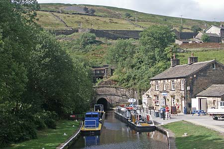
Click image to visit gallery of 12 images.
The village of Marsden is surrounded by wild moorland, which provides the source of the River Colne. In the valleys the remains of the once dominant woollen industry and a rich transport heritage (canals, railways and roads) provide added interest to any visit to the area. This walk uses a mixture of canal towpath, moorland paths, pathless moor and an old packhorse route to explore the high ground to the west of the village. Offering superb views, a glimpse at the Marsden's industrial past and excellent walking, it is wise to choose a fine day as there are sections of the route where it may be a little wet underfoot.
The start is the Standedge Visitor Centre Car Park (Grid ref. SE047118) with its large car park just to the east of the railway station. From here walk west along the canal towpath following the many signs for Standedge Tunnel. Just before the tunnel entrance cross the canal and, keeping to the left of the visitor's centre follow the access road up to the Tunnel End pub. Take the footpath to the left of the pub, which leads up through a garden to the left of a cottage, to a track. Go left along this past Berry Greave. The track becomes a footpath and this leads without any navigational problems to a lane below Lower Green Owlers (Grid ref. SE028126).
Turn right up this tarmac lane passing a house on the right. Take the track on your left toward Hatter Lee. Just before this farmhouse is reached turn right onto the signed footpath (Grid ref. SE028127). This section is well walked and easy to follow. After 300 metres, look out for a pair of stiles in the boundary fence on your right. These are just beyond the stream coming down from Hard Head Clough. The path now becomes much harder to follow but you next objective, Buckstones House, can be seen on the skyline. At first the best line is to follow Hard Head Clough with the path staying close to the stream. This route avoids any wet ground in March Haigh Flat to your left. The path is clear in some sections but fades quite often but generally contours across the hillside towards the A640.
Reaching the main road turn left. Immediately after passing Buckstones House, cross the road and head north keeping the fence to your left. There is a feint path and this is followed to reach a cross fence on Moss Moor Edge (Grid ref. SE009141). Cross this fence and go left (west). Just out of sight to the north is the M62 and Blackstone Edge so a short diversion 100 metres or so north provides a change of scenery. Returning to the fence, continue west keeping the fence on your left. There is no path and the going can be boggy but the worst can be easily avoided by making minor diversions.
Where the fence turns south (Grid ref. SD997139) and you continue keeping it to your left. The fence then turns west leading you to Linsgreave Head before turning south once more to reach the Pennine Way (Grid ref. SD995129). Turn southeast (left) onto the Pennine Way and cross the rolling moorland on a firm well maintained path to reach the A640. Cross over and take the left fork, the right fork is the Pennine Way, which will be followed back towards Marsden. This route is a former packhorse route and you will pass a number of stone markers along the route. The path is clear underfoot and delivers you without further problem to picturesque Eastergate Bridge (Close Gate on OS maps). Cross the bridge and follow the river downstream to Waters Road.
Turn right along Waters Road looking out for an attractive iron sculpture in the wall on your left by Hey Green Hotel. A new footpath has been constructed to the right of Waters Road and this is a more attractive option than walking the road. Reaching the Tunnel End pub, turn right down the access road to the canal. Cross the canal and follow the towpath back to the start.
Other walks nearby
| Walk 2613 | Boundary Walk from Marsden | moderate | 13.0 miles |
| Walk 1587 | Scammonden Reservoir | easy | 4.0 miles |
| Walk 2561 | Digley & Ramsden Reservoirs from Wessenden Head | moderate | 9.5 miles |
| Walk 2719 | Huddersfield's green fringe | easy/mod | 10.0 miles |
| Walk 2518 | Black Hill & Four Reservoirs from near Wessenden Head | moderate | 10.0 miles |
| Walk 1586 | Blackmoorfoot Reservoir | easy | 1.5 miles |
| Walk 2914 | The Pots & Pans from Uppermill | easy/mod | 4.5 miles |
| Walk 2634 | Broadstone Hill & the Cotton Famine Road | moderate | 7.0 miles |
| Walk 1583 | Digley Reservoir | easy/mod | 5.0 miles |
| Walk 1091 | Ripponden and the Calderdale Way | easy/mod | 6.5 miles |
Recommended Books & eBooks
The Pennine Way - the Path, the People, the Journey
 A portrait of the The Pennine Way, Britain's oldest and best known long-distance footpath, stretching 268 miles from the Peak District to the Scottish Borders. This personal, thoughtful and often humorous story of the path's remarkable history, includes the experiences of walkers and local characters on this exhilarating and complex path.
More information
Pennine Way Map Booklet
 Map of the 270 miles (435km) Pennine Way National Trail, between Edale in the Peak District and Kirk Yetholm in the Scottish Borders. This booklet is included with the Cicerone guidebook to the trail, and shows the full route on Ordnance Survey 1:25,000 maps. This popular long-distance route typically takes three weeks to complete.
More information
Messaging & Social Media
Message Walking Britain and follow the latest news.

Mountain Weather
Stay safe on the mountains with detailed weather forecasts - for iOS devices or for Android devices.