Ben Lomond from Rowardennan Pier
Loch Lomond and Trossachs Walk
Nat Park - Loch Lomond and Trossachs
County/Area - Stirling
Author - Lou Johnson
Length - 7.5 miles / 12.2 km Ascent - 3160 feet / 958 metres
Time - 7 hours 0 minutes Grade - mod/hard
Maps 

| Ordnance Survey Explorer OL39 | Sheet Map | 1:25k | BUY |
| Anquet OS Explorer OL39 | Digital Map | 1:25k | BUY |
| Ordnance Survey Landranger 56 | Sheet Map | 1:50k | BUY |
| Anquet OS Landranger 56 | Digital Map | 1:50k | BUY |
Walk Route Description
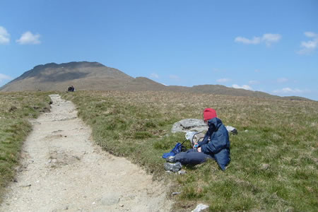
Click image to visit gallery of 5 images.
This walk is justifiably popular offering excellent views on fine days especially over Loch Lomond. The path is well maintained with an ascent taking about 3 hours with the descent usually completed in about 2 hours. This route is popular especially at weekends and when the weather is fine so an early start is to be advised if you want to park at Rowardennan.
The start is the car park at Rowardennan Pier (Grid ref NS358986). This is reached by the lochside road from Drymen. Alternatively you may park at Inverbeg on the western shore of Loch Lomond and take the summer only ferry to Rowardennan.
From the car park take the signed path to 'Ben Lomond' that starts behind the toilets. Climbing on a well maintained path through the forest you reach the open hillside (Grid ref. NS 371991). The views have started to improve and you begin to get some idea of the size of Loch Lomond and realise that it has many small islands.
The next objective is Sron Aonaich which is reached after a steeper section of path. Again there is an incremental improvement in the view with the Trossachs and the Arrochar Alps now included in a superb panorama. The gradient eases for a while until you reach the foot of the ridge that runs southeast from Ben Lomond's summit. This final section of steep uphill work as a complete 360 degree panorama starts to form. All that remains is the fairly gentle final section to reach the summit at 3194 ft. above sea level.
The return route follows the outward path with the views in front of you for the whole descent.
Other walks nearby
| Walk 1493 | WHW - Day 3 - Rowardennan to Inverarnan | moderate | 14.0 miles |
| Walk 1296 | Beinn Eich & Doune Hill | mod/hard | 8.0 miles |
| Walk 1298 | The Cobbler | mod/hard | 7.5 miles |
| Walk 1459 | Ben Arthur ("The Cobbler") | mod/hard | 7.5 miles |
| Walk 2659 | Conic Hill | easy/mod | 4.0 miles |
| Walk 2347 | Duncryne from Gartocharn | easy | 2.0 miles |
| Walk 1492 | WHW - Day 2 - Dryden to Rowardennan | moderate | 15.0 miles |
| Walk 2413 | Ben Venue from Loch Achray | moderate | 8.2 miles |
| Walk 2309 | Ben A'an from Loch Achray | easy/mod | 2.5 miles |
| Walk 2317 | Ben Vorlich from Ardlui | mod/hard | 6.8 miles |
Recommended Books & eBooks
Walking Loch Lomond and the Trossachs
 A guide to walking and scrambling routes in the beautiful Loch Lomond and the Trossachs National Park. Over 70 graded low-level, mid-level and mountain walks taking in hills, glens and picturesque woodland, as well as all of the region's Munro summits. Highlights include Ben Lui, Ben Lomond, the Cobbler and the Arrochar Alps.
More information
Messaging & Social Media
Message Walking Britain and follow the latest news.

Mountain Weather
Stay safe on the mountains with detailed weather forecasts - for iOS devices or for Android devices.