Thenford Hill & Upper Wardington from Middleton Cheney
Northamptonshire Walk
County/Area - Northamptonshire & Oxfordshire
Author - Millennium Way
Length - 7.5 miles / 12.2 km Ascent - 250 feet / 76 metres
Time - 4 hours 0 minutes Grade - easy/mod
Maps 

| Ordnance Survey Explorer 206 | Sheet Map | 1:25k | BUY |
| Anquet OS Explorer 206 | Digital Map | 1:25k | BUY |
| Ordnance Survey Landranger 151 | Sheet Map | 1:50k | BUY |
| Anquet OS Landranger 151 | Digital Map | 1:50k | BUY |
Walk Route Description
Click image to visit gallery of 3 images.
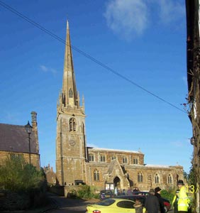
Enjoy a walk on the Millennium Way. The beginning or end of this long distance footpath, either way this is a delightful walk with open country and a gently undulating landscape. During the first half of the walk you enjoy a section of the Millennium Way with the route clearly waymarked with the distinctive black circular waymarkers. This delightful circular walk starts from the ancient church of All Saints in Middleton Cheney dating back to AD1300. Of particular interest are the ceiling paintings by William Morris. Middleton Cheney is some 2 miles east of junction 11 on the M40.
A - Facing the front of All Saints Church the route takes the lane to the left of the church (Church Lane.) Go past Rectory Lane then at the T-junction (opposite a house named Stoneleigh) turn right into Glovers Lane. At the end of the lane the pathway crosses the main road and takes the unmade vehicle track to the right of the "footpath" sign passing between the gardens of domestic properties and ends at a kissing gate into grazing land. Go left to follow Millennium Way waymarker with hedge left, following path around field edge under power lines to find stile. Take stile and go ahead with hedge left to exit by stile to road.
B - Cross road to drive and after 10 paces take stile right signposted "Footpath to Thenford." Follow field edge with fence and stream left, over stile and bridge, and continue ahead with hedge left to field corner with dilapidated stone barn. Take stile left then crossing stone bridge and go right with fence right to gateway. Take gateway and go ½ left across field under power lines aiming for right of partially hidden buildings ahead. At field corner go right with barn conversions and hedge left. At corner continue on same line across field (Aim for right of wood on skyline) to and through hedge gap. Cross field corner to take small timber bridge, over a stream and turn left with hedge left to stile. Take stile and go ½ right across field to road.
C - Cross road and stream and go ahead diagonally right climbing gently up field to top corner gateway / gap joining a farm track. At the top be sure to look back at the glorious 180 degree view with the majestic spire of All Saints Church in the middle distance. Follow track left to pass bungalow right to farm driveway eventually reaching the road. Cross road and take stile into field, continuing with hedge right round field edge to exit by far right field gap. Go ahead over next field to far right corner stile giving access to farm drive. Go left on drive to road. Cross road and take track marked bridleway continuing along to reach Townsend Lane at the crossroads.
D - Here we leave the Millennium Way and turn left along the lane signposted Upper Wardington. Continue along lane to reach the T-junction with glorious views ahead. Turn right following the lane down to cross the bridge which crosses the dismantled railway line. Immediately past the bridge go right through gate and into field walking uphill keeping hedge right towards broken stone wall ahead. On reaching the stone wall go left, to walk with the wall to your right. On reaching corner of field go diagonally left heading for the farm buildings ahead. Go gently downhill through the field towards the waymarker just to the left of the large tree. Bear right here keeping hedge left to cross corner stile then keeping ahead in the next field with hedge left. Veer to the right of the small group of farm buildings ahead and cross corner stile at the end of the row of trees, continuing ahead with fence right. Go over next two stiles and continue towards the village of Upper Wardington. Go between houses then through metal gate to road.
E - Go left along the road then take the footpath right signposted Chacombe through the metal kissing gate. Go diagonally across field towards far corner taking the stile, then ahead with hedge right to take next corner stile. Continue directly ahead through several fields keeping the village of Chacombe ahead and to the left. Proceed with fence right eventually crossing a further stile then through tunnel under dismantled railway, emerging on to a lane. Go straight across following waymarker keeping fence right. Cross wooden bridge over stream then a second bridge rising slightly uphill then entering the charming village of Chacombe.
F - When you reach the road turn right signposted the Jurassic Way and continue on down past the George & Dragon village pub (17th Century) turning left up the main road signposted Middleton Cheney then almost immediately take the gravelled drive on your right past houses and through the metal kissing gate into a small copse. Ignore path to your right but go through another metal kissing gate ahead. Join the surfaced road, continue gently uphill and just before the entrance to Chacombe Park Beaumont take the kissing gate left at end of wooden fencing.
Continue along short woodland path, through kissing gate continuing ahead alongside edge of golf course. Cross a wooden bridge over stream continuing directly ahead across the fairway keeping to the right of the 12th tee where you will find a waymarker leading to a wooden stile. Continue ahead over stile past a large tree in front of you and cross the field heading gently uphill towards power lines with the spire of Middleton Cheney Church coming into view.
Cross over surfaced lane into next field heading diagonally across keeping church spire just ahead. Continue under power lines crossing small wooden bridge to road. Cross over road following footpath to the side of a garage emerging into a large field continuing towards church spire keeping hedge left. Go left where the footpath forks, emerging onto the road. Go left on road then immediately right into Church Lane which brings you back to your start point.
Other walks nearby
| Walk 3252 | Wardington & Cropredy from Chacombe | easy/mod | 7.7 miles |
| Walk 3713 | Cropredy & Chipping Warden Circular | easy/mod | 8.6 miles |
| Walk 1825 | Chipping Warden, Thorpe Mandeville, Culworth Circular | easy/mod | 10.0 miles |
| Walk 1085 | Upper & Lower Boddington | easy/mod | 7.0 miles |
| Walk 3611 | Ashby Gorse from Moreton Pinkney | easy | 5.7 miles |
| Walk 3090 | Woodford Halse, Hellidon & Badby circular | moderate | 13.8 miles |
| Walk 1790 | Byfield, Aston le Walls & Boddington Reservoir | easy/mod | 8.2 miles |
| Walk 3701 | Upper Boddington Circular | easy | 5.5 miles |
| Walk 2276 | Oxford Canal & Stoneton | easy/mod | 7.0 miles |
| Walk 2449 | Canons Ashby Circular | easy | 5.0 miles |
Recommended Books & eBooks
No suggestions for this area.Messaging & Social Media
Message Walking Britain and follow the latest news.

Mountain Weather
Stay safe on the mountains with detailed weather forecasts - for iOS devices or for Android devices.