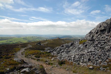
The Stiperstones & Blakemoor Flat from the Knolls
Shropshire Hills Walk
Region - Shropshire Hills
County/Area - Shropshire
Author - Lou Johnson
Length - 5.0 miles / 8.1 km Ascent - 600 feet / 182 metres
Time - 3 hours 10 minutes Grade - easy/mod
Maps 

| Ordnance Survey Explorer 216 | Sheet Map | 1:25k | BUY |
| Anquet OS Explorer 216 | Digital Map | 1:25k | BUY |
| Ordnance Survey Explorer 217 | Sheet Map | 1:25k | BUY |
| Anquet OS Explorer 217 | Digital Map | 1:25k | BUY |
| Ordnance Survey Landranger 137 | Sheet Map | 1:50k | BUY |
| Anquet OS Landranger 137 | Digital Map | 1:50k | BUY |
Walk Route Description
Click image to visit gallery of 9 images.
The quartzite outcrops of the Stiperstones dominate this part of Shropshire. Higher than the Long Mynd to the east, they offer superb views over the surrounding countryside including the Long Mynd, Corndon Hill and mid-Wales. The summit of the ridge is Manstone Rock (536m) and is the second highest point in Shropshire and much more rugged than its competitors.
This walk starts from the Knolls Car Park (grid ref SO369976). Here an information board illustrates the geology and wildlife of the Stiperstones, an area of upland moorland, which is a National Nature Reserve and part of the Shropshire Hills Area of Outstanding Natural Beauty. Go through the gate a follow the broad path uphill towards the outcrops on the skyline. In its early stages the path is easy underfoot but does become rockier later in the walk. After about 400 metres you can bear left off the main path to take in the first significant outcrop of the Cranberry Rock.
Continuing ahead you soon reach Manstone Rock with its trig point precariously balanced on top. It is an easy scramble up to the highest point but do remember the route you took as coming down is often not so easy! Staying on the main ridge path walk north soon passing the Devil's Chair. Continue straight ahead at the next cross path (grid ref.SO371996) where the path becomes a wider track. You pass Shepherd's rock on your right as the track continues across open moorland.
The track starts to descend towards Blakemoor Flat passing close to some fenced fields on your left. Reaching a junction of tracks (grid ref. SJ375008) bear right along an enclosed track. This soon leads back into open country and another junction of tracks (grid ref.SJ380011). Bear right here and contour across the side of the hill with the way ahead always clear on a wide track. Passing above Gittingshay Wood on your left, you reach a fork in the tracks (grid ref. SJ380002). Bear right and start to climb towards the main ridge again.
You soon reach open country again and pass the Shepherd's Rock on your right. Reaching the track used on the outward route, bear left onto the ridge path. You are now retracing your steps past the Devil's Chair and Manstone Rock before dropping down to the car park
Other walks nearby
| Walk 1809 | Shelve & the Stiperstones from The Bog | moderate | 9.0 miles |
| Walk 2083 | Linley Hill and Linley from The Bog | moderate | 8.5 miles |
| Walk 2745 | Betchcott Hills & Pole Bank | moderate | 9.0 miles |
| Walk 1205 | Adstone Hill, Medlicott and the Long Mynd | moderate | 9.5 miles |
| Walk 1072 | Stiperstones low level circular | easy | 4.0 miles |
| Walk 3529 | Stiperstones from Snailbeach | easy/mod | 7.0 miles |
| Walk 1871 | Snailbeach & the Stiperstones | moderate | 7.0 miles |
| Walk 2054 | Linley Hill & Beeches from Wentnor | easy/mod | 7.0 miles |
| Walk 1832 | The Hollies & Poles Coppice from near Habberley | easy/mod | 5.0 miles |
| Walk 2814 | Corndon Hill from Priest Weston | easy | 1.5 miles |
Recommended Books & eBooks
Hillwalking in Shropshire
 Guidebook to 32 walking routes in Shropshire in the West Midlands. The routes range from 3 miles (5km) to 12 miles (19km), taking in highlights such as The Wrekin, Wenlock Edge, Long Mynd and Stiperstones, Castle Ring and Bury Ditches. Many routes start near delightful towns and villages including Church Stretton, Ludlow and Bishops Castle.
More information
Messaging & Social Media
Message Walking Britain and follow the latest news.

Mountain Weather
Stay safe on the mountains with detailed weather forecasts - for iOS devices or for Android devices.