Eastern Carneddau from near Rowen
Snowdonia/Eryri Walk
Nat Park - Snowdonia - Eastern Carneddu
County/Area - Conwy
Author - Lou Johnson
Length - 10.5 miles / 17.1 km Ascent - 2800 feet / 848 metres
Time - 8 hours 0 minutes Grade - mod/hard
Maps 

| Ordnance Survey Explorer OL17 | Sheet Map | 1:25k | BUY |
| Anquet OS Explorer OL17 | Digital Map | 1:25k | BUY |
| Ordnance Survey Landranger 115 | Sheet Map | 1:50k | BUY |
| Anquet OS Landranger 115 | Digital Map | 1:50k | BUY |
Walk Route Description
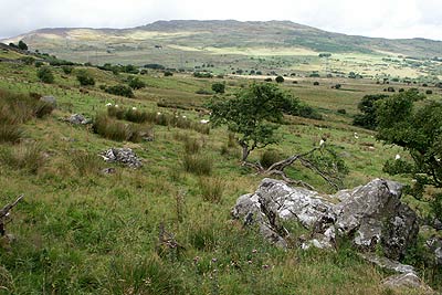
Click image to visit gallery of 12 images.
The north-eastern sector of the Snowdonia National Park contains the largest area of land above 2000 feet in Wales or England. The highest summit is Carnedd Llewelyn (1064 m.) and this walk explores the summits at the eastern end of the ridge that extends from this high point to the sea near Conway. Each of the peaks of the Carneddau have their own character with those included on this route generally grassy with numerous rocky outcrops. Despite their minor status each of the summits visited on this route offers extensive views across the surrounding mountains and coast.
The start of this Snowdonia (Eryri) walk (Grid ref. SH731714) offers limited parking on the roadside and can be reached using narrow lanes from the B5106 Conway to Betws-y-Coed road. After parking, walk back down the lane towards the Conway Valley. Go over the river and continue along the lane to reach a junction (Grid ref. SH742706). Turn right down this track and after 600 metres turn left down the signed footpath. The path is hard to follow and you need to keep referring to the map to keep on course. Eventually you reach an open area (Grid ref. SH743692) where a number of paths and tracks meet. Turn right (south-west) along a track.
Stay on this track taking the right fork (Grid ref. SH735689) where a footpath goes straight on to Tan-y-Bwlch. The track climbs steadily and you can make excellent progress into the Carneddau with some excellent views ahead. On your right rises the minor summit of Pen y Castell and this is the next objective. There is no distinct path to the summit and I opted to stay on the track until a hundred metres or so before the wall (Grid ref. SH725684). I then went right across rough ground to reach the summit, which is marked by a small cairn.
From here the next objective is Drum, which lies to the north of a broad col a few hundred metres northwest of Pen y Castell. Head northwest off the summit and you will soon see a stile in the fence ahead (Grid ref. SH719690). Cross this and follow the clear path beside the fence towards Drum. Reaching the top of the climb, cross the stile and turn right onto the main ridge path.
Do not drop down to the track but stay beside the fence and walk north to Carnedd y Ddelw (Grid ref. SH707705). From here the path continues alongside the fence descending to a track at Bwlch y Ddeufaen. Go straight across the track and start the climb to the summit of Foel Lwyd. This minor peak offers some grand views including much of the route covered on this walk. From Foel Lwyd a short descent brings you to another col from where the last section of uphill work leads you to the summit of Tal y Fan. The views from here are superb especially north-eastwards over the Conway estuary and the Great Orme. From the trig point retrace your steps to the col and turn left downhill back to the start.
Other walks nearby
| Walk 2547 | Carnedd Llewelyn from near Rowen | mod/hard | 12.0 miles |
| Walk 2497 | Druid Circle, Moelfre and Foel Lus from Penmaenmawr | easy/mod | 6.0 miles |
| Walk 1635 | Garnedd Uchaf & Llyn Eigiau | mod/hard | 9.0 miles |
| Walk 2542 | Foel Grach & Llyn Eigiau | moderate | 8.5 miles |
| Walk 2638 | Craig Eigiau, Melynilyn & Dulyn Resrs nr. Tal-y-Bont | moderate | 7.0 miles |
| Walk 3047 | The Carneddau from Llyn Eigiau | hard | 10.0 miles |
| Walk 2821 | Melynllyn & Dulyn Reservoir from Llyn Eigiau parking | easy/mod | 5.5 miles |
| Walk 2346 | Yr Orsedd ridge from near Bont Newydd | moderate | 4.8 miles |
| Walk 1435 | Sychnant Pass, Alltwen, Penmaen-Bach, & Conwy Mountain | easy/mod | 3.0 miles |
| Walk 3604 | Foel Lus & Jubilee Path from Sychnant Pass | easy/mod | 5.9 miles |
Recommended Books & eBooks
Snowdonia: 30 Low-level and easy walks - South
 Guidebook describing 30 walks in Snowdonia, Wales. Routes are mostly low level and on clear paths and showcase the region's beautiful scenery and rich history and culture. Part of a 2-volume set, this southern volume includes Trawsfynydd, Bala, Dolgellau, Machynlleth, the Harlech Coast and the valleys of the Mawddach and Dyfi.
More information
Snowdonia: 30 Low-level and easy walks - North
 Guidebook describing 30 walks in Snowdonia, Wales. Routes are mostly low level and on clear paths and showcase the region's beautiful scenery and rich history and culture. Part of a 2-volume set, this northern volume includes the Snowdon area, the Ogwen and Conwy Valleys, Betws-y-Coed, Beddgelert, Ffestiniog and the coast.
More information
Messaging & Social Media
Message Walking Britain and follow the latest news.

Mountain Weather
Stay safe on the mountains with detailed weather forecasts - for iOS devices or for Android devices.