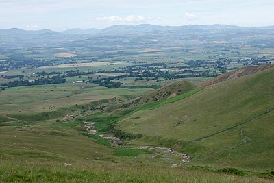
Cross Fell & Great Dun Fell from Kirkland
North Pennines Walk
Region - North Pennines
County/Area - Cumbria - North Pennines
Author - Lou Johnson
Length - 12.0 miles / 19.5 km Ascent - 3100 feet / 939 metres
Time - 9 hours 10 minutes Grade - mod/hard
Maps 

| Ordnance Survey Explorer OL31 | Sheet Map | 1:25k | BUY |
| Anquet OS Explorer OL31 | Digital Map | 1:25k | BUY |
| Ordnance Survey Landranger 91 | Sheet Map | 1:50k | BUY |
| Anquet OS Landranger 91 | Digital Map | 1:50k | BUY |
Walk Route Description
Click image to visit gallery of 12 images.
The Pennine Hills form the backbone of England and Cross Fell is their highest point. This walk includes some wild country and it is recommended that a fine day is chosen before setting out. Even in fine weather Cross fell can attract a covering of cloud so it is essential that you have good navigational skills, an appropriate map and suitable equipment.
The start is the small village of Kirkland (Grid ref. NY646324) where a number of roadside parking opportunities exist. Having parked continue up the lane past Kirkland Hall onto a clear track. Ahead lies the massive bulk of Cross Fell rising in layers to the summit plateau (893 m). The track rises gently at first but steepens after Kirkland Beck. Where the gradient becomes more taxing, the track loops up the hillside before the gradient eases. Where the track goes sharp left (Grid ref. NY 671 348) continue ahead on a clear path past the decaying corrugated iron bothy to reach the Pennine Way (Grid ref. NY 684 352).
Turn right and continue climbing to reach Cross Fell's summit plateau. There are a number of cairns indicating the path with the summit occupied by a trig column with a large wind-shelter close to hand. The view is superb with the Vale of Eden below and the Lakeland Fells occupying the horizon with Blencathra easily identified.
Leave the summit in a southeasterly direction following the Pennine Way south. You descend through rough scree to Tees Head (the source of the River Tees) to where you will return after visiting the next two summits. The Pennine Way in this area is well maintained and progress onto Little Dun Fell and Great Dun Fell (with its radar station) is fast.
The views from Great Dun Fell are much the same as those from Cross Fell but you do get a better look at the rough moorland to the southeast that stretched into Teesdale. Turning north, retrace your steps to Tees Head (Grid ref. NY 696 338) and locate the indistinct path back into the Vale of Eden. Close to it is hard to see but from 50 metres away you can see a distinct line in the moorland.
Having located this path descend southwest across the southern flank of Cross Fell. In places the going is a little wet underfoot but in general the path is easy to follow and distinct. Descend steeply over Wildboar Scar and continue past Grumply Hill to reach sheep pens after crossing to the north side of Crowdundle Beck (Grid ref. NY 661 317). Continue between wall to reach Wythwaite. Turn right here and follow the track towards Ranbeck Farm. Just before reaching the latter turn left along the track to exit on the road in Kirkland.
Other walks nearby
| Walk 1715 | Dufton Pike & Dufton | easy | 5.0 miles |
| Walk 1339 | High Cup Nick | moderate | 10.5 miles |
| Walk 3011 | Dufton Pike | easy/mod | 5.5 miles |
| Walk 3070 | Knock Fell & High Cup Nick | mod/hard | 12.0 miles |
| Walk 3421 | High Cup Nick via Middle Tongue | moderate | 9.3 miles |
| Walk 1784 | Rutter Force & Hoff Beck | easy/mod | 8.0 miles |
| Walk 3758 | Tynehead and Ashgill Force from near Garrigill | easy/mod | 8.2 miles |
| Walk 1084 | Garrigill, Alston & Nenthead | moderate | 13.1 miles |
| Walk 2453 | Askham Fell from Lowther Castle | easy/mod | 7.4 miles |
| Walk 2195 | Alston & Garrigill | easy/mod | 8.7 miles |
Recommended Books & eBooks
Walking the Lake District Fells - Patterdale
 Part of the Walking the Lake District Fells series, this guidebook covers a wide range of routes to 35 Lakeland summits that can be climbed from Ambleside, Grasmere and Patterdale and the Thirlmere and Ullswater valleys, with highlights including Helvellyn and Fairfield. Suggestions for longer ridge routes are also included.
More information
Walking the Lake District Fells - Keswick
 Part of the Walking the Lake District Fells series, this guidebook covers a wide range of routes to 30 Lakeland summits that can be climbed from Keswick, Whinlatter, Bassenthwaite, Caldbeck, Mungrisdale and Threlkeld, with highlights including Skiddaw and Blencathra. Includes suggestions for longer ridge routes.
More information
Messaging & Social Media
Message Walking Britain and follow the latest news.

Mountain Weather
Stay safe on the mountains with detailed weather forecasts - for iOS devices or for Android devices.