Walk 3092 - printer friendly version
Malham Cove, Malham Tarn & Watlowes Walk
Author - Lou Johnson
Length - 4.4 miles / 7.2 km
Ascent - 450 feet / 136 metres
Grade - easy
Start - OS grid reference SD894658
Lat 54.0879980 + Long -2.1635403
Postcode BD24 9PU (approx. location only)
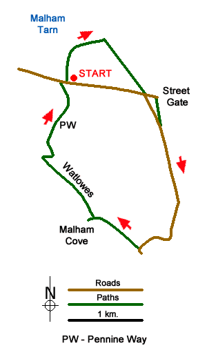
The limestone scenery between Malham Tarn and Malham Cove is some of the finest in Britain. This short Yorkshire Dales walk offers the opportunity to explore this area avoiding many of the crowds that use the approach from Malham village. The start is the free car park near Malham Tarn (grid ref. SD894658) which can be reached using lanes from Malham and Settle.
After parking, walk north towards the shores of Malham tarn and bear right with the tarn to your left. Continue ahead to the first area of woodland (Lings Plantation) and then take a clear track on the left. This track leads southeast and soon passes another small area of woodland which is passed on your left. Continue along this track to regain the tarmac lane from the carpark. Turn left leaving the lane and walk the short distance along the lane to reach Street Gate (grid ref. SD905656).
Turn right along the wall which should be to your left and continue to regain the tarmac lane after 350 metres. Continue south along this quiet lane for just over a mile. The walking is easy with improving views especially as you descend towards Malham. After a couple of bends you reach a ladder stile on your right (grid ref. SD902637) with a footpath finger post. Cross this stile and follow the clear path across grass to soon be rewarded with a glorious view of the limestone pavement at the top of Malham Cove. Continue ahead through a wall (grid ref. SD897641).
From this point, you can explore the limestone pavement and enjoy the views down Malhamdale. Return to the wall. Do not cross the wall and turn left keeping the wall to your right. You are now entering Watlowes dry valley with its impressive limestone crags. You are also following a section of the Pennine Way long distance footpath. The path is initially flat but soon gains height passing through a rocky section and climbing a series of rock steps to reach a junction of paths (grid ref. SD891649).
Turn sharp left at the top of the climb out of Watlowes staying on the Pennine Way. Almost immediately you have a fine view looking south down Watlowes dry valley. Stay on the clear path keeping the wall to your right. You will soon pass the point where the stream leaving Malham Tarn disappears underground and shortly after the lane adjacent to where you parked. In season, a refreshment van and an ice-cream van are usually here.
Messaging & Social Media
Message Walking Britain and follow the latest news.

Mountain Weather
Stay safe on the mountains with detailed weather forecasts - for iOS devices or for Android devices.