High Tove & Blea Tarn from Armboth
Lake District Walk
Nat Park - Lake District - Lake District Central Fells
Wainwrights - High Tove
County/Area - Cumbria
Author - Lou Johnson
Length - 7.6 miles / 12.4 km Ascent - 2100 feet / 636 metres
Time - 5 hours 50 minutes Grade - moderate
Maps 

| Ordnance Survey Explorer OL5 | Sheet Map | 1:25k | BUY |
| Anquet OS Explorer OL5 | Digital Map | 1:25k | BUY |
| Ordnance Survey Explorer OL4 | Sheet Map | 1:25k | BUY |
| Anquet OS Explorer OL4 | Digital Map | 1:25k | BUY |
Walk Route Description
Click image to see photo description.
This sometimes energetic Lake District walk takes you from the shores of the Thirlmere Reservoir over High Tove following the path down towards Watendlath. The route then turns south passing Blea Tarn to re-cross the ridge down to Dobgill Bridge where the concessionary path on the western shore of Thirlmere is followed north to Armboth. The route does cross some boggy terrain so do chose a period of dry weather to undertake the walk. Despite the soft terrain (in places) you will be rewarded with some fine views especially west to Grasmoor, Great Gable and Scafell Pike.
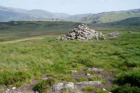
The start is the car park at Armboth (grid ref. NY305171) which can be reached from the A591 between Grasmere and Keswick. After parking, walk up to the road and turn right. After a few metres take the signed footpath through a kissing gate on the left. Go over the stone bridge and continue through a gate. The path then passes through a sheep pen to follow a fence on your left. The climb is steep in places with some zig-zags to ease the ascent. Reaching the top corner of the forestry area you enter open fell staying on the path to the summit of High Tove (grid ref. NY288165). This is a perfect place for a refreshment stop.
From the summit head west to the gate in the fence and maintain direction to start the descent to Watendlath, which soon comes into view. Reaching a gate (grid ref. NY279163) you have the option of continuing down into Watendlath for well-earned refreshments but need to return to the gate to continue. This will add about 400 feet of ascent to the walk. Do not go through the gate but turn south (left) along a bridleway which parallels a wall on your right. Reaching a wall corner where the wall goes right (grid ref. NY280161), cross the stream and bear left where the tracks forks. The route follows a series of small cairns towards a rocky outcrop which you pass to the right. Continue climbing to reach the north-eastern shores of Blea Tarn and continue uphill to reach a gate in the ridge fence (grid ref. NY296139).
From the fence, follow the path downhill to the forest boundary (grid ref. NY302138). Descend to a fork, then go right off main track over a boardwalk to reach a wide forest track, by a stream. At the next junction follow the path on the right signed to Harrop Tarn. Continue down to pass the Tarn (on your right). Just before a stream crosses the track (grid ref. NY312136), turn left along a waymarked path. Pass the waterfall on Dob Gill (to your right) and continue what becomes a well-made track that zig-zags down the fellside. Fork left when you reach a stone wall and descend to Dobgill car park (grid ref. NY316140).
The return to the start offers three options. You can either turn left along the road and continue back to the start - an easy walk of just over 2 miles. Alternatively, you can follow the road to Hause Point, where you stay on the road through the cutting and pick up the shore path for the remainder of the walk back to the start. This option offers easy road walking and then a reasonably easy path along the shore. The third option is to follow the permissive path from Dobgill to the Hause along a path that is slow and not that easy. This path re-joins the road just before the cutting mentioned in the second option.
Other walks nearby
| Walk 1247 | Helvellyn & Raise from Swirls | mod/hard | 7.0 miles |
| Walk 2025 | Helvellyn & Wythburn from Swirls | mod/hard | 8.5 miles |
| Walk 2019 | Raven Crag, the Benn & Shoulthwaite Gill near Thirlmere | easy/mod | 4.0 miles |
| Walk 2032 | Great How, a short ascent above Thirlmere | easy | 2.0 miles |
| Walk 1158 | High Rigg | easy | 5.5 miles |
| Walk 2005 | High Rigg & Legburthwaite | easy | 5.5 miles |
| Walk 2049 | Calfhow Pike & the Dodds from Legburthwaite | moderate | 7.5 miles |
| Walk 2524 | Thirlmere Circular | easy | 5.0 miles |
| Walk 2525 | Standing Crag & Dock Tarn from Watendlath | moderate | 7.0 miles |
| Walk 2526 | Standing Crag, Ullscarf & Borrowdale | mod/hard | 10.0 miles |
Recommended Books & eBooks
Great Mountain Days in the Lake District
 An inspirational guidebook to 50 challenging walks on the high fells of the Lake District. The graded circular routes, between 4 and 14 miles in length, cover classic Lakeland summits like Fairfield, Scafell Pike, Great Gable and Blencathra, to the lesser-known High Spy, King's How and Brund Fell.
More information
Walking the Lake District Fells - Buttermere
 Part of the Walking the Lake District Fells series, this guidebook covers a wide range of routes to 32 Lakeland summits that can be climbed from the Buttermere, Lorton and Newlands valleys, with highlights including Haystacks, High Stile, Grasmoor and the fells of the Coledale Round. Suggestions for longer ridge routes are also included.
More information
Messaging & Social Media
Message Walking Britain and follow the latest news.

Mountain Weather
Stay safe on the mountains with detailed weather forecasts - for iOS devices or for Android devices.