Walk 3241 - printer friendly version
Kinver Edge & Holy Austin Rock Walk
Author - Lou Johnson
Length - 2.6 miles / 4.2 km
Ascent - 400 feet / 121 metres
Grade - easy
Start - OS grid reference SO836836
Lat 52.4501090 + Long -2.2427394
Postcode DY7 6DL (approx. location only)
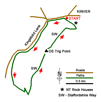
Kinver Edge provides some easy walking with excellent views and this route also offers the chance to visit the Rock Houses owned by the National Trust located in the sandstone outcrop of the Holy Austin Rock. Parking is available on Compton Road which is the nearest parking for the Rock Houses and marked by a National Trust sign (grid ref. SO836836).
After parking walk along Compton Road with the Rock Houses on your left. The road is quite narrow for a short section so care is needed. At the first road junction turn left into Kingsford Lane. Turn left almost immediately onto a footpath into the woods bearing right at the first junction onto a path that has intermittent blue marker posts. It is helpful to have the National Trust walks leaflet as this identifies the onward path. If not, follow the path through pleasant woodland walking parallel to Kingsford Lane which is close by to your right. You will soon pass a car park on the lane. Continue along the path for a further kilometre to reach a clear wider path coming in from the right (grid ref. SO826825). This is adjacent to a more open area of woodland. This section took about 20 minutes or so of steady walking.
Continue ahead. You will reach a path junction after about 150 metres. Take the left-hand fork uphill to reach T-junction marked by purple markers (grid ref. SO828822). Turn left along this wider path. At the first junction turn sharp right uphill to reach the main path running along the crest of Kinver Edge with a footpath fingerpost on the junction (grid ref. SO829822). Turn left (north) along the Staffordshire Way enjoying views to the Clent Hills on your right and across the Severn Valley to the Shropshire Hills on your left.
Continue along the ridge path passing an Ordnance Survey Trig Column. The wide path leads past the remains of a fort to reach the viewpoint with a topography (grid ref. SO836834). To return to the start, bear right down steps to pass the entrance to the National Trust Rock Houses on your right. These are worth a visit and there is also a café and toilets. To return to the start stay on the path which leads back to the parking area beside Compton Road.
Messaging & Social Media
Message Walking Britain and follow the latest news.

Mountain Weather
Stay safe on the mountains with detailed weather forecasts - for iOS devices or for Android devices.