Wardington & Cropredy from Chacombe
Northamptonshire Walk
County/Area - Northamptonshire & Oxfordshire
Author - Lou Johnson
Length - 7.7 miles / 12.5 km Ascent - 400 feet / 121 metres
Time - 4 hours 20 minutes Grade - easy/mod
Maps 

| Ordnance Survey Explorer 206 | Sheet Map | 1:25k | BUY |
| Anquet OS Explorer 206 | Digital Map | 1:25k | BUY |
Walk Route Description
Click image to see photo description.
This circular walk starts from Chacombe in Northamptonshire and continues into adjacent Oxfordshire. The route includes a section of the Jurassic Way, several attractive villages, the Oxford Canal and some pleasant countryside.
The start is the village of Chacombe where limited parking is available by the small green by the George & Dragon pub (grid ref. SP491438). Facing the pub, walk to the right into Silver Street. Go past a couple of thatched cottages and take the signed footpath on the left. Go through the gate and turn right along the field edge. You are now on the Jurassic Way, which is followed for a mile and a quarter to Upper Waddington. The route is easy to follow. After going under an old railway line, the path maintains direction across a number of fields to reach Thorpe Road on the southern edge of Upper Waddington (grid ref. SP497457).
Turn left along Thorpe Road into the village. Reaching a small village green (grid ref. SP496460) where Thorpe Road bends to the left, keep straight ahead. The road soon forks, bear to the left here past the entrance to Simcoes Farm. Almost immediately turn right onto a path across a small green with a house to your right. You will see the footpath sign in the corner of the green. There is a small stream on your left. Follow this up a small valley, keeping the stream on your left. Do not turn left where a track fords the stream. The path leads to a stile onto a lane (grid ref. SP492469).
Turn left along the lane to reach the Hare and Hounds pub and the A361. Turn right along the A361 towards Daventry. Care is needed on this section of main road. After 150 metres, take the signed bridleway on the left. The path keeps the hedge on your right. Keep straight ahead. The track soon reaches an area of trees. Go through the plantation, cross the river bridge and continue to reach a concrete cross track (grid ref. SP478473). Cross this track and continue ahead now with the hedge to your left. After just under 200 metres, bear half right across the field to a gap in the hedge and adjacent footpath sign. Entering the next field, maintain direction aiming just to the right of a small copse. Go through the metal gate to reach a lane (grid ref. SP473478). Turn left along the lane.
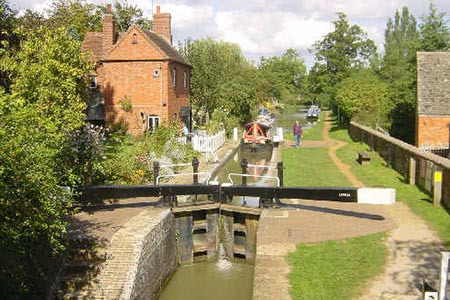
You soon reach the Oxford canal at Broadmoor Lock. Turn right off the road just before the canal and then go immediately left under the bridge to join the towpath. Follow the towpath (canal on your right) to reach picturesque Cropredy Lock. Continue along the canal to reach Bridge 156 (grid ref. SP471450). Take the steps up from the towpath and head for the footbridge over the River Cherwell. The way ahead is through a gate in the hedge. Continue ahead across the next field aiming for a pair of gates in the opposite hedge. Go through the left-hand gate, and with the hedge on your right, continue to reach a farm track (grid ref. SP479451). Turn left up the track to farmyard where you cross a stile and go through a kissing gate to reach a lane (grid ref. SP480453).
Turn right along the lane and continue to a junction with the A361. Cross the road with care and take the signed footpath opposite keeping the hedge on your right. After 600 metres alongside the hedge you reach a small wooden footbridge across a field drain (grid ref. SP486448). From this small bridge bear half right across the next field to a lane (grid ref. SP487446). Turn left and then right at the junction towards Chacombe. After 600 metres of road walking you reach a stile on the left just past Glen Meadows Farm. Ignore this stile and continue along the road to the next stile on the left (grid ref. SP489441). Cross the stile and cross the small field to another stile which leads you into Church Lane from where you can continue back to the start.
Other walks nearby
| Walk 3042 | Thenford Hill & Upper Wardington from Middleton Cheney | easy/mod | 7.5 miles |
| Walk 3713 | Cropredy & Chipping Warden Circular | easy/mod | 8.6 miles |
| Walk 1825 | Chipping Warden, Thorpe Mandeville, Culworth Circular | easy/mod | 10.0 miles |
| Walk 1085 | Upper & Lower Boddington | easy/mod | 7.0 miles |
| Walk 1790 | Byfield, Aston le Walls & Boddington Reservoir | easy/mod | 8.2 miles |
| Walk 3701 | Upper Boddington Circular | easy | 5.5 miles |
| Walk 2276 | Oxford Canal & Stoneton | easy/mod | 7.0 miles |
| Walk 3090 | Woodford Halse, Hellidon & Badby circular | moderate | 13.8 miles |
| Walk 3611 | Ashby Gorse from Moreton Pinkney | easy | 5.7 miles |
| Walk 1774 | Priors Hardwick & Wormleighton Circular | easy/mod | 8.0 miles |
Recommended Books & eBooks
No suggestions for this area.Messaging & Social Media
Message Walking Britain and follow the latest news.

Mountain Weather
Stay safe on the mountains with detailed weather forecasts - for iOS devices or for Android devices.