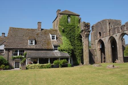
The Hatterall Ridge from Llanthony Priory
Brecon Beacons/Bannau Brycheiniog Walk
Nat Park - Brecon Beacons - Brecon Beacons East
County/Area - Monmouthshire & Herefordshire
Author - Lou Johnson
Length - 10.0 miles / 16.3 km Ascent - 1820 feet / 552 metres
Time - 6 hours 50 minutes Grade - very hard
Maps 

| Ordnance Survey Explorer OL13 | Sheet Map | 1:25k | BUY |
| Anquet OS Explorer OL13 | Digital Map | 1:25k | BUY |
| Ordnance Survey Landranger 161 | Sheet Map | 1:50k | BUY |
| Anquet OS Landranger 161 | Digital Map | 1:50k | BUY |
Walk Route Description
Click image to visit gallery of 9 images.
This walk in the Black Mountains explores one of the main ridges in this part of the Brecon Beacons National Park. The start is the free car park adjacent to Llanthony Priory (Grid ref SO288278) where there are toilets and refreshments available in season. From here the route goes north following a route just above the valley floor before climbing up onto the ridge and continuing for just over 4 miles along the ridge. The final section is s steady descent into the valley.
From the car park take the exit road past the entrance to the ruined Priory on your right. Where the access road bears left, continue straight ahead. Go through a gate and across a field to reach a lane. Walk past the pub on your left. Bear left at the lane junction. Walk up this lane turning left up an enclosed path (Grid ref. SO281279) following the course of a small spring. Go through two gates and turn right following a fence on your right. This leads you up valley contouring the hillside. The path descends to a footpath sign, crosses a stream and then continues to reach Nant-y-carnau (Grid ref. SO272285).
Stay on the waymarked bridleway. This continues bypassing above Sychtre Farm to reach Cae-waun (Grid ref. SO272293). From here a footpath continues and reaches Penyworlod Farm. The path briefly enters the farm yard from where you take the access road down to the lane (Grid ref. SO265305). Take the track opposite, crossing the bridge over the river and then climbing uphill along a rather badly maintained sunken path to reach a lane (Grid ref. SO266308). Turn left along the lane passing The Vision Farm.
Just past the farm take the signed path on your right. This path leads steeply through some trees to reach open country at a stile (SO265312). The temptation is to go straight uphill but it is better to turn right to follow the clear path which zigzags up the hillside. The path gains height quickly and easily and soon levels out. Reaching open moorland there are a few places where there is a choice of path. Stay on the most obvious and continue ahead to reach the main Offa's Dyke Path on the ridge.
Turn right. You now have over four miles of easy high level walking. The views are good in both directions. You need to pass two trig columns - the first at 610m (Grid ref. SO280307) and the second at 552m (Grid ref. SO304278). The ridge path is clear and easy to follow. After passing the second trig point the ridge path loses about 200 feet in altitude to reach a junction of paths (Grid ref. SO307269). Turn sharp right here to follow the path descending obliquely across the hillside initially with a wall on your left.
Continue the descent to reach an information board (Grid ref. SO295279). Turn left here and descend through woods. The path leads across a field to reach the gate you passed through at the start of the walk. Go through the gate and back to the start.
Other walks nearby
| Walk 3622 | Llanthony Priory from Longtown | mod/hard | 7.0 miles |
| Walk 3204 | Hay Bluff & Twmpa | moderate | 10.3 miles |
| Walk 2935 | Llanthony Priory from Capel-y-ffin | easy/mod | 7.7 miles |
| Walk 1660 | Craswall Priory & Hay Bluff | easy/mod | 6.0 miles |
| Walk 1238 | Hay Bluff & Twmpa Circular | moderate | 6.0 miles |
| Walk 1271 | Sugar Loaf circular | moderate | 6.0 miles |
| Walk 1664 | The Sugar Loaf | easy | 3.5 miles |
| Walk 1106 | Waun Fach | mod/hard | 7.5 miles |
| Walk 2065 | Waun Fach & Y Grib from Pengenfford | moderate | 6.5 miles |
| Walk 3717 | Table Mountain from Crickhowell | easy/mod | 5.0 miles |
Recommended Books & eBooks
Walking in Carmarthenshire
 Guidebook to 30 walking routes (2 to 10 miles) in Carmarthenshire, south Wales, including sections of Carmarthenshire Coast Path. Walks for all abilities, including coastal, river, forest and hill walks in Cambrian Mountains, Tywi Valley, Y Mynydd Du (Black Mountains) and Brecon Beacons. Easy access from Bristol, Cardiff and Swansea.
More information
Walking on the Brecon Beacons
 45 circular day walks are described in this guidebook to the Brecon Beacons National Park. From west to east, Mynydd Du, Fforest Fawr, the Brecon Beacons and the Black Mountains these mountain and valley routes offer many options, highlighting the natural features. The walks described explore dramatic waterfalls, wooded gorges and upland valleys.
More information
Messaging & Social Media
Message Walking Britain and follow the latest news.

Mountain Weather
Stay safe on the mountains with detailed weather forecasts - for iOS devices or for Android devices.