Swanlake Bay from Manorbier
Pembrokeshire Coast Walk
Nat Park - Pembrokeshire Coast
County/Area - Pembrokeshire
Author - Lou Johnson
Length - 4.8 miles / 7.8 km Ascent - 800 feet / 242 metres
Time - 3 hours 10 minutes Grade - easy/mod
Maps 

| Ordnance Survey Explorer OL36 | Sheet Map | 1:25k | BUY |
| Anquet OS Explorer OL36 | Digital Map | 1:25k | BUY |
Walk Route Description
Click image to see photo description.
This walk from Manorbier explores a section of beautiful coast using the Pembrokeshire Coast Path for much of the way. The route includes dramatic rock formations, the headland of Priest's Nose, Manorbier Beach and Swanlake Bay. The walk is easy to follow with clear paths. There are places with unprotected steep drops off the path to the sea. You can also combine this walk with a visit to Manorbier Castle.
The start is the pay and display beach car park opposite the castle (grid ref. SS064977). After parking exit the car park and turn right passing the walls of the castle on your left. Continue uphill into the centre of Manorbier to reach the B4585 where you turn right. Just past the Castle Mead Hotel, turn right again and continue along the lane. Where the lane bears right, continue straight ahead onto a track which is a signed footpath (grid ref. SS069977). After 200 metres take the signed footpath, crossing the stile on the right. Pass Hill Farm on your right and continue along the clear footpath to reach the sea.
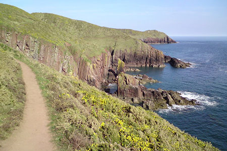
Turn right through the gate and join the Pembrokeshire Coast Path (also the Wales Coast Path). The path climbs to the cliff top with the near vertical beds of sandstone making an impressive sight. The path continues close to the cliff edge where care is needed. The view ahead includes Stackpole and Trewent Point. Continue past the head of two rocky chasms cut into the cliff. Continue around the headland of the Priest's Nose Manorbier Beach comes into view.
Continue down some steps and cross the back of the beach to cross a small footbridge over a stream. Follow the path head which climbs up below a road. Continue past the parking to follow the onward path. You soon reach a tarmac drive. Continue ahead keeping to the left of the building. Pass through a gate and take time to look back to the Priest's Nose. Ahead is a pleasant but less dramatic section of coast. The path soon climbs a small ridge at the end of which you have a wonderful view of Swanlake Bay.
Pass through a gate with the beach to your left (grid ref. SS046980), fork right and follow the path as it turns sharp right. The path bears left following a hedge on your right. Turn right through a gate to East Moor Farm where you bear right past buildings to another gate. Cross a track and continue along a clear path with a high hedge on your left. Follow this path to reach a road. Turn right and continue above the beach to the car park used at the start of the walk.
Other walks nearby
| Walk 3475 | Caldey Island Circular | easy | 3.0 miles |
| Walk 3364 | The Stackpole Estate from Stackpole Quay | easy | 5.0 miles |
| Walk 3366 | Bosherston Lily Ponds | easy | 3.4 miles |
| Walk 1209 | Saundersfoot & Tenby | easy/mod | 4.5 miles |
| Walk 3365 | Bosherston Lily Ponds, Broad Haven & St. Govan's Chapel | easy/mod | 5.0 miles |
| Walk 3495 | St. Govan's Chapel, Bosherston & Elegug Stacks | moderate | 9.6 miles |
| Walk 3498 | Freshwater West & Angle | moderate | 8.7 miles |
| Walk 3369 | Pendine to Amroth Coast Path | moderate | 5.7 miles |
| Walk 3497 | Angle Peninsula | easy | 3.7 miles |
| Walk 2485 | Broad Haven & Druidston Circular | easy/mod | 4.9 miles |
Recommended Books & eBooks
The Wales Coast Path
 A single guidebook to walking the whole Wales Coast Path - 1400km (870 miles) the length of Wales from Chester to Chepstow, including Anglesey, described in 57 stages. The route passes through the Snowdonia and Pembrokeshire National Parks and many AONBs and can be linked with the Offa's Dyke Path for a complete circuit of Wales.
More information
Messaging & Social Media
Message Walking Britain and follow the latest news.

Mountain Weather
Stay safe on the mountains with detailed weather forecasts - for iOS devices or for Android devices.