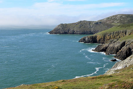
Pen y Cil & Porth Meudwy from Mynydd Mawr
Llyn Peninsula Walk
Region - Llyn Peninsula
County/Area - Gwynedd - Llyn Peninsula
Author - Lou Johnson
Length - 5.7 miles / 9.3 km Ascent - 1300 feet / 394 metres
Time - 4 hours 10 minutes Grade - moderate
Maps 

| Ordnance Survey Explorer 253 | Sheet Map | 1:25k | BUY |
| Anquet OS Explorer 253 | Digital Map | 1:25k | BUY |
Walk Route Description
Click image to see photo description.
This Llŷn Peninsula explores the most westerly headland in the area, which lies west of Aberdaron. The route uses the Wales Coast Path to explore the dramatic and rugged coastline with views across to Bardsey Island. The walk also crosses the heathland of Mynydd Mawr which is managed by the National Trust. It is worth noting that there is a stiff climb at the end of the walk.
The start is the small car park close to the viewing point near the summit of Mynydd Mawr (grid ref. SH140258) which can be reached by following a series of lanes from Aberdaron. Before starting the walk, it is worth visiting the viewing point to get some idea of the route about to be undertaken. Having taken in the view, join the Wales Coast Path by descending a concrete path which lies to the left of the viewing point when facing the sea. Head down a flight of steps to reach the foundations of the old coastguard station. Keep ahead following white topped posts (standard waymarking on the coast path) and bear left along the cliff tops.
The well-waymarked path offers a great view to Bardsey Island, crosses a valley, and then crosses the rocky flank of Mynydd y Gwyddel. The path briefly turns inland across a promontory to re-join the coast at Porth Felen. After passing the small island of Carreg Du, the path swings left and climbs more steeply with the cliffs around the inlet of Parwyd to your right. Pass through a metal kissing gate and continue the climb to another kissing gate. Note the route of the Coast Path has been revised on this section and differs to that shown on some older OS Maps. After another kissing gate, the path leads down to the headland of Pen y Cil. The path swings left and ahead you have a view along the coast to Aberdaron. You now have about two kilometres of pleasant coastal walking along a well waymarked path to reach Porth Meudwy down a flight of steps.
From the cove, turn right up a track. After 350 metres, just before the track swings right, turn left on a narrow footpath, cross a footbridge, and climb steeply up to a farm and adjacent campsite. Go through the campsite to reach a lane (grid ref. SH157257). Turn right along the lane and after 100 metres take the signed footpath through a metal kissing gate on the left. Follow the path to another lane. Turn right and after a short distance turn left down the access track to a cottage. Just before the cottage go left through a kissing gate and along an enclosed path to a stile. Head straight across several fields to a farm. Pass through the gate beside the farm and follow a track to reach a lane (grid ref. SH150258).
Turn left along the lane and almost immediately turn right through a metal kissing gate (post but no sign!). Continue with field boundary on the right past a bungalow also on your right. Entering another field go half left and half left again following a hedge on your left. Pass a house on your left and continue ahead across a field to reach a track (grid ref. SH148261). Turn right and then left through a gate to cross a large field heading slightly left to a hedge corner. Continue ahead with hedge on your left to reach a gate. Pass a house on the right, turn right along the next path, and continue down into a valley. Turn left along the valley to reach the Wales Coast Path.
Head uphill with the sea on your right to a white topped marker post. This section of the coast path sees little use, but the route is easy to follow. Continue up to a kissing gate followed by a steeper climb over grass to another kissing gate. The path continues uphill with a wall on your left aiming for the next marker post where the path bears left to continue the climb. The gradient eases for a short distance before the path climbs again onto Mynydd Mawr. Soon the viewpoint comes into view. Reaching a track turn right back to the parking area used at the start of the walk.
Other walks nearby
| Walk 3372 | Mynydd Mawr & Porth Meudwy Circular | moderate | 7.0 miles |
| Walk 3339 | Mynydd Anelog & the Whistling Sands | easy | 4.5 miles |
| Walk 3375 | Mynydd Penarfynydd from Rhiw | easy | 3.3 miles |
| Walk 3371 | Mynydd Cilan from Hell's Mouth | moderate | 7.3 miles |
| Walk 3381 | Carn Fadryn Hillfort | easy | 1.5 miles |
| Walk 1796 | Garn Bach & Carn Fadryn | easy/mod | 5.0 miles |
| Walk 3382 | Llanbedrog Headland Circular | easy | 2.5 miles |
| Walk 3376 | Porth Dinllaen from Morfa Nefyn | easy | 4.5 miles |
| Walk 1762 | Pwllheli, Llanbedrog & Abersoch | easy/mod | 9.0 miles |
| Walk 3044 | The Rivals (Yr Eifl) from Llithfaen | moderate | 4.5 miles |
Recommended Books & eBooks
The Wales Coast Path
 A single guidebook to walking the whole Wales Coast Path - 1400km (870 miles) the length of Wales from Chester to Chepstow, including Anglesey, described in 57 stages. The route passes through the Snowdonia and Pembrokeshire National Parks and many AONBs and can be linked with the Offa's Dyke Path for a complete circuit of Wales.
More information
Snowdonia: 30 Low-level and easy walks - North
 Guidebook describing 30 walks in Snowdonia, Wales. Routes are mostly low level and on clear paths and showcase the region's beautiful scenery and rich history and culture. Part of a 2-volume set, this northern volume includes the Snowdon area, the Ogwen and Conwy Valleys, Betws-y-Coed, Beddgelert, Ffestiniog and the coast.
More information
Messaging & Social Media
Message Walking Britain and follow the latest news.

Mountain Weather
Stay safe on the mountains with detailed weather forecasts - for iOS devices or for Android devices.