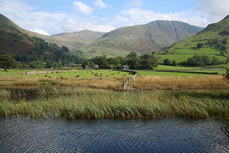
Hayeswater and Angle Tarn from Hartsop
Lake District Walk
Nat Park - Lake District - Lake District Far Eastern Fells
Wainwrights - Angletarn Pikes, Brock Crags, Gray Crag, High Street, The Knott, Thornthwaite Crag
County/Area - Cumbria
Author - Stephen Starkey
Length - 11.5 miles / 18.7 km Ascent - 3260 feet / 988 metres
Time - 9 hours 0 minutes Grade - mod/hard
Maps 

| Ordnance Survey Explorer OL5 | Sheet Map | 1:25k | BUY |
| Anquet OS Explorer OL5 | Digital Map | 1:25k | BUY |
| Ordnance Survey Landranger 90 | Sheet Map | 1:50k | BUY |
| Anquet OS Landranger 90 | Digital Map | 1:50k | BUY |
Walk Route Description
Click image to visit gallery of 5 images.
If you tell somebody you had a Lake District walk around Hayeswater, chances are they will think you mean Haweswater. Similarly, tell somebody you headed North across Kirkstone Pass, stopped at the first place you came to on the other side and set off for a walk, they would most likely think of Patterdale (or may be even Glenridding) and a route up Helvellyn with the hordes. One effect of such blinkered thinking is that there is good parking at Hartsop and the fells around the area are quiet.
The day I did this walk - a Sunday in September - the weather forecast was for a nice clear day (didn't turn out that way, hence the lack of too many photos, though it did clear nicely about 3:00pm when I finished the walk !). Throughout the entire 18+km, I met a grand total of 4 people and 1 dog - 2 people at Thornthwaite Beacon, the other 2 plus dog at Angle Tarn. By comparison, some friends who walked Helvellyn the same day counted 276 people across Striding Edge in the 1 hour they sat at the top of the climb from Striding Edge and this was on a day with very poor visibility. So, if you want peace and quiet!
The walk starts from the Cow Bridge car park (free) at Hartsop (Grid ref. NY402134) and heads back along the main road to the telephone box and the minor road to the "main centre" of Hartsop to pick up the bridleway that leads alongside Hayeswater Gill towards Hayeswater.
When the path splits at grid ref. NY415129, cross the bridge and take the path on the South (right hand) side of the beck and continue to climb gently. As the bulk of Gray Crag looms on the right, the path passes through a gate in the wall. Continue to follow the path for about another 50m, looking for a faint grassy path on the right. If unsure, the path is wider and more obvious part way up the hill and once spotted, the fainter path lower down the slopes can be detected. This path is not marked on any map I've seen but the CRoW Act overcomes any access problem.
This is the start of a very steep, very tough climb. The path heads initially towards the visible crags part way up the hill then bends round to the right and becomes more obvious as it follows the Northern shoulder of Gray Crag incessantly upwards. There is no respite for the lungs and calf muscles until gaining the summit ridge. The ridge has three 'tops', all marked by cairns. The first (and lowest) of the three is generally regarded as the "Wainwright" summit.
Once on the summit ridge, follow the now obvious path in a Southerly direction along the ridge. About 250m after passing the third (and highest) top on the ridge, the path passes through a gap in the wall. The path then climbs steadily to arrive at the huge beacon atop Thornthwaite Crags.
Follow the obvious path as it swings round to the SE / E / NE on to the High Street path, climbing gently along the route of a Roman Road, with Hayeswater Gill to the left and Blea Water to the right. From the cairn at the summit of High Street, either cut off to the West to rejoin the main path or alternatively follow the line of the wall / fence above Hause Crag to merge back with the main path to the Straits Of Riggindale and on to the summit of The Knott.
Follow the wall NW from the summit of The Knott then turn left on to a bridleway at the corner of the wall, rejoining the main path heading West then North West towards Angle Tarn. The earlier outward route along Gray Crag is now visible across the far side of Hayeswater. At the col (Grid ref. NY422138), the path crosses a wall junction by a combination of stile and gate then continues ahead. However, at this point I would recommend turning left away from the main path and following the visible track (again, not marked on any map) that follows the dry stone wall for a short distance before picking a way across the boggy flats to lead to the summit of Brock Crags, marked by a prominent cairn. From the summit cairn of Brock Crags, head North for about 30m to the secondary top that reveals fantastic views across Angle Tarn.
From Brock Crags, retrace your steps back to the main path by the gate then turn left to follow the main path to Angle Tarn. Once nearing the Northern end of the tarn, I feel it is worthwhile venturing away from the main path again and taking one of the visible paths (again, not marked on the maps) to climb to the lower of the two Angletarn Pike peaks that again offers superb views back South across the tarn.
Rejoin the main path and continue in a NNW direction once more, crossing wild moorland and, with ever improving views of Place Fell ahead, descending to a junction of many paths at Boredale Hause. At the Hause there are (on a clear day) terrific views across Patterdale to the Helvellyn range.
At Boredale Hause, keep bearing round to the left, crossing a small stream twice, to effectively double back and now descend, initially quite steeply, on the West side of Rake Crag. The descent soon eases to leave an easy walk out along a bridleway back to Hartsop.
Other walks nearby
| Walk 3309 | Hartsop, Hartsop Dodd, Stony Cove Pike & Kirkstone Pass | moderate | 8.5 miles |
| Walk 1228 | Thornthwaite Beacon & High Street | moderate | 6.5 miles |
| Walk 1959 | Gray Crag and Pasture Beck from Hartsop | moderate | 5.5 miles |
| Walk 2585 | Hartsop Dodd, Stony Cove Pike, High St. & The Knott | mod/hard | 10.0 miles |
| Walk 1230 | Birks & Arnison Crag | moderate | 5.5 miles |
| Walk 1520 | Helvellyn & Fairfield Horseshoe from Patterdale | very hard | 13.0 miles |
| Walk 2047 | Place Fell | moderate | 7.5 miles |
| Walk 2425 | Boredale Circular from Patterdale | mod/hard | 11.5 miles |
| Walk 3670 | Angle Tarn and Hayeswater | moderate | 8.3 miles |
| Walk 1156 | Helvellyn via Striding Edge | hard | 9.5 miles |
Recommended Books & eBooks
The Cumbria Way
 A guidebook to the 73 mile Cumbria Way, an easy long-distance walk though the heart of the Lake District National Park, from Ulverston in the south to Carlisle in the north, with good transport links to either end. The route is largely low-level but this guide offers alternative mountain days to climb some of the famous fells en route.
More information
Walking the Lake District Fells - Buttermere
 Part of the Walking the Lake District Fells series, this guidebook covers a wide range of routes to 32 Lakeland summits that can be climbed from the Buttermere, Lorton and Newlands valleys, with highlights including Haystacks, High Stile, Grasmoor and the fells of the Coledale Round. Suggestions for longer ridge routes are also included.
More information
Messaging & Social Media
Message Walking Britain and follow the latest news.

Mountain Weather
Stay safe on the mountains with detailed weather forecasts - for iOS devices or for Android devices.