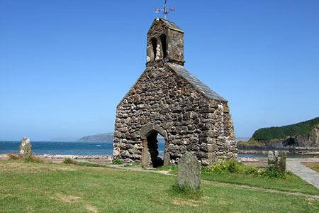
Dinas Island from Cwm-yr-Eglwys
Pembrokeshire Coast Walk
Nat Park - Pembrokeshire Coast
County/Area - Pembrokeshire
Author - Lou Johnson
Length - 3.0 miles / 4.9 km Ascent - 500 feet / 152 metres
Time - 2 hours 0 minutes Grade - easy
Maps 

| Ordnance Survey Explorer OL35 | Sheet Map | 1:25k | BUY |
| Anquet OS Explorer OL35 | Digital Map | 1:25k | BUY |
Walk Route Description
Click image to see photo description.
This circular walk around Dinas Island in Pembrokeshire offers a pleasant ramble following the Pembrokeshire Coast Path. Despite being described as an island, it is a peninsula being connected to the mainland between Fishguard and Newport. The highest point rises to 466 feet (142 metres) above sea level and you can enjoy extensive views to Strumble Head and across Newport Bay and Fishguard Bay. It is also worth spending time exploring the remains of Church of St. Brynach which suffered extensive damage during storms.
The walk starts from the pay and display parking area at Cwm-yr-Eglwys (grid ref. SN014400), which can be reached down a narrow lane from the A487 east of Fishguard. After parking follow the footpath from the rear of the parking and head west with Dinas Island rising on your right. Continue for just under a kilometre to reach Pwllgwaelod Beach (grid ref. SN005399).
Turn right following the Pembrokeshire Coast Path up a concrete lane soon enjoying views across Fishguard Bay. Where the lane bends right, go through the gate on the left. Ignore smaller paths on either side and follow the main path which is stepped in places. The path swings to the right and then veers left keeping close to the top of the cliffs on your left. The path soon reaches more open ground on this windswept headland. The views to Fishguard Bay improve as height is gained.
Reaching the OS trig point, you can enjoy a wide panorama which now includes Newport Bay. After enjoying the view, continue following the path (keeping the sea on your left). The descending path is easy to follow with a view along the cliffs with a backdrop of hills. Nearing the end of the walk, the path descends some steps, passes close to the sea before crossing a small footbridge. Once across the bridge, turn left and continue back to the start.
Other walks nearby
| Walk 2291 | Mynydd Carningli from Newport | easy/mod | 4.5 miles |
| Walk 3466 | The Preseli Ridge along the Golden Road | moderate | 6.4 miles |
| Walk 3465 | Foel Eryr Circular, Preseli Hills | moderate | 6.0 miles |
| Walk 3494 | Pwllygranant & Cebwr Bay from Moylgrove | mod/hard | 8.5 miles |
| Walk 3479 | Strumble Head & Garn Fawr Hillfort | moderate | 6.8 miles |
| Walk 3482 | Garn Fawr & Garn Fechan Hillforts | easy | 1.5 miles |
| Walk 3480 | Strumble Head from Garn Fawr | easy/mod | 5.0 miles |
| Walk 3481 | Carregwastad Point & Strumble Head Circular | moderate | 7.7 miles |
| Walk 3469 | Foel Cwmcerwyn from Rosebush, Preseli Hills | moderate | 5.0 miles |
| Walk 3490 | Cemaes Head & Clawddcam from Poppit Sands | moderate | 8.3 miles |
Recommended Books & eBooks
The Wales Coast Path
 A single guidebook to walking the whole Wales Coast Path - 1400km (870 miles) the length of Wales from Chester to Chepstow, including Anglesey, described in 57 stages. The route passes through the Snowdonia and Pembrokeshire National Parks and many AONBs and can be linked with the Offa's Dyke Path for a complete circuit of Wales.
More information
Messaging & Social Media
Message Walking Britain and follow the latest news.

Mountain Weather
Stay safe on the mountains with detailed weather forecasts - for iOS devices or for Android devices.