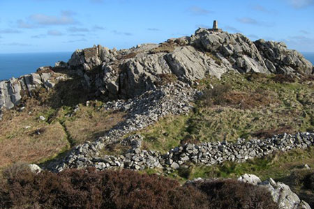
Garn Fawr & Garn Fechan Hillforts
Pembrokeshire Coast Walk
Nat Park - Pembrokeshire Coast
County/Area - Pembrokeshire
Author - Lou Johnson
Length - 1.5 miles / 2.4 km Ascent - 300 feet / 91 metres
Time - 1 hours 0 minutes Grade - easy
Maps 

| Ordnance Survey Explorer OL35 | Sheet Map | 1:25k | BUY |
| Anquet OS Explorer OL35 | Digital Map | 1:25k | BUY |
Walk Route Description
Click image to see photo description.
This short Pembrokeshire walk explores the interesting volcanic landscape to the east of Garn Fawr hillfort. The rough craggy moorland, near Strumble Head, and includes the iron age forts of Garn Fawr, Garn Fechan and Ysgubor Fawr. Although only a short walk you may want to linger on the summit of Garn Fawr in the evening to enjoy the glorious sunsets that can be seen from here.
The walk starts from a small car park below the eastern flank of Garn Fawr (grid ref. SM899388). To start the walk, exit the car park and cross the lane to join the footpath opposite (with the wall on your left). After a few minutes walking you reach open country with the rocky outcrop of Garn Fechan ahead. Follow the path which climbs to the left-hand side of this outcrop. Just after reaching a smaller outcrop on the right, the path divides. Take the left-hand fork and follow the path which soon runs parallel to a wall on your left. Go left through the gap in the wall to reach a grassy track/path.
Turn left to and continue to a lane. Turn left and continue to the access track for Tan-y-mynydd. Turn right down the track. After 100 metres, turn left onto a clear track. The track soon turns left and then right before continuing across the northern flank of Garn Fawr to reach a group of buildings. Continue ahead with the buildings on your right. Look out for a rising path on your left heading up to the right of a large crag. Once at the top you can enjoy the extensive view both towards the coast and inland. At 213 metres above sea level it is the highest land in the area. The descending path follows a wall (on your left) down to the carpark below.
Other walks nearby
| Walk 3481 | Carregwastad Point & Strumble Head Circular | moderate | 7.7 miles |
| Walk 1434 | Abercastle & Trefin Circular | moderate | 7.5 miles |
| Walk 3477 | Porthgain, Abereiddi Bay & Blue Lagoon | easy | 3.7 miles |
| Walk 3474 | Dinas Island from Cwm-yr-Eglwys | easy | 3.0 miles |
| Walk 3476 | Porthgain & Blue Lagoon from Abereiddy | easy/mod | 6.5 miles |
| Walk 2291 | Mynydd Carningli from Newport | easy/mod | 4.5 miles |
| Walk 2056 | Pointz Castle from Solva | easy/mod | 5.5 miles |
| Walk 3466 | The Preseli Ridge along the Golden Road | moderate | 6.4 miles |
| Walk 3465 | Foel Eryr Circular, Preseli Hills | moderate | 6.0 miles |
| Walk 1997 | St. David's & Coast Path Circular | moderate | 9.7 miles |
Recommended Books & eBooks
The Wales Coast Path
 A single guidebook to walking the whole Wales Coast Path - 1400km (870 miles) the length of Wales from Chester to Chepstow, including Anglesey, described in 57 stages. The route passes through the Snowdonia and Pembrokeshire National Parks and many AONBs and can be linked with the Offa's Dyke Path for a complete circuit of Wales.
More information
Messaging & Social Media
Message Walking Britain and follow the latest news.

Mountain Weather
Stay safe on the mountains with detailed weather forecasts - for iOS devices or for Android devices.