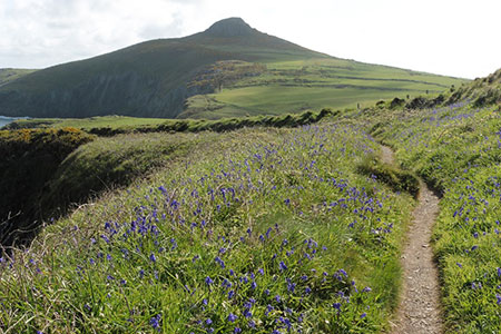
Penberry & St Davids Head from Whitesands Bay
Pembrokeshire Coast Walk
Nat Park - Pembrokeshire Coast
County/Area - Pembrokeshire
Author - Lou Johnson
Length - 9.0 miles / 14.6 km Ascent - 1500 feet / 455 metres
Time - 6 hours 0 minutes Grade - moderate
Maps 

| Ordnance Survey Explorer OL35 | Sheet Map | 1:25k | BUY |
| Anquet OS Explorer OL35 | Digital Map | 1:25k | BUY |
Walk Route Description
Click image to see photo description.
The Pembrokeshire walk explores St Davids Head and the rugged coast lying to the east where there are several hills offering great views along the coast and surrounding countryside. This walk includes an ascent of Penberry with the option of also climbing Carnedd-lleithr. The route needs careful navigation in places, so an OS map is recommended. There is an option to shorten the route at two points along the way.
The start is the car park at Whitesands Bay (Grid ref. SM734272), which can be reached by following the B4583 from St Davids. After parking walk back along the road towards St Davids. Take the first lane left after the caravan and camping site on your left. Follow this lane uphill. Fork right at the first junction and where the lane bends left turn right off the lane and follow a path through an area of rough ground to reach an access track to Llaethdy after 300 metres. Turn left up the track Just before the Youth Hostel turn right onto a signed footpath.
Continue along the right edge of two fields to pass Trefelly on your right. Cross a track and continue in the same direction across two fields (field boundary on your right) to cross another grassy track. Walk to the left of the remains of a ruined building and continue to reach Treleddyd-fawr. There is a maze of tracks and paths here, so a map is particularly useful. You need to locate the path heading north-east to Llanferran. The path runs along the right-hand side of several fields, passes through the farmyard, and joins a track. Continue ahead and follow the track round to the right (with a large pond on your right). Reaching a smaller pond, also on your right, turn left onto an enclosed path (grid ref. SM763285). The path soon turns sharp right and leads to Treleidr (grid ref. SM766286).
Turn left onto a grassy track heading north with Penberry in view ahead. Continue to reach open country and follow the wall on your left until the end of the wall (grid ref. SM765292). The route now climbs Penberry. However, you can shorten the route by omitting this section by continuing with the next paragraph. Turn right at the wall end on follow the path north-east. Reaching a wall on your left, continue by the wall for a short way to turn right on a path that leads to the summit of Penberry. After enjoying the view return to the end of the wall (grid ref. SM765292).
Turn left onto the Pembrokeshire Coast Path. As you descend you have an excellent view ahead to St Davids Head and the rugged hills that are typical of this area. The undulating cliff op path provides superb walking After two kilometres and after passing through several gates you reach a marker post on the left (grid ref. SM749287). (You can shorten the walk by continuing along the coast path here - continue to next paragraph). Turn left and follow this path uphill. Maintain direction with Carnedd-lleithr rising on your right. Follow the path to reach a wall coming in from your left. Turn right here and following the rising path to the summit. Descend on the path heading north to reach a wall. Turn left along the wall and then right down an enclosed path between walls. At the end of the enclosed section, turn left following the wall to a corner where you turn half right back to the Coast Path.
Continue west along the coast path. It is worth occasionally looking back as you can see as far as Penberry. Continue to reach St Davids Head from where you have a good view to Whitesands Beach and across to Ramsey Island. It is possible to take a short cut across the headland, but my preference is to follow the Pembrokeshire Coast Path all the way around the headland before continuing south back to the start.
Other walks nearby
| Walk 1997 | St. David's & Coast Path Circular | moderate | 9.7 miles |
| Walk 1210 | Porth Clais & St Justinian's | easy/mod | 5.5 miles |
| Walk 3476 | Porthgain & Blue Lagoon from Abereiddy | easy/mod | 6.5 miles |
| Walk 2056 | Pointz Castle from Solva | easy/mod | 5.5 miles |
| Walk 3477 | Porthgain, Abereiddi Bay & Blue Lagoon | easy | 3.7 miles |
| Walk 1434 | Abercastle & Trefin Circular | moderate | 7.5 miles |
| Walk 2485 | Broad Haven & Druidston Circular | easy/mod | 4.9 miles |
| Walk 3473 | Marloes Peninsular Circular | easy/mod | 7.0 miles |
| Walk 3362 | Marloes Sands Circular | easy | 4.5 miles |
| Walk 3367 | Nab Head & Musselwick Sands from Marloes | easy/mod | 6.2 miles |
Recommended Books & eBooks
The Wales Coast Path
 A single guidebook to walking the whole Wales Coast Path - 1400km (870 miles) the length of Wales from Chester to Chepstow, including Anglesey, described in 57 stages. The route passes through the Snowdonia and Pembrokeshire National Parks and many AONBs and can be linked with the Offa's Dyke Path for a complete circuit of Wales.
More information
Messaging & Social Media
Message Walking Britain and follow the latest news.

Mountain Weather
Stay safe on the mountains with detailed weather forecasts - for iOS devices or for Android devices.