Walk 3496 - printer friendly version
St Anne's Head & Dale Peninsula Walk
Author - Lou Johnson
Length - 7.0 miles / 11.4 km
Ascent - 900 feet / 273 metres
Grade - easy/mod
Start - OS grid reference SM811059
Lat 51.7090180 + Long -5.1697939
Postcode SA62 3RA (approx. location only)
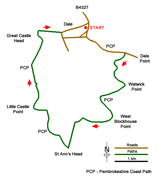
This is an excellent walk around the Dale peninsula in Pembrokeshire. The route, which follows the Pembrokeshire Coast Path for most of the way, offers views across the entrance to Milford Haven to the Angle peninsula, passes the lighthouse on St. Anne's Head, enjoys excellent coastal scenery throughout and visits the sandy beach at Westdale Bay.
The start is the car park beside the sea on the west side of the B4327 at Angle (grid ref. SM811059). Exit the car park and turn left along the seafront. Bear left where the road forks with the sea to your left. Pass the slipways and then the Griffin Inn on your right. Since leaving the car park you have been following the Pembrokeshire Coast Path (also the Wales Coast Path). Keep straight ahead following a narrow lane. You pass through woodland with glimpses of the sea to your left. As you leave the trees, you can enjoy uninterrupted views once more.
Leave the lane by turning right through a waymarked wooden gate (grid ref. SM821053). The grassy path cuts across Dale Point and soon follows the clifftops as it skirts Castlebeach Bay. The path descends into a side valley, crosses a wooden footbridge, climbs a few steps, and soon regains the clifftop. The undulating path is never too demanding, and you soon pass the prominent navigational tower on Watwick Point. The onward route skirts Watwick Bay where you should follow the waymarked coast path ignoring paths descending to the beach on your left. Across the estuary is the Angle peninsula.
Continue past more navigational aids on West Blockhouse Point and continue around Mill Bay to reach St Anne's Head where pass close to the lighthouse which lies behind a row of cottages on the left. Continue past the old lighthouse following a tarmac drive. Just after a stone gateway turn left through a wooden gate (with fingerpost) to continue along the coast path. The path follows the clifftop above Frenchman's Bay and then after reaching Little Castle Point passes above Welshman's Bay.
After passing Great Castle Head, the site of an Iron Age fort, the path drops to Westdale Bay. Reaching a gate with stone pillars and a fingerpost (grid ref. SM800059), turn right and follow the path through a shallow valley towards the village of Dale. Reaching a track, continue straight ahead to reach a tarmac road at a bend (grid ref. SM805058). Continue ahead with the stone wall on your left. Pass the church on your right and continue ahead to reach the seafront. Turn right and the car park used at the start is on your right.
Messaging & Social Media
Message Walking Britain and follow the latest news.

Mountain Weather
Stay safe on the mountains with detailed weather forecasts - for iOS devices or for Android devices.